
A risk of some heavy snowfall later next week and freezing temperatures dropping lower than -5C
Good evening everyone it's been another interesting day of weather model watching with all forecasts models showing the weather turning much colder next week with each day now temperatures dropping but particularly over the early days of next week and mid week next week. We are looking like we are going to enter a prolonged spell of colder weather possibly lasting beyond next weekend. See the latest forecast below for this weekend and next week.
SATURDAY
Saturday will see plenty of dry weather for much of the country however some outbreaks of rain or drizzle may effect north-western and western areas during the afternoon, evening and early night. Temperatures by day of between 5C to 7C. Temperatures by night -1C to 4C coldest in the northwest with the risk of some frost.
SUNDAY
Sunday be a mainly dry day for many areas but come Sunday winds will be coming from the east with that colder air starting move down across Ireland. There will be some showers across northeastern, and eastern areas on Sunday with some of these possibly turning wintry with rain, hail and sleet to low levels and snow over the mountains. Further west it looks drier but a isolated shower or 2 can be ruled there possibly wintry also. Temperatures by day of 4C to 7C.. Temperatures by night 0C to 4C.

MONDAY
Monday looks set to be a mostly dry day with some sunny spells but a few isolated showers blowing in of the Irish sea over the eastern half of the country will be possible. Temperatures by day will range between 4C to 6C
Overnight we are likely to start seen the first of the frosty nights with temperatures dipping below freezing especially in the northwest were it will be coldest
Temperatures by night 0C to -3C in the northwest and around 0C to 4C away from the northwest.
TUESDAY
Tuesday will be a mainly dry and cold day with sunny spells. Winds will turn to a more Northeasterly position. Temperatures will range between 3C to 5C.
Overnight will be cold everywhere with frosty and icy conditions will low of around 0C to -3C.
WEDNESDAY
Very cold air will flood down across Ireland later Tuesday night into Wednesday and it will turn very cold with the latest model runs showing day time temperatures only around 1C to 3C. During the evening and night parts of Ulster, North Connacht and parts of the east looks set to see wintry falls moving in from the coasts with some dustings of snow possible in places overnight. The latest models also are forecasting a severe frost and very cold evening and night with temperatures below freezing nationwide as soon as it gets dark. Temperatures look set to range between -1C to -6C coldest in Connacht, Ulster and Leinster.

THE REST OF THE WEEK
All forecast models now show the cold weather continuing into the weekend and possibly early next week. There is some uncertainty past this point what will happen especially with precipitation but some disruptive and hazardous conditions could well develop in the way of ice and snow.
Some places across Northern parts of Connacht and Ulster could wake up to a dusting of snow on Thursday morning due to overnight shower or sea streamers moving in of the sea.
Thursday and Friday most of the weather forecasting models forecast very cold days with temperatures staying below freezing in some places with day time highs between -2C to 2C possibly a little warmer along southern coastal areas around 3C to 4C. Further wintry showers of snow are likely in places with northern Western and Eastern areas at the highest risk with some accumulations possible. Some models show overnight temperatures at the end of next week into next weekend could fall as low as -5C to -8C in some places but that would depend on snow cover which can lead to colder overnight temperatures over snowfields.
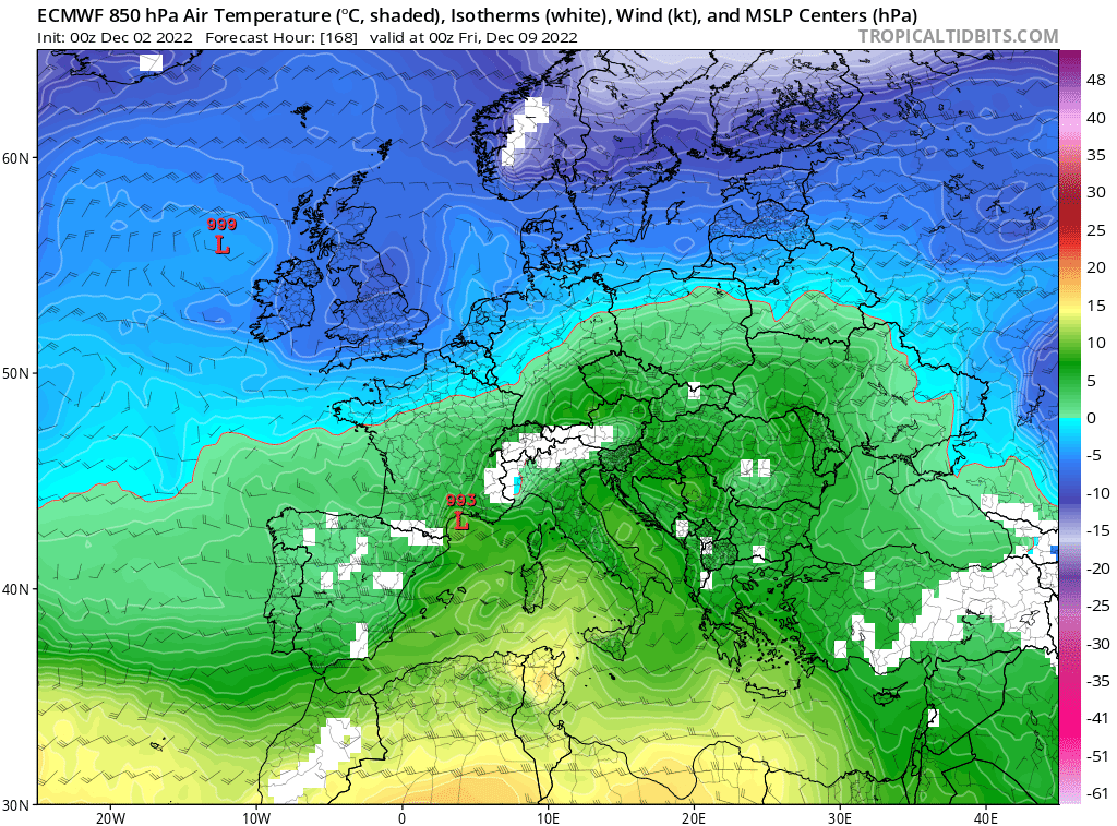
POSSIBLE OUTCOME FOR HEAVY SNOWFALL

ECMWF model run from this morning show low pressure to the south moving northwards later next week and hit the colder air resulting in heavy widespread snowfall
Another outcome at the end of next week into next weekend what could happen as seen in the above chart is we have a more widespread fall of snow like what the Ecmwf model was showing this morning. It takes a low pressure system which is located to the south of Ireland and moves it northwards up across Ireland and as that rain (precipitation) hits that very cold air across Ireland it falls as heavy snowfall giving accumulations.
This is not guaranteed but it is something the European and American forecast models have suggest could happen on and off the last few days so it one to watch.
It will be Sunday at the earliest into early next week before we have any real idea on the snowfall forecast for areas and what the likely outcomes will be. If we see the forecast model continue shown these charts over the next 36hr to 48hrs I'd expect an early weather Advisory to be issued by Met Éireann as early as Sunday due to the possible disruption.
Stay tuned over the weekend for further updates as detail become more clear. Have a nice weekend
Kenneth from the Donegal Weather Channel
LATEST NEWS


