
Monthly Long Range Forecast Update Ireland - 24th May 2021

Warmer and drier weather this weekend expected across Ireland
The Donegal Weather Channel Monthly Long range forecast issued every week looking up to a month ahead using data from the ECMWF and GFS models.
Please note that the longer range forecasts are more uncertain and should not be used to plan outside activities from over a week out.
Extended Range Output
The output is rather different from the shorter period output of HRES and ENS products. It provides a more general overview of the forecast up to Day 46, focusing mainly on the week-to-week changes in the weather rather than attempting to give unsupportable detail on individual days. Output is mostly in the form of anomalies relative to ER-M-climate and is mainly shown as 7-day means for calendar weeks Monday-Sunday. Specialised products for the extended range also include information on potential tropical cyclone activity and the MJO during the coming month.
SPONSOR THE LONG RANGE FORECAST
If you have a business and would like to sponsor our weekly month long range forecast for a period of 1 week or 1 month please do contact Donegal Weather Channel at info@donegalweatherchannel.ie or message our Facebook page . Donegal Weather Channels service relies on sponsorship/advertising. Without sponsorship/advertising Donegal Weather Channel would not be able to give so many hours and a daily service.

The forecast will be issued by myself Kenneth and i will try to keep it simple making it easy for everyone to understand. If there is a term I use in the forecast which you may not know what it means I will explain what I am talking about .
Before I start with the long range forecast I will just explain what we will be looking at and how the forecast will work.
The forecast will be broken up into 4 section Example below :
Week 1 - Monday 24th May 2021 -Monday 31st May 2021
Week 2 - Monday 31st May 2021 -Monday 7th June 2021
Week 3 - Monday 7th June 2021 -Monday 14th June 2021
Week 4 - Monday 14th June 2021 -Monday 21st June 2021
Things we will look at in the forecast:
Mean sea level pressure: Weekly mean anomalies
2m temperature: Weekly mean anomalies
Wind
Precipitation: Weekly mean anomalies (eg. rainfall and snowfall for a example.
Dust forecast ( Only in Week 1)
UV forecast outlook
Potential Pollen Levels

Forecaster - Kenneth Mc Donagh
Week 1 - Monday 24th May 2021 -Monday 31st May 2021
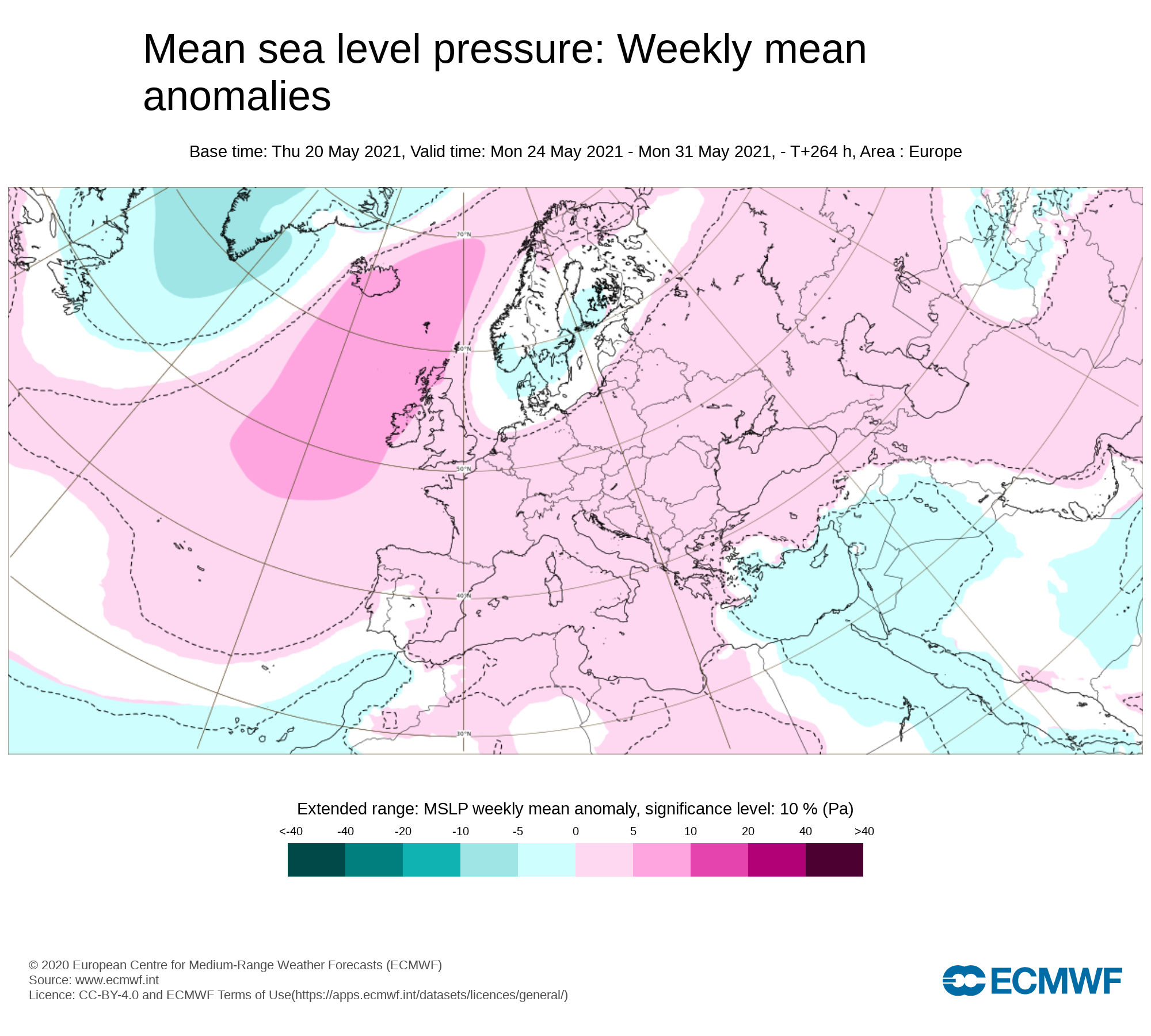
Mean sea level pressure: Weekly mean anomalies
This week will start of with lower pressure than average to the northeast of Ireland but higher pressure will build later this week and over this weekend which will bring less rainfall and more settled conditions
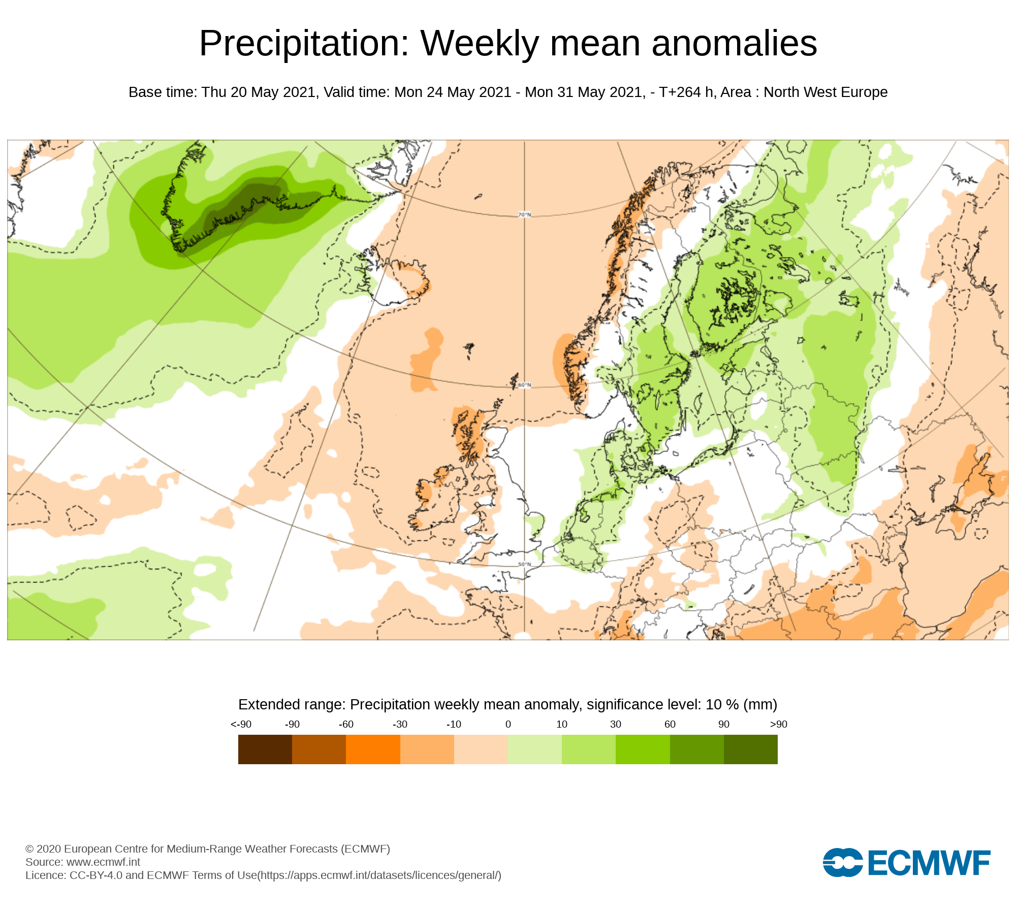
Precipitation ( Rainfall ): Weekly mean anomalies
Rainfall amounts over week 1 this week will be below average again away from the southern half of Ireland but near normal in some areas. The highest rainfall amounts this week will be across the southwest, south and southeast which seen the highest rainfall amounts last week with 69mm of rain recorded in the southwest of Ireland. The driest parts of Ireland this week will be Connacht, Ulster and north Leinster. Malin head Donegal last week was the driest part of Ireland with only 14mm of rain there.
Monday will see some showers with the southern half of Ireland most at risk with the northern half of Ireland staying mostly dry but rather overcast
Tuesday morning will see rain across Munster and some southern coastal areas of Leinster but it will be dry elsewhere with some clear spells and perhaps of few scattered showers. Tuesday afternoon and evening will be a largely dry day for Much of Connacht, Ulster and Leinster with nice sunny spells but with the sunshine and solar heating it may trigger a few showers of over the later stages of the afternoon mainly across parts of Leinster. Munster will see a rather overcast day when early morning rain clears with some rain and drizzle continuing over parts of Cork and Kerry during the afternoon.
Wednesday will be rather much the same with mainly dry weather across Ulster, Connacht and north Leinster with overcast conditions across Munster and south Leinster where there will be a risk of some rain and drizzle. Overnight looks set to be dry across Connacht, Ulster and Leinster but cloud and rain spreading into Munster and south Leinster later in the night moving northwards
Thursday looks set to be the wettest day this week with a band of rain moving northwards across Ireland over the morning and clearing to the northeast on Thursday evening with bright and sunny spell spreading from the southwest and west as high pressure builds from the southwest.
Friday looks set to be a mainly dry across Ireland with higher pressure in places with bright and sunny spells for many but perhaps a little cloud around also.
Saturday & Sunday
This weekend is looking rather nice across Ireland as higher pressure sits across Ireland bringing warmer and drier weather across the country. With sunny and warmer conditions this may trigger a few showers in the afternoon and evening in a few places but overall good sunny spell for much of Ireland.
Rainfall amounts between Monday 24th May to Sunday 31st May 2021
Ulster - 10mm to 20mm ( Highest amounts in west Ulster over the mountains)
Connacht - 5mm to 20mm ( Highest amounts in west Connacht especially over high ground areas)
Munster - 20 mm to 30mm (Highest amounts in south & west Munster especially across higher ground areas)
Leinster - 10 mm to 30mm (Highest amounts in south Leinster over the mountains)
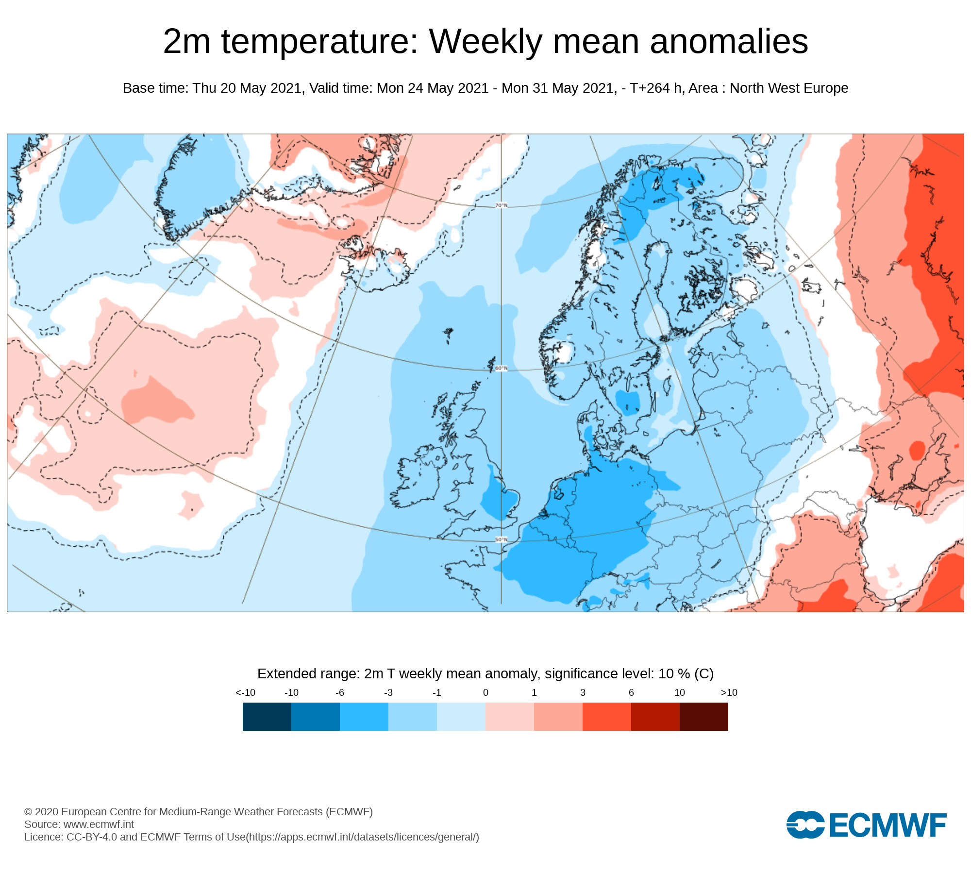
Temperature: Weekly mean anomalies
Temperatures over this week (week 1) will be below normal across Ireland between 1C to 2C below. There will be no risk of frost this week . Overall day time temperatures will range between 10C to 14C/16C up until Thursday. Turning warmer on Friday and this weekend with temperatures into the high teen and low 20s in places with the northwest looking the warmest this weekend
Wind forecast
No Strong winds are expected this week.
UV forecast
Even with a cooler week than average for this time of year expected UV levels will be Moderate in any sunshine early this weekend but high over this weekend with the risk of sun burn possible.
Pollen Forecast
Pollen levels will be moderate to high over the week with pollen levels lowest during cloudy and wet weather and highest during any sunny & dry periods. The main type of pollen will be tree this week.
Dust forecast
Dust levels will be low across Ireland during week 1.

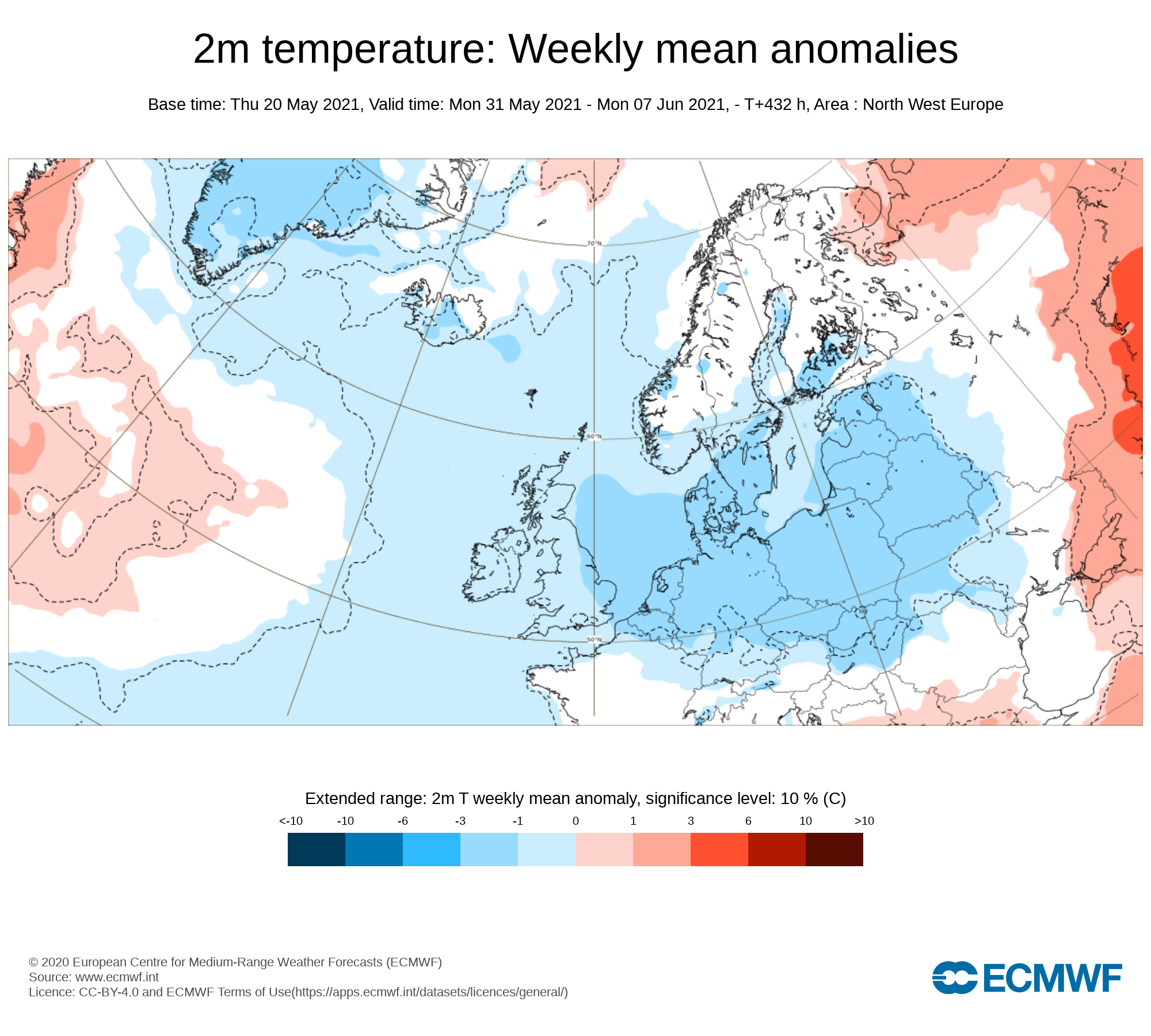
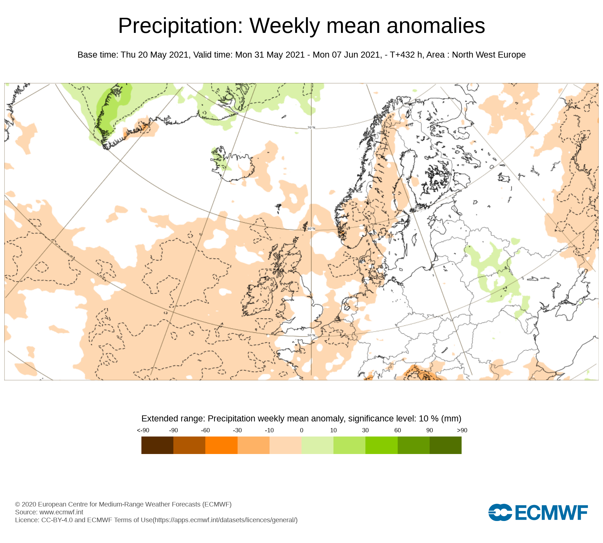
Week 2 - Monday 31st May 2021 -Monday 7th June 2021
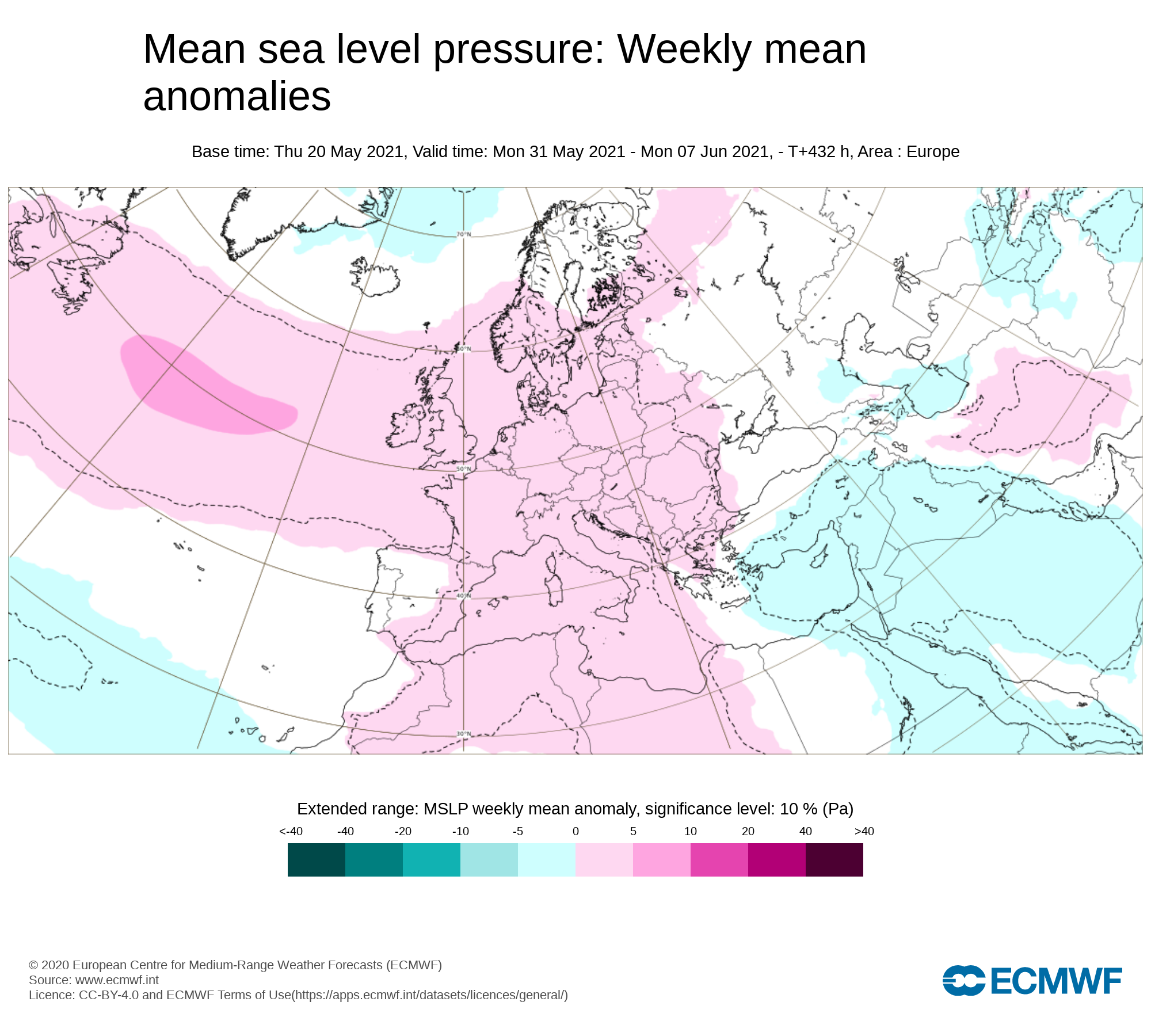
Mean sea level pressure: Weekly mean anomalies
The latest outlook heading into week 2 is for is for above average pressure to sit across Ireland meaning that there will be a good chance of seen some good sunny spells at times
Precipitation ( Rainfall): Weekly mean anomalies
The latest trend for this week shows rainfall amounts below average for many places but not fully dry with the chance of some showers over the week some which could come in the form of thunderstorms especially in any warmer weather.
2m temperature: Weekly mean anomalies - Wind
Temperatures for this week will be just below normal for June but still feeling warmer than past few weeks with temperatures in the mid/high teens to low 20s in places possibly.
Wind Forecast
At present there looks like there will be no risk of strong winds over week 2
UV forecast
UV levels will be Moderate to high in any sunshine with the risk of sun burn.
Pollen Forecast
Pollen levels will be high to very high over the week with pollen levels lowest during cloudy and wet weather and highest during any sunny dry periods.. Grass pollen also is likely then start to rise this week especially in any warmer weather.
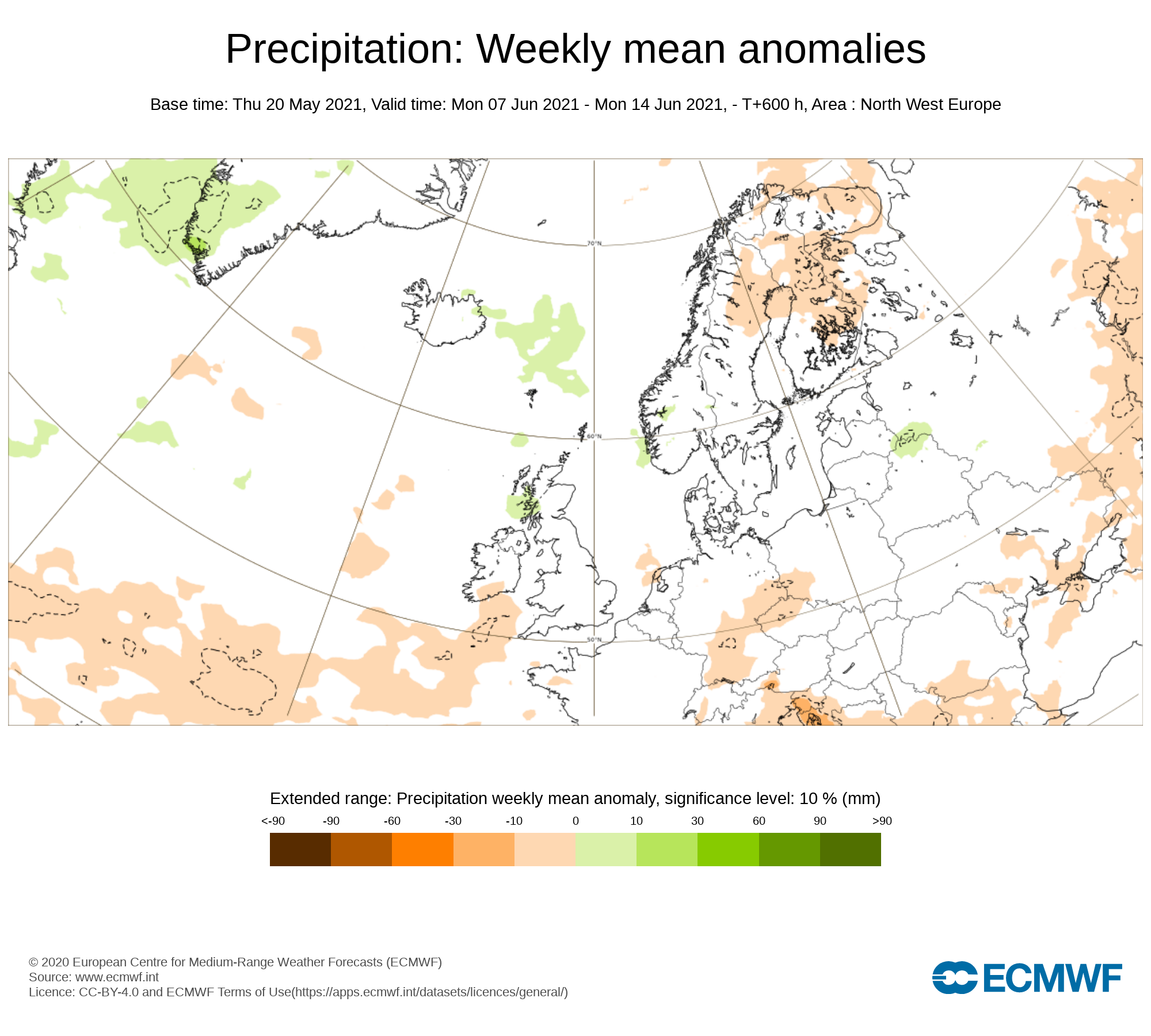
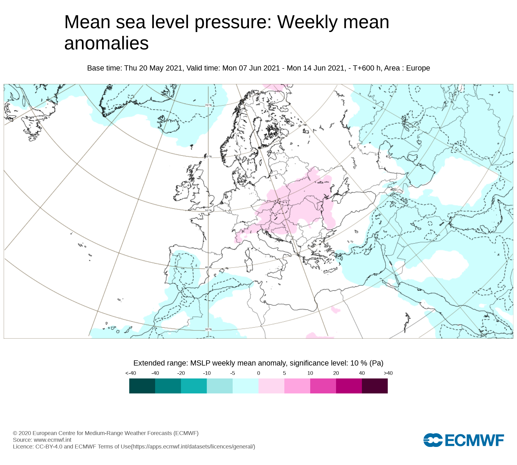
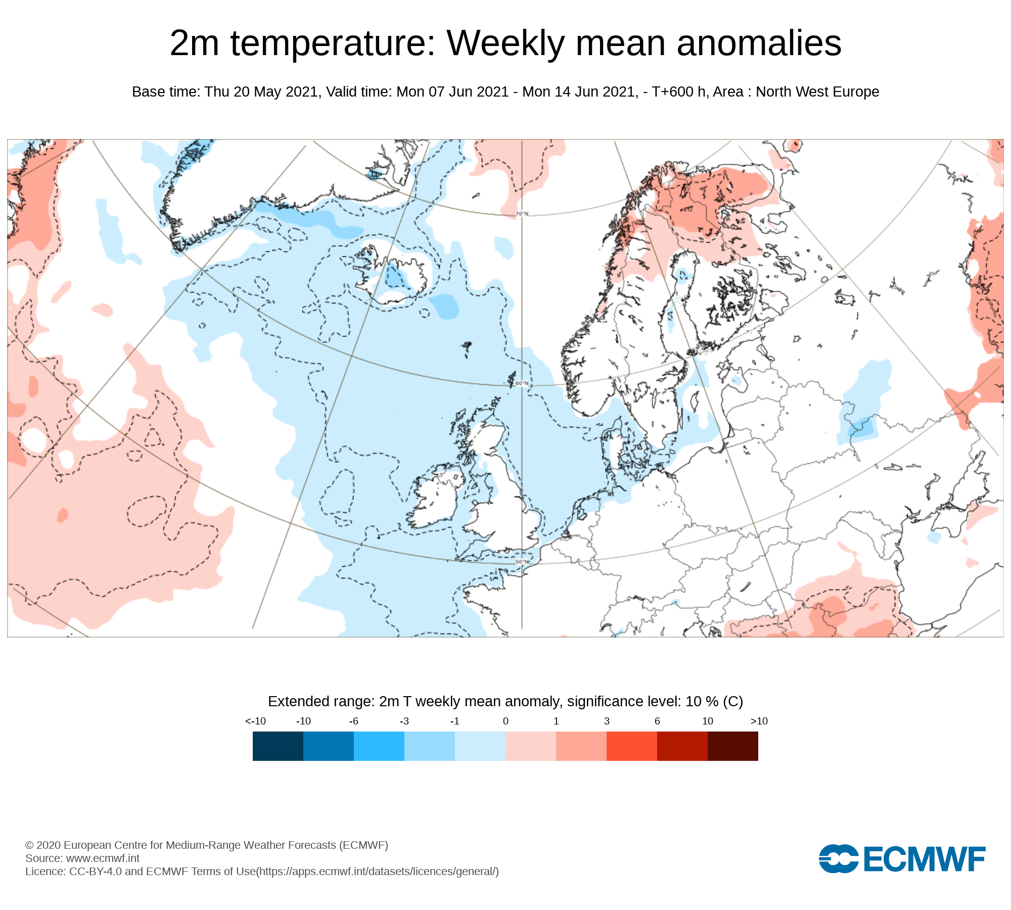
Week 3 - Monday 7th June 2021 -Monday 14th June 2021


Mean sea level pressure: Weekly mean anomalies
Confidence in this week is rather low and more uncertain. The latest signals are for high pressure to break down with more of a influence from the Atlantic across Ireland bringing the higher chance of much wetter weather.
Precipitation ( Rainfall): Weekly mean anomalies
Rainfall amounts look set to be average or just above on week 3 across Ireland
2m temperature: Weekly mean anomalies
Temperatures would be near normal in the high teens to low 20s in places during week 4.
Wind forecast
There are no signs of any strong winds this week with settled weather and high pressure building bringing rather settled weather.
UV forecast
UV levels will be Moderate to High in any sunshine with the risk of sun burn.
Pollen forecast
Pollen levels will be moderate high over the week with pollen levels lowest during cloudy and wet weather and highest during any sunny dry periods. Grass pollen also is likely to be the main pollen type this week
Week 4 - Monday 14th June 2021 -Monday 21st June 2021
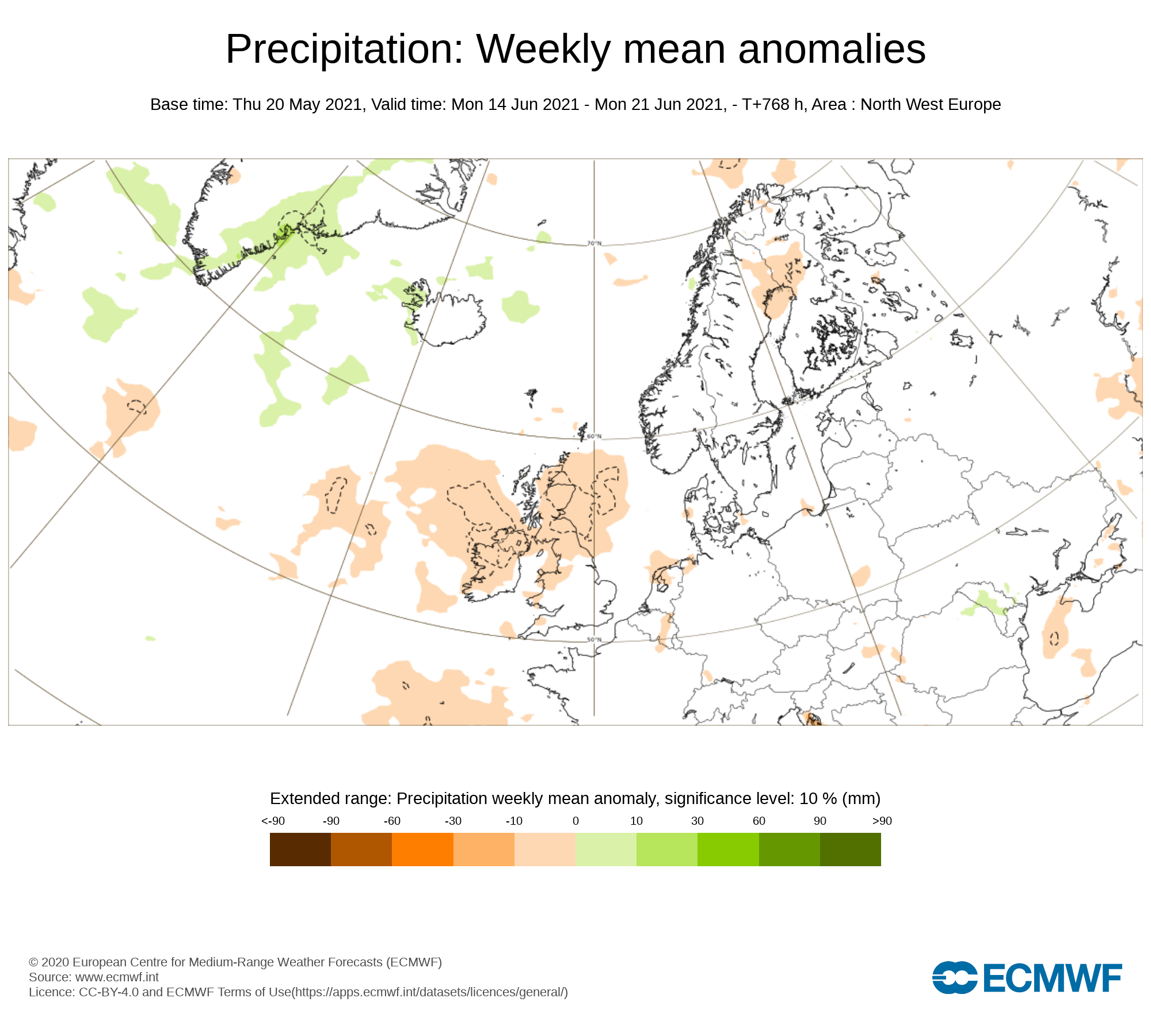
Mean sea level pressure: Weekly mean anomalies
There are signals that higher pressure will try to build across Ireland again this week our just sit to the north of Ireland but again confidence is rather low at this range.
Precipitation ( Rainfall): Weekly mean anomalies
Rainfall amounts are forecast to below average across Ireland this week with a lot of dry weather
2m temperature: Weekly mean anomalies
Temperatures would be near normal in the high teens to low 20s in places during week 4 possibly into the mid 20s.
Wind forecast
There are no signs of any strong winds this week with settled weather and high pressure building bringing rather settled weather.
UV forecast
UV levels will be Moderate, High in any sunshine with the risk of sun burn.
Pollen forecast
Pollen levels will be high to very high over the week with pollen levels lowest during cloudy and wet weather and highest during any sunny dry periods. Grass pollen also is likely to be the main pollen type this week


