
UPDATE - Risk of 2 powerful storms this weekend and next week

Just a quick update regarding the very unsettled period we look likely to enter.
SATURDAY NIGHT AND SUNDAY
First of all the first very windy period to watch is Saturday night and Sunday when a area of low pressure moves passed the northwest of Ireland bring potentially severe and damaging gusts but details on this is yet to uncertain. Possibly the risk of coastal flooding also.
Continues below


MONDAY
Monday then a very cold Polar maritime airmass like we seen at the start of last week will bring the risk of similar conditions with falls of snow for places. It will also remain windy but gusts not severe.
TUESDAY INTO WEDNESDAY
By midweek next the jet stream looks set to become very strong with a area of low pressure showing on models for some time now and shows the threat of a even stronger period of winds than Sundays low. This could give widespread severe and damaging gusts with some areas seen extreme gusts. Extensive coastal flooding would also occur due to high spring tides.
A area of low pressure will pass of to the north of Ireland overnight with a strong winfield to the southern flank of the low. Overnight. Northwest winds will increase across the northwest and North of Ireland with mean speeds of 50 to 60 km/h and gusts of 90 to 100 km/h. Strongest near coasts.
Later next week looks set to stay rather unsettled with further wet and windy weather and the risk of wintry showers possibly at times. From Saturday night into the middle of next week there is a potential for very disruptive weather.
The next name storm will be storm Ciara, followed by Dennis.

CHART 1
this shows the risk of strong winds on Sunday. Taken from the ECMWF model.

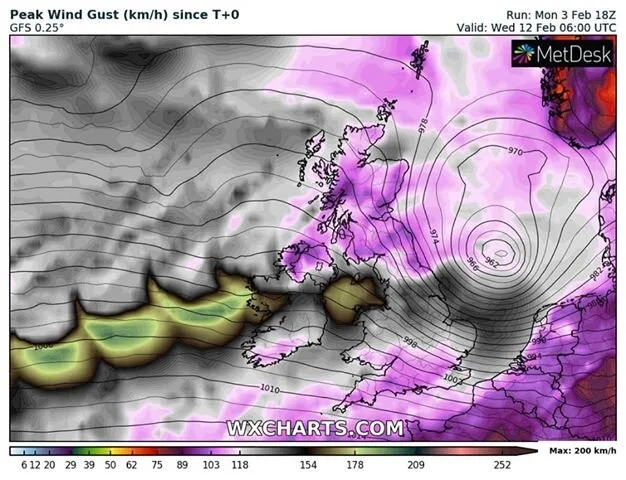
CHART 2
Shows a very powerful wind storm on Tuesday into Wednesday. Taken from the GFS Model.

CHART 3
Shows a very powerful wind storm on Tuesday into Wednesday. Taken from the ECMWF Model
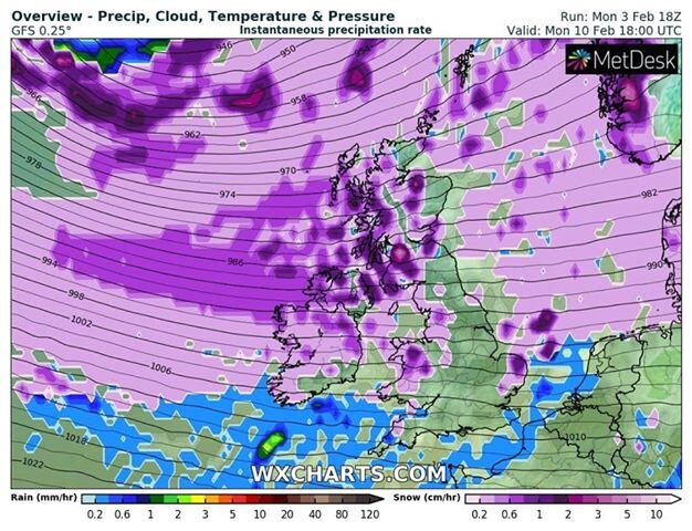
CHART 4
Shows the risk of snowfall on Monday as colder polar maritime air hits Ireland. Both the ECMWF and GFS show this outcome.
Note that these charts are subject to change over the next few days and if any changes occur I will keep you updated.
Kenneth from the Donegal Weather Channel


Click on the tabs below to view the new forecasts available under the forecast section.
2019 CALENDAR NOW ON SALE


2019 Calendar now on sale
You can now purchase the Donegal Weather Channel Calendar 2019. You can purchase the Calendar from the online store
All calendars will be posted out in the middle of November with only a limited amount available. Calendars can be purchased anywhere across the world.


The stunning Leitir Mhic An Bhaird (Lettermacaward) Donegal during May 2018

Vivid Rainbow from up on Breezy mountain South Donegal

I was in Albufeira Portugal I was waiting for the full moon to come up and it did not let me down.
The orange and red tints that the Moon sometimes take on rising and setting are caused by the particles in the Earth's atmosphere. When light (or more specifically, packets of light called photons) from an astronomical object passes through the Earth's atmosphere, it scatters off of particles in the latter.

What a unbelievable night and morning out storm chasing, These number of thunderstorms had to be the best in years as most of the lightning was CG bolts. I even manage to captures Two to three CG bolts in one shot.

One of the most beautiful views of Slieve league From sea and got some nice photos.
Photos from this angle I have not seen yet and it was wonderful to finally capture that moment.