
Risk of a named storm on Sunday with wintry falls of snow in places


Tuesday, Wednesday and Thursday will be mainly dry everywhere across Ireland with some nice sunshine at times for most areas. The reason for settled weather over the coming days is due to High pressure which is sitting close to Ireland just of to the south of the country.

High pressure sittning of the south of Ireland today Tuesday 04/02/2020
Tuesday night will turn very cold with temperature dropping between -2C to 1C with a widespread sharp to severe frost forming across Ireland with the risk of icy roads on any wet surfaces.
Wednesday night will again be cold but not as cold as Tuesday night with clear spells for many areas but there will tend to be cloudier condations across the south and southwest. Temperatures overnight will range between 5C to 6C across the southern half of Ireland and 1C to 3C across the north, east and west with the small risk of a frost for some areas.
Continues below


FRIDAY 7TH AND SATURDAY 8TH FEBRUARY
Later Friday afternoon and evening a band of rain will move in of the Atlantic spreading eastwards overnight before clearing of to east over the Irish sea just after midnight.

A band of rain spreading across Ireland on Friday evening and night clearing Saturday morning
On Saturday morning it will start of with bright and sunny spells for many areas with some showers possible along the southwest, west and northwest. After midday a spell of rain will again move in from the Atlantic crossing Ireland over the afternoon and evening clearing to the east overnight with drier weather following behind from the west.

A band of rain spreading across Ireland later Saturday afternoon and evening clearing to the east on Saturday night
On Saturday afternoon and evening there will also be the risk of strong winds in places at present these wind look strongest across Connacht and Ulster with some coastal areas in these regions seen gust between 90km/hr to 120km/hr particularly across exposed coastal areas. Further inland across Connacht and Ulster winds will gust between 70km.hr to 110km/hr. Elsewhere across Leinster and Munster on Saturday winds will tend to gust between 50km/hr to 100km/hr but possibly as high as 110km/hr across some western coastal counties of Munster.
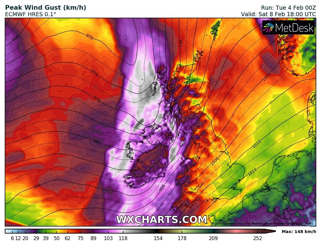
windy weather with the risk of some strong gusts on Saturday afternoon and evening especially across Connacht and Ulster.
The rain and wind looks set to clear through on Saturday night with a brief respite in conditions.
Continues below
SUNDAY 9TH FEBRUARY
On Sunday morning it then looks set to turn very windy with the risk of potential severe and damaging winds with the risk of coastal flooding.
Sunday morning a area of low pressure looks set move of the northwest and north coastal of Ireland with the area of low pressure deepening as it does so. At present the strongest winds look set to be across west Munster Connacht and Ulster but rather strong winds across Leinster also.
Currently the latest ECMWF model shows the risk of winds gusting between 110km/hr to 130km/hr across much of west and north Ulster - ( Donegal, Derry, Antrim, Fermanagh & Tyrone) Connacht - (Sligo, Leitrim, Roscommon, Mayo & Galway) west Munster - (Limerick, Clare, Kerry & possibly Cork).
Elsewhere winds look set to gust between 100km/hr to 120km/hr across the rest of Ireland.
Across Donegal, Derry, Antrim, Sligo, Leitrim, Mayo and Galway with show the potential to be in the high level Orange criteria to low level red cretira with gust of up to 140km/hr but this is subject to change over the next few days.

Very strong wind across Ireland on Sunday with a deep low moving of the northwest and north coastal of Ireland
Continues below
Coastal Flooding
On Sunday if we still are looking at similar forecast charts from what the have been showing the last few days there will be a significant risk of coastal flooding also across the southwest, west and particularly across the northwest and north of Ireland.
A large swell, big waves and strong winds could lead to coastal flooding and a storm surge especially around high tide

Large swell and wave possibly giving high sea combined with strong winds leading to coastal flooding on Sunday

The latest ECMWF also shows a band of heavy rain moving in on Sunday am and clearing over the afternoon and possibly even falling as sleet and snow for some areas on Sunday but this is yet to far out to say for sure and will only be able to forecast around 24 hours in advance
Continues below
MONDAY 10TH FEBRUARY
A colder air mass then moves down on Sunday night into Monday all the way from Canada this air mass in known as a polar maritime air mass and models are constantly showing the risk of wintry falls of sleet and snow on Monday for many areas especially across Ulster and Connacht.

Wintry falls of sleet and snow on Monday with the risk of thunderstorms also

Wintry falls of sleet and snow on Monday with the risk of thunderstorms also

A very cold air mass originating from Canada on Monday with upper air temperatures of around -6C that could lead to the risk of wintry falls of sleet and snow throughout Monday. These upper air temperatures are 1500 meters above sea level.
Continues below
JET STREAM
The reason for this very unsettled period of weather is due to a very strong and powerful jet stream which is set to power up over the weekend bring low in of the atlantic acting like a conveyor belt. For more on what the JET STREAM is click here

Very powerful jet stream over the weekend and early next week
Continues below
TUESDAY 11TH AND WEDNESDAY 12TH FEBRUARY
The outlook for next Monday night into Tuesday morning is for further wintry falls of sleet and snow with that very cold air still across Ireland. Heading into Tuesday night and Wednesday models show a potential for another storm over the past few days but this evening the ECMWF and GFS has backed away from this.
For this time next week the weather is impossible to tell but the outlook does look set to be rather unsettled with wet and windy weather at times.
Kenneth from the Donegal Weather Channel


Click on the tabs below to view the new forecasts available under the forecast section.
2019 CALENDAR NOW ON SALE


2019 Calendar now on sale
You can now purchase the Donegal Weather Channel Calendar 2019. You can purchase the Calendar from the online store
All calendars will be posted out in the middle of November with only a limited amount available. Calendars can be purchased anywhere across the world.


The stunning Leitir Mhic An Bhaird (Lettermacaward) Donegal during May 2018

Vivid Rainbow from up on Breezy mountain South Donegal

I was in Albufeira Portugal I was waiting for the full moon to come up and it did not let me down.
The orange and red tints that the Moon sometimes take on rising and setting are caused by the particles in the Earth's atmosphere. When light (or more specifically, packets of light called photons) from an astronomical object passes through the Earth's atmosphere, it scatters off of particles in the latter.

What a unbelievable night and morning out storm chasing, These number of thunderstorms had to be the best in years as most of the lightning was CG bolts. I even manage to captures Two to three CG bolts in one shot.

One of the most beautiful views of Slieve league From sea and got some nice photos.
Photos from this angle I have not seen yet and it was wonderful to finally capture that moment.