
Storm Ciara Update - Strong Winds, Heavy Rain & Flooding Expected This Weekend


The animation above displays the forecast winds for Saturday, 8th February using the Harmonie Forecast model.
Weather warnings have been issued in advance of storm Ciara’s arrival which will pass to the North of Ireland and over northern Scotland on Sunday.
WIND WARNINGS
A status orange wind weather warning has been issued for Donegal, Mayo & Galway today for south to southwest winds on Saturday will reach mean speeds of 65-80km/h with gusts of up to 120 km/h. This orange warning is valid for Donegal and Mayo between 12:00 Saturday 08/02/2020 to 16:00 Saturday 08/02/2020 and for Galway between 13:00 Saturday 08/02/2020 to 18:00 Saturday 08/02/2020
A status yellow wind warning is also in place for the rest of Ireland for Southerly winds strengthen during Saturday reaching mean speeds of 50-65km/h with gusts reaching 90-110km/h and this is valid between 09:00 Saturday 08/02/2020 to 23:59 Sunday 09/02/2020, This warning is also in place for Donegal, Mayo and Galway until them Status Orange warnings kick in.
RAINFALL WARNINGS
A status yellow rainfall warning is also in place for Saturday and Sunday as a spell of heavy rain will spread eastwards across the country on Saturday with 20-40mm expected, highest in the west and northwest.
Another spell of rain will then cross Ireland on Sunday and will clear to squally wintry showers. Another 20-40mm likely.
Valid: 12:00 Saturday 08/02/2020 to 15:00 Sunday 09/02/2020
This could lead to a status Orange rainfall warning been issued for the west and northwest of Ireland in the next few hours as up to 80mm could fall in a 24 hour timeframe which would meet the Criteria
Continues below


FLOODING WARNING
A status orange and yellow flood warning has also been issued by the Donegal Weather Channel with the high risk of flooding across the west and northwest Saturday into Sunday.
STATUS ORANGE FLOODING WARNING FOR - DONEGAL, DERRY, TYRONE, FERMANAGH, CAVAN, LEITRIM, SLIGO, MAYO, GALWAY AND ROSCOMMON
2 separate bands of rain will sweep over Ireland on both Saturday and Sunday with 20mm to 40mm of rain expected on both days bringing accumulations of rainfall between 60mm to 80mm within a 24 hour period. The unsettled weather is likely to produce significant rainfall totals over the weekend. This will result in an increase in river levels and may cause some localised flooding to inland areas of the west and northwest. Highest amounts will be over higher ground areas and mountainous areas.
STATUS YELLOW FLOODING WARNING FOR THE REST OF IRELAND
2 separate bands of rain will sweep over Ireland on both Saturday and Sunday with 20mm to 40mm of rain expected within a 24 hour period. . This will result in a low to moderate risk of an increase in river levels and may cause some spot or localised flooding to inland areas.
COASTAL FLOODING
The country will enter a period of Spring Tides this weekend. This will coincide with high seas, which are likely to affect coastal areas at first on Saturday but will continue into Sunday and the early days of next week. The combination of high Spring Tides and high seas as well as extremely windy or stormy conditions later in the weekend and early next week will result in an elevated risk of coastal flooding especially along Northern, Northwestern, western and southwestern coasts.
Flooding of a few homes and businesses is possible
Spray and flooding on roads probably making for difficult driving conditions and longer car and bus journey times; impacts on rail travel are possible too.
Warning issued by Donegal Weather Channel
Warning valid from 11:00hrs Saturday 8th February 2020
Warning ends at 18:00hrs Sunday 9th February 2020
Continues below
Winds will increase on Sunday morning and peak around midday and over the early afternoon. There is a chance that a nationwide Status Orange warning will be issued on Saturday for the strong, severe and damaging winds associated with Storm Ciara on Sunday with winds gusting between 90k/hr to 120km/hr with gusts of up to 130km/hr along coastal counties especially across the southwest, west, northwest and north
There will be a significant risk of coastal flooding across southwestern, western, northwestern and northern coastal areas on Sunday due to high seas, big waves, a storm surge and high spring tides particularly across southwestern, western & northwestern coastal counties with this risk continuing into Monday also when seas will remain very high and winds increase again bringing with it possible strong or severe damaging gusts particularly across the west and northwest on Monday. The public should stay away from Coastal areas over the weekend and over much of next week and don’t put yourself in danger as well as anyone else including the emergency services.
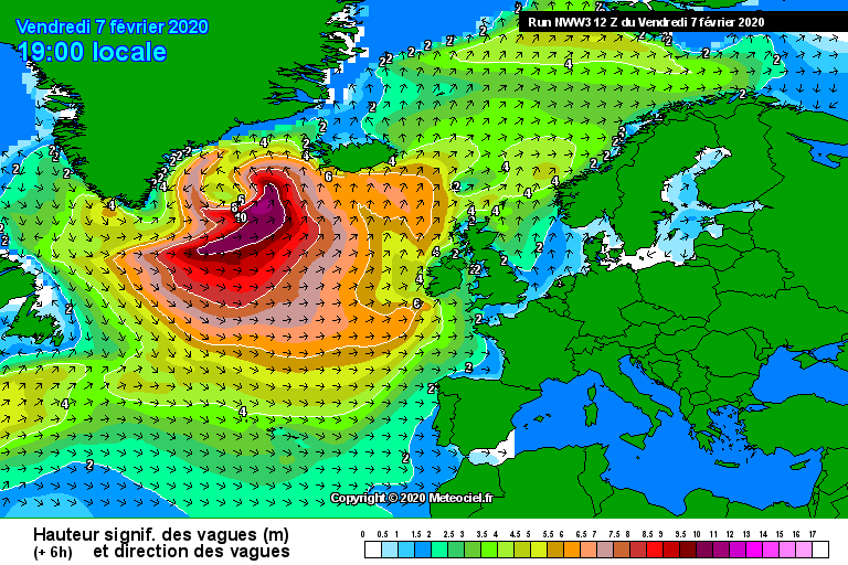
High seas and massive waves hitting all Atlantic coastal counties over the weekend and next week
JET STREAM
Storm Ciara is forecast to be a vigorous Atlantic storm system with an expansive wind-field. Numerical Weather Prediction Models project the centre of the storm to track close to northern Scotland with a minimum central pressure of around 940hPa at lunchtime Sunday.
The change will occur as very cold air sweeps out of Canada into the North Atlantic creating a sharp temperature contrast in the atmosphere over the ocean. This temperature contrast will result in the intensification of the jet stream over the North Atlantic, which will drive vigorous areas of low pressure towards Ireland.
The animation below shows the evolution of the jet stream over the coming days.
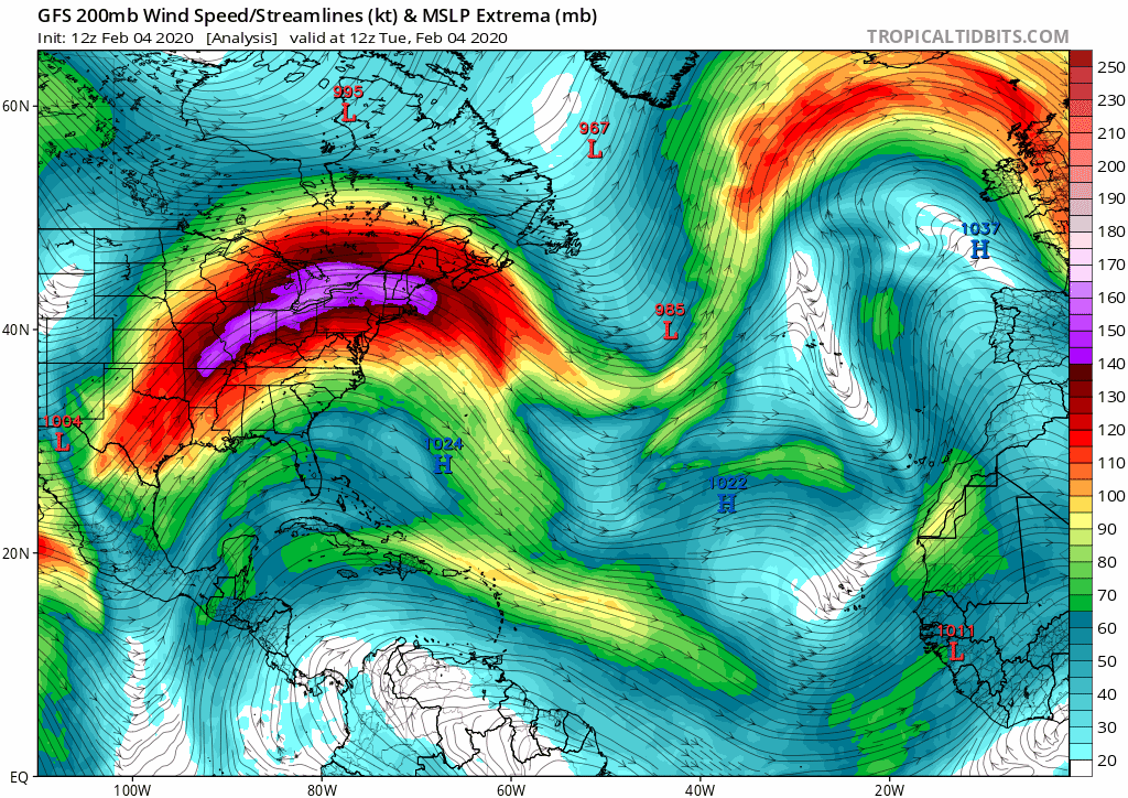
Intensification of the jet stream over the North Atlantic, which will drive vigorous areas of low pressure towards Ireland.
To answer some questions people have asked over the last few hours
Will there be a red wind warning?
At present looking at the latest models I would say no the highest level warning for wind will be a orange which is already in place for Saturday for Donegal, Mayo & Galway with another Orange warning likely to be issued on Saturday for Sunday as storm ciara hits, I would also expect many more counties to come under a Orange warning on Sunday if not a nationwide Orange warning.
Will storm Ciara be a Hurricane?
No storm Ciara will not be a hurricane as its not possible to get hurricanes this far north as the water is not warm enough to hold onto there hurricane characteristics. You can get Hurricane force winds this far north but the talk going around at the minute of Ciara been as strong as a Category 3 or 4 hurricane is nonsense and scaremongering.
Will there be snow this weekend?
Yes and no much of the precipitation that falls over the weekend will be of rain with any snow confined to the higher mountain peaks over the weekend. On Saturday and Sunday there will be the risk of some hail showers with the risk of some thunderstorms with a increasing risk of hail and sleet on Sunday evening and night.
Monday, Tuesday and possibly Wednesday next week will see a colder air mass all the way from Canada over Ireland and this could bring falls of snow in some places but some rain, sleet and hail also, The risk to snow over low levels will be greater over the start of next week but still that is yet a long bit away in forecasting terms as snow is one of the hardest components compared to rain, hail and sleet to forecast with margins been so fine at times.
Will festivals and sporting events go ahead?
There is a good chance that some festival event and sporting event could be called of this weekend due to the strong winds and heavy rain.
GAA National leagues
For example Donegal is due play Galway in Letterkenny on Sunday with both the Men’s and women's senior football teams set to play in the afternoon. There is a risk this could be called of either due to a waterlogged pitch or strong winds which are set to peak around the same time. Other games like this could also be called of across Ireland especially across Ulster, Connacht and west Munster.
That is it for this update folks if you found this informations useful please give this post a LIKE & SHARE on facebook or twitter
Kenneth from the Donegal Weather Channel


Click on the tabs below to view the new forecasts available under the forecast section.
2019 CALENDAR NOW ON SALE


2019 Calendar now on sale
You can now purchase the Donegal Weather Channel Calendar 2019. You can purchase the Calendar from the online store
All calendars will be posted out in the middle of November with only a limited amount available. Calendars can be purchased anywhere across the world.


The stunning Leitir Mhic An Bhaird (Lettermacaward) Donegal during May 2018

Vivid Rainbow from up on Breezy mountain South Donegal

I was in Albufeira Portugal I was waiting for the full moon to come up and it did not let me down.
The orange and red tints that the Moon sometimes take on rising and setting are caused by the particles in the Earth's atmosphere. When light (or more specifically, packets of light called photons) from an astronomical object passes through the Earth's atmosphere, it scatters off of particles in the latter.

What a unbelievable night and morning out storm chasing, These number of thunderstorms had to be the best in years as most of the lightning was CG bolts. I even manage to captures Two to three CG bolts in one shot.

One of the most beautiful views of Slieve league From sea and got some nice photos.
Photos from this angle I have not seen yet and it was wonderful to finally capture that moment.