
Met Eireann issue Status Orange wind warning for all of Ireland and a Red warning for all Irish coastal waters


Issued 13:00, Saturday, 8th February, by Evelyn Cusack, Head of Forecast Division and Eoin Sherlock, Head of Flood Forecast Division.
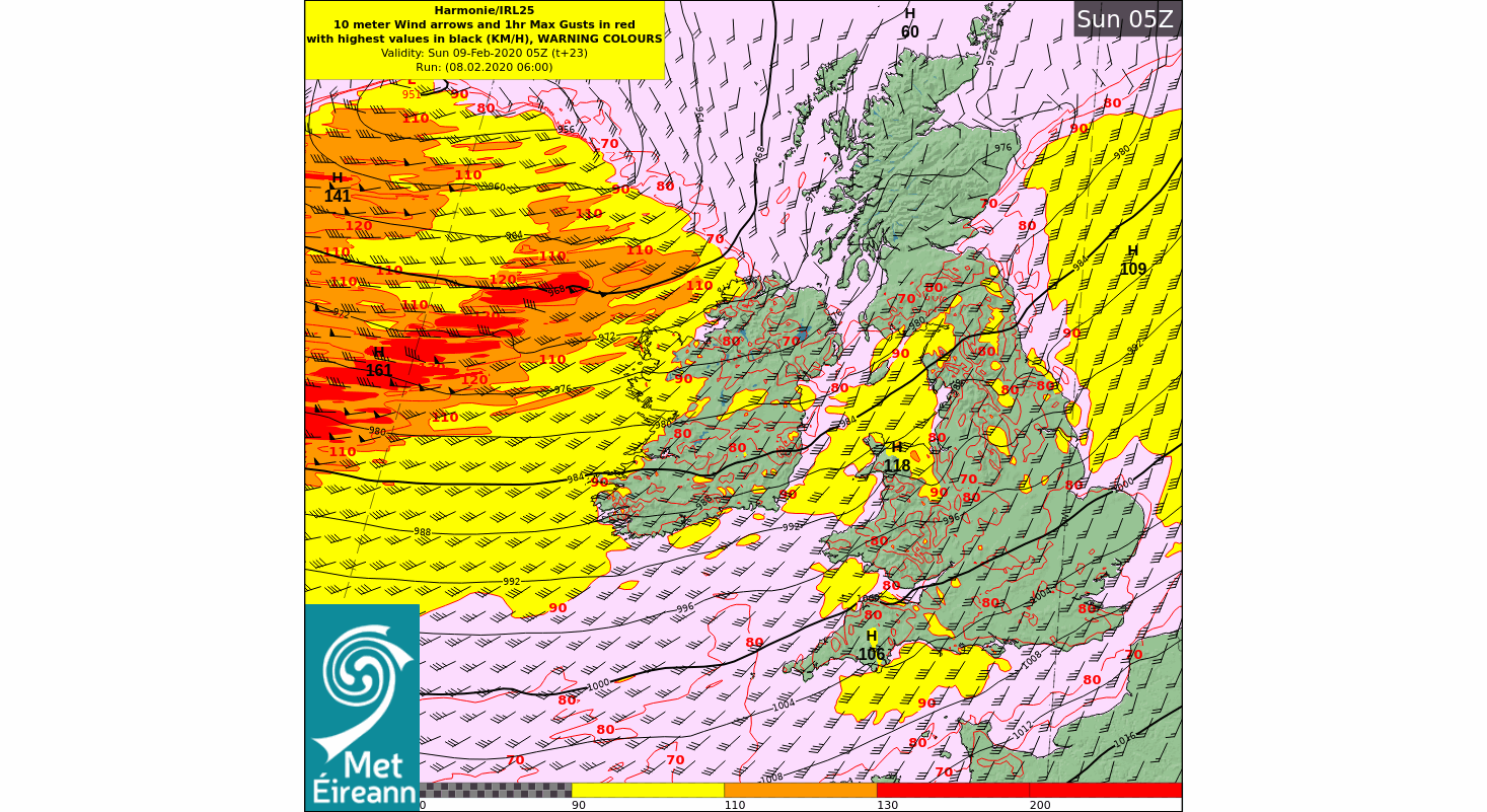
Storm Ciara will pass to the north of Ireland on Sunday. It will bring extremely windy and in places stormy conditions during the morning. Southwest winds will reach gale to strong gale force in strength with damaging gusts likely.
These gusts will affect parts of the country not normally impacted by such strong winds. Gusts will typically range between 100-130 km/h but they may exceed 140 km/h locally ( see animation below).
Continues below


Flooding Issues:
We are in a period of Spring Tides and these will coincide with very high seas which will start today Saturday and will continue into next week.
The combination of Spring Tides, high seas and extremely winds or stormy conditions will result in a significant risk of coastal flooding especially along northwestern and western coasts. This risk will persist into the middle of the coming week.
Storm Ciara will also bring very wet conditions with localised flooding possible as intense falls of rain spread across the country with some embedded thunderstorm activity.
Wintry weather
As Storm Ciara moves away on Sunday colder air is introduced over Ireland. This will bring scattered wintry precipitation later on Sunday night. The risk of snowfall increases as we move into the coming week. While snow showers may occur anywhere they will occur chiefly in parts of the north and west.
Kenneth from the Donegal Weather Channel


Click on the tabs below to view the new forecasts available under the forecast section.
2019 CALENDAR NOW ON SALE


2019 Calendar now on sale
You can now purchase the Donegal Weather Channel Calendar 2019. You can purchase the Calendar from the online store
All calendars will be posted out in the middle of November with only a limited amount available. Calendars can be purchased anywhere across the world.


The stunning Leitir Mhic An Bhaird (Lettermacaward) Donegal during May 2018

Vivid Rainbow from up on Breezy mountain South Donegal

I was in Albufeira Portugal I was waiting for the full moon to come up and it did not let me down.
The orange and red tints that the Moon sometimes take on rising and setting are caused by the particles in the Earth's atmosphere. When light (or more specifically, packets of light called photons) from an astronomical object passes through the Earth's atmosphere, it scatters off of particles in the latter.

What a unbelievable night and morning out storm chasing, These number of thunderstorms had to be the best in years as most of the lightning was CG bolts. I even manage to captures Two to three CG bolts in one shot.

One of the most beautiful views of Slieve league From sea and got some nice photos.
Photos from this angle I have not seen yet and it was wonderful to finally capture that moment.