
Farming Weather Forecast - 7 day rainfall forecast outlook for Ireland 27th June 2021

Weekly Rainfall forecast outlook updated Sunday 27th June 2020
Rainfall amounts over the week gone by where below average for many areas of Ireland apart from the northwest and north of Ireland where they were slightly above normal and normal across the parts of the east and northwest Connacht. Amounts range from trace 7.7mm to 24mm.
The most rainfall was recorded along western and northwest coastal areas during the week
The Highest amount of rainfall was at Met Eireann Weather Station at Malin Head Donegal with 24mm.
The least amount of rainfall was at Met Eireann Weather Station at Valentia, Kerry with 3.5mm.
The southwest south, southeast and midlands were the driest parts of Ireland in the last 7 days
The west and northwest received wettest weather over the last 7 days
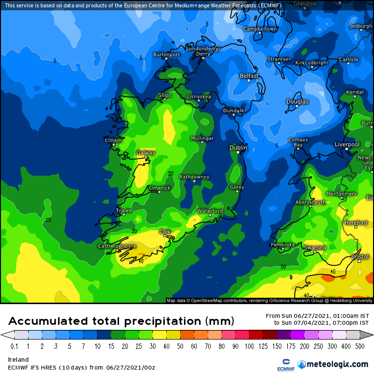
Rainfall amounts over the coming 7 days area expected to be below average with mainly dry weather until Friday with some uncertainty after this period. The lowest rainfall amounts this week look set to be across the northwest, north and west or Ireland. There is indications that across parts of Munster and Leinster rainfall amounts may be above average with due to the latest ECMWF models showing heavy thundery showery Friday, Saturday and Sunday next weekend.
The below rainfall forecast for the week ahead is based of the (European weather forecast model (ECMWF))

Monday 28/6/21
Monday will be a dry day across Ireland with no rainfall expected across the country. The day is set to see a lot of sunshine especially in the northwest and west of the country where these will be best. Rainfall amounts areas expected to be 0mm and under 1mm in parts of the southeast where there will be the slight risk of a shower.

Possible rainfall amounts on Monday
Tuesday 29/6/21
Again Tuesday will be a dry day across much of the country apart from the southeast coast where there will be the slight risk of a shower over the later afternoon and evening. The day again will see nice sunny spells for many but there are some indications it will become a little cloudier across northern, northwestern and west counties during the later afternoon and evening. Rainfall amounts of 0mm and under 1mm.

Possible rainfall amounts on Tuesday
Wednesday 30/6/21
Wednesday again is forecast to be another dry day across Ireland with bright and sunny spells but some cloud around also. There may be the slight risk of a few isolated showers in some southern coastal counties but overall mainly dry countrywide. Rainfall amounts of 0mm and under 1mm.

possible rainfall amounts on Wednesday

Thursday 1/7/21
Thursday may see some showers around in places especially in the eastern and southern half of Ireland where there may be the risk of a few thundery one in the later afternoon and evening. The day will also see bright and sunny spells with the best of the west across the west and north of Ireland. Rainfall amounts across the north and west of Ireland will range between 0mm to under 1mm across parts of Munster and Leinster rainfall amounts will range between 2mm to 5mm but maybe higher in places there locally if any thunderstorms do manage to form which can give locally heavy downpours.

possible rainfall amounts on Thursday
Friday 2/7/21
There is some uncertainty on the forecast on for Friday as some models show the risk of thunderstorms again in places with many area staying dry and warmer with sunny spells but the ECMWF model which is used by Donegal Weather Channel for the weekly rainfall forecast as a band of rain moving into the south of Ireland on Friday afternoon slowly extending northwards over the afternoon and evening however it has Ulster, Northern Connacht and northern Leinster staying dry until night time and some parts of Ulster dry until Saturday morning. The latest outlook below on the Chart shows the expected rainfall amount over the 24 hours period but this is subject to change. It currently has Ulster, North Connacht & north Leinster receiving 0mm to under 1mm on Friday but further south across Munster between 10mm to 30mm.

possible rainfall amounts on Friday
Saturday 3/7/21
The latest outlook for Saturday is for the risk of heavy thundery showers across parts of Ireland with the ECMWF model showing the greatest risk of across Munster and Connacht. There may be the risk of spot or flash flooding over the day. The latest model update shows some areas receiving up to 20m of rain but this will mostly likely change over the week when we get closer to this time period and the forecast becomes more certain.

possible rainfall amounts on Saturday
Sunday 4/6/21
Again the risk of thunderstorms will be possible next Sunday going by the latest ECMWF model outlook. The risk in this update is greatest across the west and northwest but this is likely to change over the coming days as we get closer to this time period.

possible rainfall amounts on Sunday
WEEKLY TEMPERATURE FORECAST
This week and next weekend will see temperatures in the high teen to mid 20s with above normal temperatures expected across a bulk of Ireland. Across the northern, northwestern and western coastal counties temperatures will be normal to just below there due to a northerly breeze but this will change on Thursday with temperatures also increasing in these areas as wind turn more easterly.
WEEKLY RAINFALL AMOUNTS EXPECTED BY PROVINCES
ULSTER
Rainfall amounts across Ulster this week will range between 4mm to 20mm with much of that rain forecast next weekend so overall it will be a dry week across Ulster up until then with the rainfall amounts possibly been lower than 20mm. The wettest part of Ulster is expected in the southwest of the provenance next weekend
CONNACHT
Rainfall amounts across Connacht will range between under 5mm in some areas to 40mm with again much of that rainfall forecast over the later stages of Friday and next weekend. There is a good chance that amounts will be lower than the forecast 40mm when we have a clearer idea of next weekend forecast at the start of next week
MUNSTER
Munster is forecast to see the largest rainfall amounts next week with the bulk of that rain expected as early as Friday evening and over over next weekend with rainfall amounts of 10mm to 50mm highest amounts across the mountains of cork and Kerry. But again rainfall amounts may be lower than forecast at present dur to uncertainty from Friday onwards.
LEINSTER
Leinster is set to be largely dry over the week apart from the slight risk of a few isolated showers in the south of Leinster. Rainfall amounts are forecast between 5mm to 20mm but again with the uncertainty in the forecast from Friday onwards these amounts may be lower when we have a better picture of that timeframe.
WEEKLY RAINFALL AMOUNTS
LATEST NEWS


