
Farming Weather - 7 day rainfall forecast outlook for Ireland 19th June 2021

Weekly Rainfall forecast outlook updated Saturday 19th June 2020
Rainfall amounts over the week gone by where well below average across much of Ireland. Amounts range from trace 0.8mm to 18mm.
The most rainfall was recorded along western and northwest coastal areas during the week
The least amount of rainfall was at Met Eireann Weather Station at Dublin Airport with 0.8mm.
The east and South were the driest parts of Ireland in the last 7 days
The west and northwest received wettest weather over the last 7 days
Over the next week rainfall amounts will be be near average across Ireland with the most rain expected west, northwest and southeast
The below rainfall forecast for the week ahead is based of the (European weather forecast model (ECMWF))

Sunday 20/6/21
Some showery weather is expected on Sunday morning across Ireland however across the east and northeast drier weather will develop with some sunshine. It will remain cloudy elsewhere with the risk of some showery conditions but it will turn drier from the north through the later afternoon. During Sunday evening rain will clear most area but linger in parts of the south east. There will be the slight risk of a isolated thunderstorm or two in parts of the northwest & west for a time in the afternoon. Rainfall amounts highest in the northwest, west and south with between 2mm to 6mm
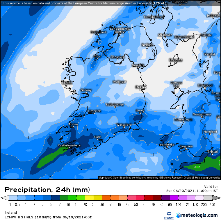
Possible rainfall amounts on Sunday
Monday 21/6/21
Monday will be a largely dry day across Ireland with good bright and sunny spells. There will be the small risk of a shower or two in parts of the eastern and northern half of Ireland mainly.

Possible rainfall amounts on Monday
Tuesday 22/6/21
A mainly cloudy day on Tuesday with some showery weather and drizzle highest rainfall amounts will be across the northern half of Ireland. Parts of Munster and Leinster will remain dry over the day

possible rainfall amounts on Tuesday

Wednesday 23/6/21
Wednesday looks set to start of with some showery rain moving across the country but it looks set to turn drier over the afternoon and evening from the west with a mainly dry day come the later afternoon stages. Rainfall amounts will be highest in the northwestern and western coastal counties but even at that rainfall amounts will be generally low. around 5mm to 10mm possible west Donegal with 2mm to 5mm expected elsewhere.

possible rainfall amounts on Wednesday
Thursday 24/6/21
Thursday is looking like a very wet day nationwide with a spell of heavy rainfall moving across the country. The latest indications are for the heaviest of that rain to be across western half of Ireland with some places possibly receiving up to 20mm to 30mm. In General rainfall amounts across Ireland will range between 5mm to 20mm with the least amounts across south and southeastern coastal areas. Some Changes are likely in the forecast models between now and next Thursday and D.W.C will have daily updates on for Thursday on our National forecast section of the website.

possible rainfall amounts on Thursday
Friday 25/6/21
Further showers are forecast for Friday across Ireland with the risk of isolated thunderstorms. However there is some uncertainty with this period as the European model was showing drier and warmer conditions heading into next weekend. The American model was also showing a drier and warmer pattern heading into next weekend. The attached chart below is the latest outlook from the ECMWF model.

possible rainfall amounts on Friday
Saturday 26/6/21
Again some uncertainty heading into next Saturday with the latest ECMWF model showing the risk of some rain.

possible rainfall amounts on Saturday
WEEKLY RAINFALL AMOUNTS EXPECTED BY PROVINCES
ULSTER
Across much Ulster rainfall amounts are expected to be average this coming week. Highest amounts will be across west Ulster mainly across Donegal over the higher ground areas with between 20mm to 50mm highest amounts across west Donegal . Across the rest of Ulster amounts will range between 15mm to 30mm.
CONNACHT
Rainfall amounts across Connacht this week will range between 15mm to 50mm with the highest amounts across west Connacht
MUNSTER
Away from west Munster rainfall amounts are expected to be average or just below this coming week. Highest amounts will be across west Munster mainly across west Kerry over the higher ground areas with between 20mm to 40mm. Across the rest of Munster amounts will range between 15mm to 30mm lowest amounts in the east Munster.
LEINSTER
rainfall amounts will be between 5mm to 10mm. Highest amounts across the mountains there.

LATEST NEWS


