
Will there be a storm at the weekend and is there snow on the way


It has been a very unsettled month so far this February with two storms battering Ireland and the UK bringing strong winds and heavy rain with some major flooding in places. It also been a month where there has been some falls of snow also but it nothing unusual for the time of year.
Between the 1st of February and the 16th of Ireland experienced more than twice the normal amount of rainfall per day during the first sixteen days of February according to official precipitation figures published on the Met Éireann
Met Éireann has 25 synoptic weather stations located all around the country measuring rainfall, temperature, wind speed, sunshine, air pressure and other weather variables on an hourly basis.
They are located in places like Malin Head, Mace Head, Valentia Island, Sherkin Island, Shannon Airport, Dublin Airport and many more.
Continues below


The Met Éireann data shows large variations in average monthly rainfall amounts depending on where in the country the weather stations are located.
For instance the long-term average rainfall for February - established over a thirty year period - ranges from a low of 48.5 millimetres at Casement Aerodrome in Co Dublin to a high of 126.5 millimetres of rain at Newport in Co Mayo.
However, taking all of Met Éireann's 25 weather stations together shows the typical or average amount of rain recorded per station during the month of February is 82.8 millimetres for the whole month. That works at about 2.95 millimetres of rain per day per station during February.
It highlights precisely why there are growing concerns in rural and other areas about the impact of local and regional flooding in the face of further forecasts of poor weather over the coming weeks.
The Met Éireann figures also show that Co Mayo has experienced the highest level of rainfall so far this month.
Its weather station at Claremorris has recorded 149.5 millimetres of rain up to and including yesterday. This is the highest rainfall in the country so far this month. It is closely followed by Newport also in Co Mayo with 146.5 millimetres, and Knock Airport with 139.5 millimetres.
Continues below
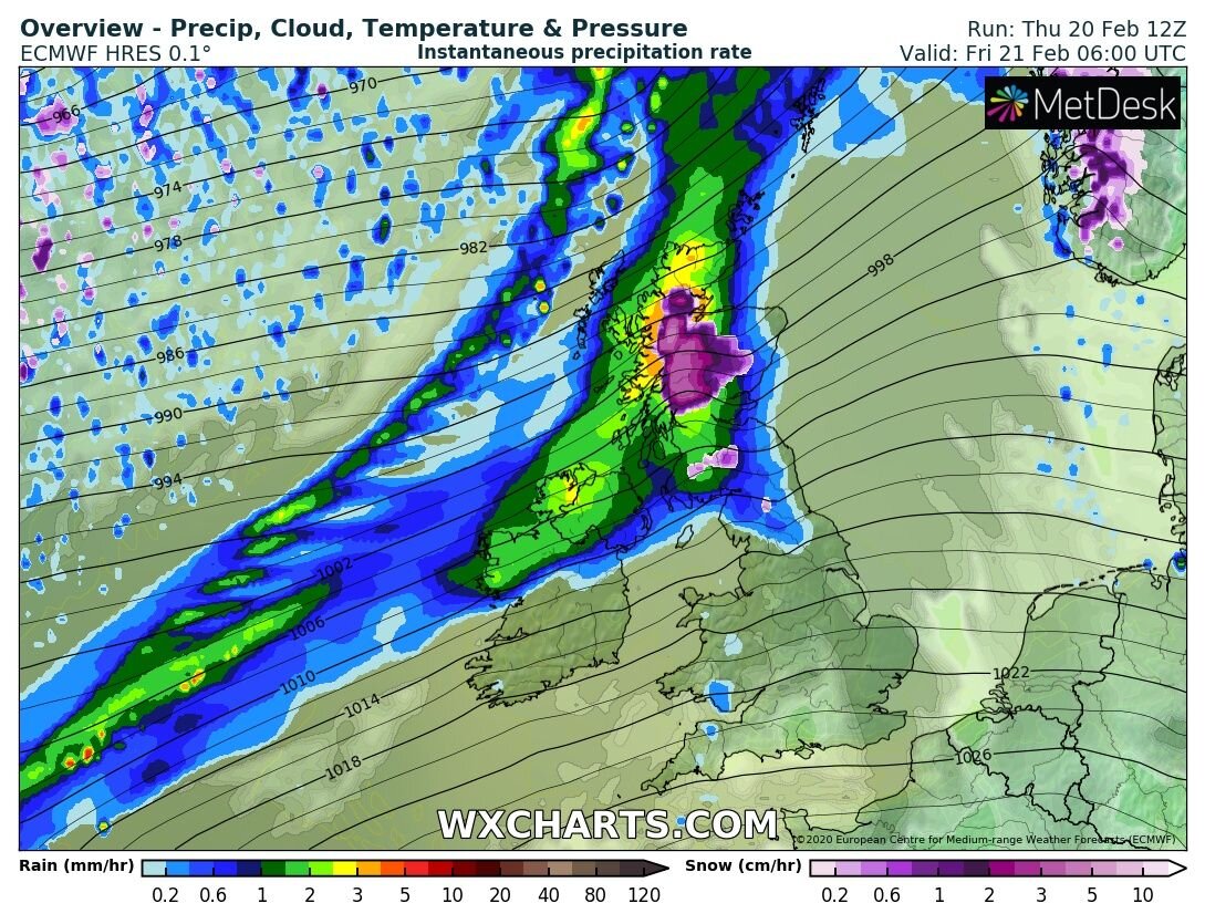
On Friday a area of of low pressure which is centered over Iceland will bring windy weather across western, northwestern and northern coastal counties of Ireland with winds gusting between 80 to 100km/h and a slight risk of localised coastal flooding. It will also be a very wet day on Friday for much of Ireland with very heavy rainfall across the west, northwest and north with the risk of localised flooding. Status yellow weather warnings have been issued for both wind and rain.
Below images show that heavy rain moving into the northwest on Friday morning and spreading southeast over the day with very heavy falls across the northwest

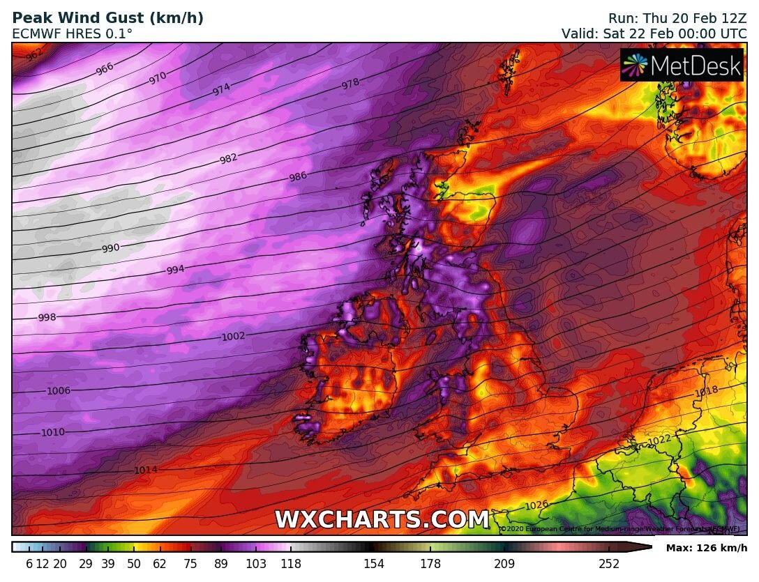
Below images show windy conditions on Friday morning into Saturday morning across mainly western and northern areas

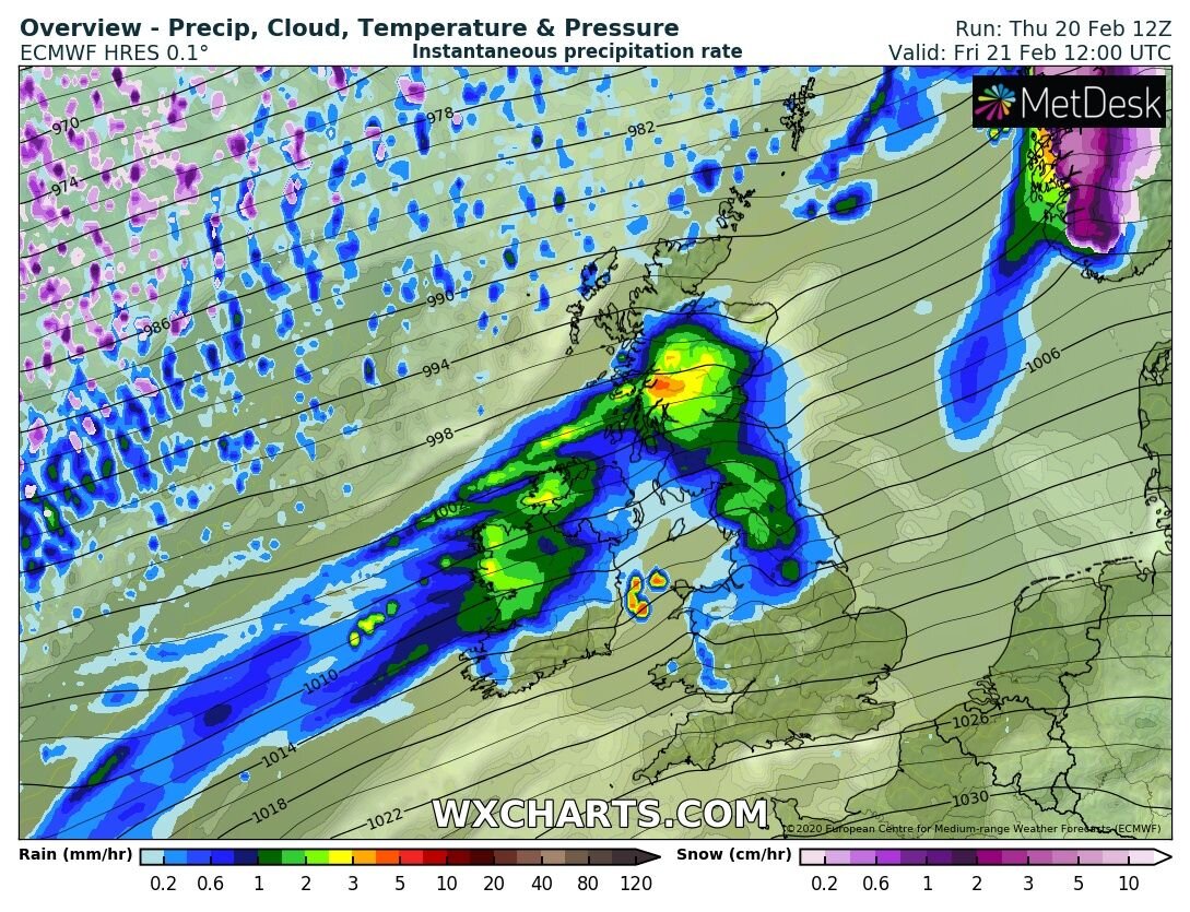
That rain will then clear to the east on Saturday morning with blustery and showery weather following behind from the west. Some of the showers on Saturday may turn to hail and sleet and even snow for a time across the northwest and north but not accumulations are expected over lower levels.
Continues below
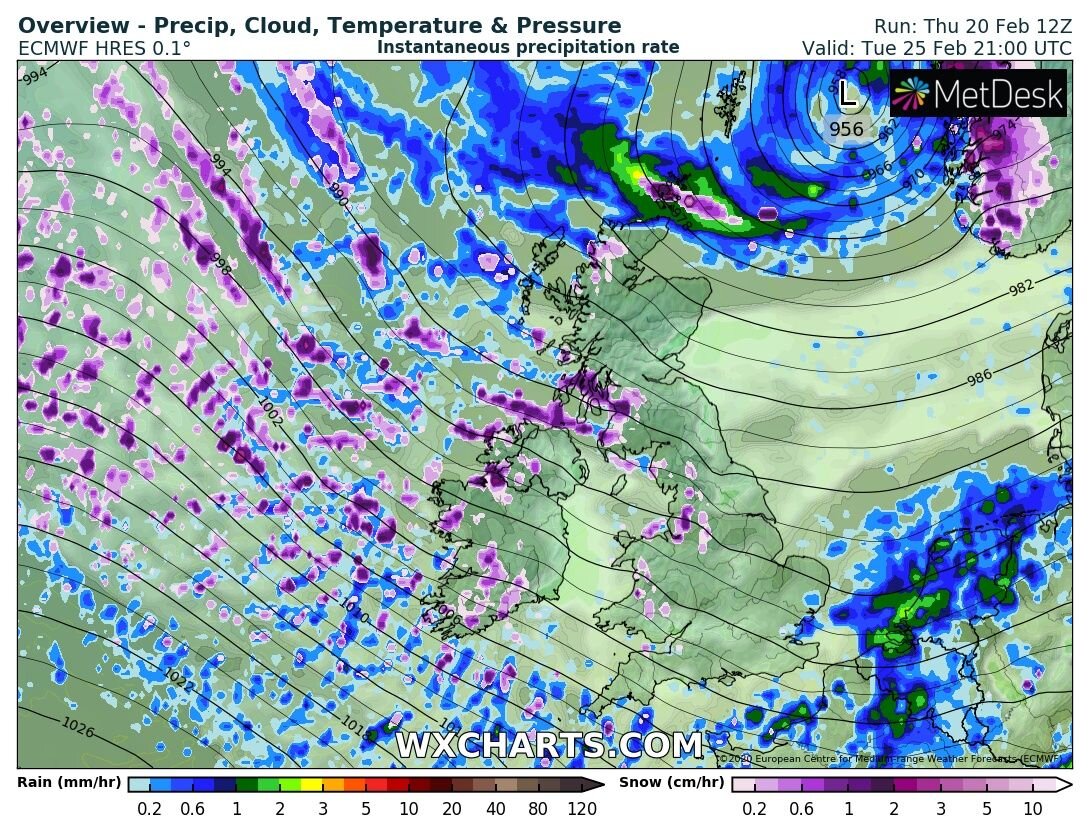
STORM WATCH
A deep area of low pressure is currently showing to pass out to the northwest of Ireland on Sunday night into Monday morning with some windy conditions but at the moment both the ecmwf and gfs models show much the same in what path the storm will take but it would not take much for this to shift a little more to the west or south for Ireland to see the full force of this area of low pressure.
At present the most severe winds from this low will be over the north of Scotland and the storm could be named by the UK Met office in the coming days.
Sunday morning and much of the afternoon and evening looks rather settled ahead of this area of low pressure with some bright and sunny spells these best over Ulster in rather light winds or breezes.
Sunday night at around 00:00hrs latest models have the center of the deep area of low pressure well of the west coast of Ireland but a band of light or rain associated with the low will move into the southwest of Ireland over the evening spreading to all areas late in the evening or overnight.

Area of low pressure of the west of Ireland midnight Sunday
The are of low pressure then looks set to track northeast wards towards northern Scotland with severe and damaging gusts over northern parts of Scotland on Monday evening and night

Area of low pressure of the northwest of Ireland dawn 06:00hrs Monday morning

Area of low pressure over the north of Scotland Monday evening and night with strong and severe damaging gusts
Going by the latest track of this are of low pressure wind warning would likely be issued for western, northwestern and northern counties Sunday night into Monday for Ireland with winds gusting between 90km/hr to 110km/hr. A status yellow wind warning will be likely and at this stage no orange wind warnings would be required unless the center of the storm tracked much closer to Ireland.
POSSIBLY TURNING COLDER FOR A TIME NEXT WEEK
As that area of low pressure passes of the northwest and north coast of Ireland on Sunday night and Monday much colder air then looks set to feed in for Tuesday and the middle of next week bringing with it colder air temperatures with the risk of Icy conditions. There would also be the risk of wintry falls of hail, sleet and snow with the risk of Thunderstorm activity also.
Both the two main weather models the ECMWF and GFS both show this outcome and also show the colder weather stating until the end of next week before turning warmer again next weekend.
On Tuesday the latest model runs from both model show showers starting of as rain, sleet and hail but over Tuesday evening/night these turning increasingly to snow for some lower level areas also.
The outlook over the rest of the week is for the weather to remain unsettled and on the colder side with the risk of further wintry falls at times.
Highest risk are at present for snowfall on Tuesday would be the west, northwest and north of Ireland.
This is something I will update again on over the week as well as that area of low pressure.


Click on the tabs below to view the new forecasts available under the forecast section.
2019 CALENDAR NOW ON SALE


2019 Calendar now on sale
You can now purchase the Donegal Weather Channel Calendar 2019. You can purchase the Calendar from the online store
All calendars will be posted out in the middle of November with only a limited amount available. Calendars can be purchased anywhere across the world.


The stunning Leitir Mhic An Bhaird (Lettermacaward) Donegal during May 2018

Vivid Rainbow from up on Breezy mountain South Donegal

I was in Albufeira Portugal I was waiting for the full moon to come up and it did not let me down.
The orange and red tints that the Moon sometimes take on rising and setting are caused by the particles in the Earth's atmosphere. When light (or more specifically, packets of light called photons) from an astronomical object passes through the Earth's atmosphere, it scatters off of particles in the latter.

What a unbelievable night and morning out storm chasing, These number of thunderstorms had to be the best in years as most of the lightning was CG bolts. I even manage to captures Two to three CG bolts in one shot.

One of the most beautiful views of Slieve league From sea and got some nice photos.
Photos from this angle I have not seen yet and it was wonderful to finally capture that moment.