
Warnings issued ahead of heavy & possible disruptive snowfall for Saturday morning

Across the south and west of Ireland this morning and this afternoon snow has been falling giving some accumulations in places especially for inland parts of Munster and west Connacht as that frontal system continues to push northwards overnight but the latest indication is for it to die out over North Connacht, south Ulster and around north Leinster.
Some parts of north Leinster may not see any snowfall at all even though they are under a Met Eireann snow and ice warning.
Friday night and Saturday morning is set to be a more interesting day with a large risk of snowfall and bigger amounts.

Latest on todays snowfall risk. Ulster Much of Leinster and north Connacht staying mostly dry today at least until this evening and tonight
TIMES
Thursday 4pm to 9pm
During the evening and early stage of the night falls of snow are expected across Much of Connacht and east Leinster, across Munster areas well inland still seen snowfall but nearer to the coast it will be a mix of rain and sleet.
Thursday 9pm to Friday 2am
Snow turning to rain across much of Munster at this stage but still snow across Connacht with that band of snow pushing eastwards over west Leinster but possibly fading out before reaching east Leinster
Friday 2am to 8am
Snowfall across Leinster, south Ulster & north/east Connacht with rain across southern and western parts of Munster.

All attention then turns to Friday night into Saturday morning which is now looking like heavy snowfall will fall across parts of the northwest, north with the risk of some significant accumulations there. Some accumulations also across parts of Leinster and Connacht.
Below you can see the latest 4 model updates from the ECMWF, GFS, ICON & ARPEGE model
Note that the ARPEGE, ECMWF & ICON are all high resolution models and give a better output that the GFS at a shorter range.
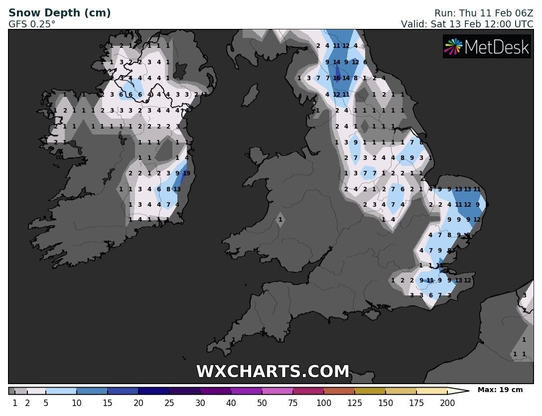
GFS MODEL

ECMWF MODEL

ICON MODEL

ARPEGE MODEL


Another Atlantic frontal system will move in across Ireland on Friday night and Saturday morning with colder air sitting across the northwest, north and east this rain will turn to sleet and snow as it hit the colder air and freezing temperatures giving snow accumulations of 0cm to 5cm epically across Ulster and eastern Connacht ( Sligo & Leitrim)
The latest model outputs today show disruptive Snowfall across parts of the northwest and north of Ireland for areas like Donegal, Sligo, Leitrim, Cavan, Monahgan, Derry, Fermanagh, Tyrone & Armagh with some areas within these counites possible receiving between 5cm to 10cm of snow on Saturday morning. Last night Donegal Weather Channel issued a Snow risk alert for much of Leinster, Ulster and east Connacht. As is said i will update this either tonight or Friday morning when the finer details are able to be pin pointed.
On Saturday afternoon and evening rain will then turn back to rain with a quick thaw and the risk of flooding.

Further updates and changes to this risk areas may be changed over the coming 24 hours when the finer details can be narrowed down.
EARLY WEATHER WARNINGS ISSUED
Met Eireann and the UK met office have issued warning in advance of the snowfall on Friday night into Saturday morning. Status Yellow weather warnings are currently in place (see warnings below) . Some of the forecast model show the potential for the snowfall to be disruptive especially across the northwest and north where a orange and amber warning may be issued on Friday due to the amounts.
Status Yellow - Snow/Ice warning for Connacht, Leinster, Cavan, Monaghan and Donegal
Met Éireann Weather Warning
Snow accumulations of 5 cm possible (more on higher ground), accompanied by fresh to strong southeast winds.
Valid: 02:00 Saturday 13/02/2021 to 12:00 Saturday 13/02/2021
Issued: 12:00 Thursday 11/02/2021
Yellow - Snow and Ice Warning for Antrim, Armagh, Down, Fermanagh, Tyrone, Derry
UK Met Office Weather Warning
Snow is likely to spread east during Saturday with some accumulations in places and icy stretches. Potential for disruption to travel.
Valid: 00:00 Saturday 13/02/2021 to 23:59 Saturday 13/02/2021
Issued: 11:12 Wednesday 10/02/2021
Updated: 10:11 Thursday 11/02/2021
You can find all the latest weather warnings and forecasts by downloading our app from the google play store by clicking below

LATEST NEWS


