
UPDATE - Snow for places Sunday night for a time and stormy conditions looking less likely

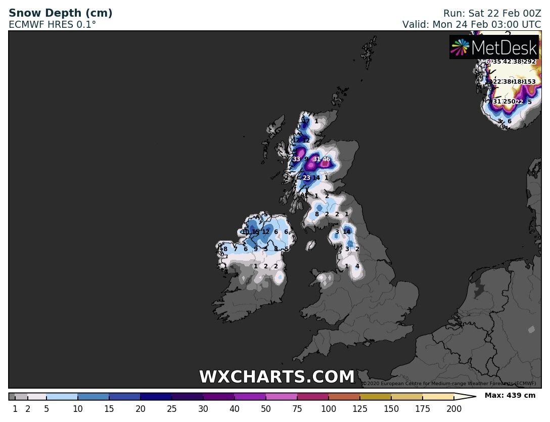
Possible snow accumulations on Sunday night
The latest weather models this Saturday afternoon have continue show the risk of snow in parts on Sunday night as a band of precipitation moves in from the Atlantic Sunday evening and spreads nationwide on Sunday night.
Continues below


The latest ECMWF, GFS, ICON, HIRLAM & ARPEGE model shows a band of rain moving into the southwest of Ireland on Sunday evening associated with a area of low pressure of the west of Ireland. Overnight this rain spreads north eastwards across Ireland and looks set to turn wintry with heavy falls of sleet and snow across parts of the north Connacht, Ulster and north Leinster where there will be the risk of possible snow accumulations occurring as this band of precipitation spreads northwards on Sunday night and early Monday morning. The rain will turn to sleet and snow in some places for a time before turning back to rain later in the night again
Below you can see this on the 5 models mentioned above


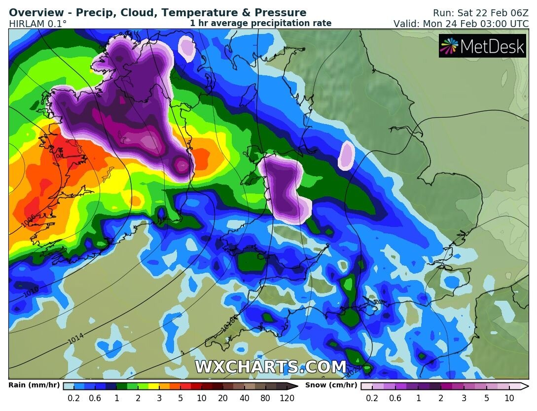
The precipitation then looks set to turn back to rain in parts of the west and north for a time on Monday morning there will be the ongoing risk of risk of spot and localised flooding . Elsewhere the precipitation will fall as rain with the the risk of spot and localised flooding.
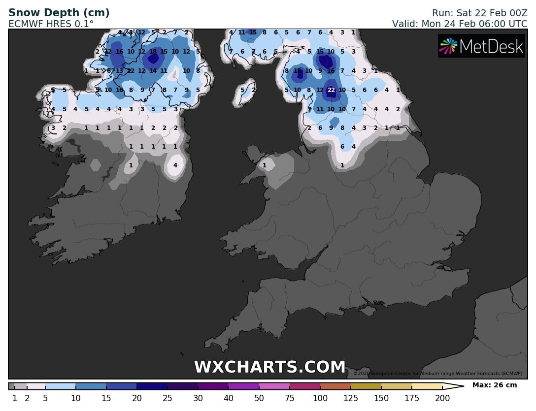
Possible snow accumulations over the north Connacht and Ulster on Sunday night and early Monday morning.
Continues below
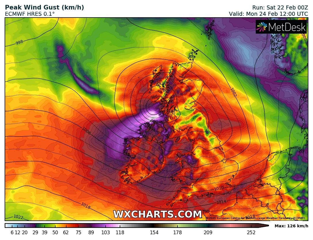
STORM WATCH MONDAY - STORM LOOKING LESS LIKELY
A area of low pressure which looked like it was going to move close to the northwest and north of Ireland given severe and damaging gusts across the northwest and north on Monday morning and afternoon has now downgraded and does not look severe but will be windy and gusty and it not likely to be a named storm below you can see the latest models runs show a downgrade.
Continues below
Weather warnings are still expected to be issued for Monday morning and afternoon for wind but at present the highest level warning would be a yellow weather warning for winds across western, northwestern and northern counties for winds gusting up to 110km/hr.
There is a outside chance that a orange warning could be issued for some northwestern counties for gusts up to 120km/hr but this would be a low chance and strongest winds occurring along exposed coastal areas.
Continues below
The reason for the downgrade on models on this area of low pressure this morning is due to the jet stream and what side of the jet the area of low pressure sits on.
To the north of the jet stream you have the cold side or colder air and to the south side of the jet stream you have the warmer side or warmer air.
The current models show the area of low pressure on the southern side of the jet stream which means it will not deepen as quick or rapidly.
If the area of low pressure was to sit on the colder side of the jet stream or northern side of the jet stream it would allow it to deepen very rapidly and undergo rapid cyclogenesis like it was showing on models on Friday which would give stronger and more severe winds.
Continues below
I will have further updates over the course of today and Sunday for any changes that may occur in the forecast and have further updates on the snow risk for Sunday night into Monday morning.
Kenneth from the Donegal Weather Channel


Click on the tabs below to view the new forecasts available under the forecast section.
2019 CALENDAR NOW ON SALE


2019 Calendar now on sale
You can now purchase the Donegal Weather Channel Calendar 2019. You can purchase the Calendar from the online store
All calendars will be posted out in the middle of November with only a limited amount available. Calendars can be purchased anywhere across the world.


The stunning Leitir Mhic An Bhaird (Lettermacaward) Donegal during May 2018

Vivid Rainbow from up on Breezy mountain South Donegal

I was in Albufeira Portugal I was waiting for the full moon to come up and it did not let me down.
The orange and red tints that the Moon sometimes take on rising and setting are caused by the particles in the Earth's atmosphere. When light (or more specifically, packets of light called photons) from an astronomical object passes through the Earth's atmosphere, it scatters off of particles in the latter.

What a unbelievable night and morning out storm chasing, These number of thunderstorms had to be the best in years as most of the lightning was CG bolts. I even manage to captures Two to three CG bolts in one shot.

One of the most beautiful views of Slieve league From sea and got some nice photos.
Photos from this angle I have not seen yet and it was wonderful to finally capture that moment.