
Update - Risk of heavy snowfall for parts of Ireland tonight for a time with flooding also


Possible snow accumulations on Sunday night
A band of rain will extend nationwide tonight with the risk of flooding with rainfall accumulations of between 20 to 25mm, with higher totals possible in upland areas.
As the ground is saturated at the moment and river levels are elevated the combined effect of rainfall and snow melt may lead to some localised surface and river flooding.
Continues below


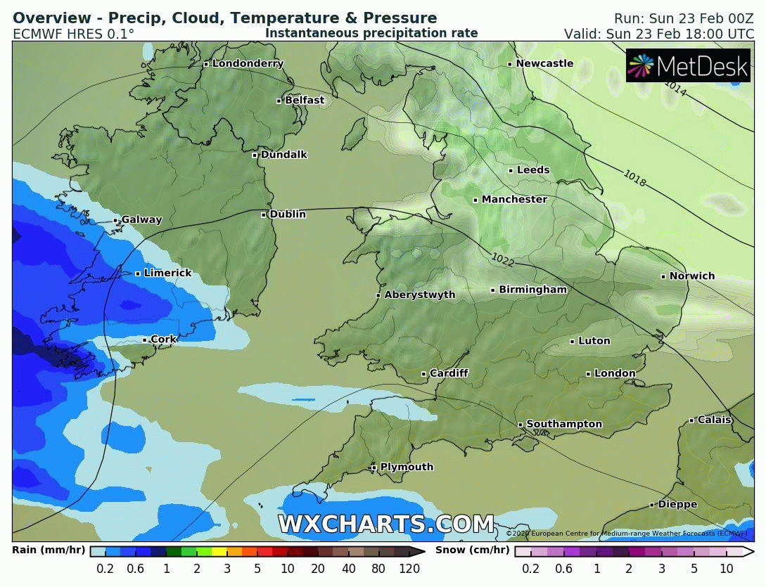
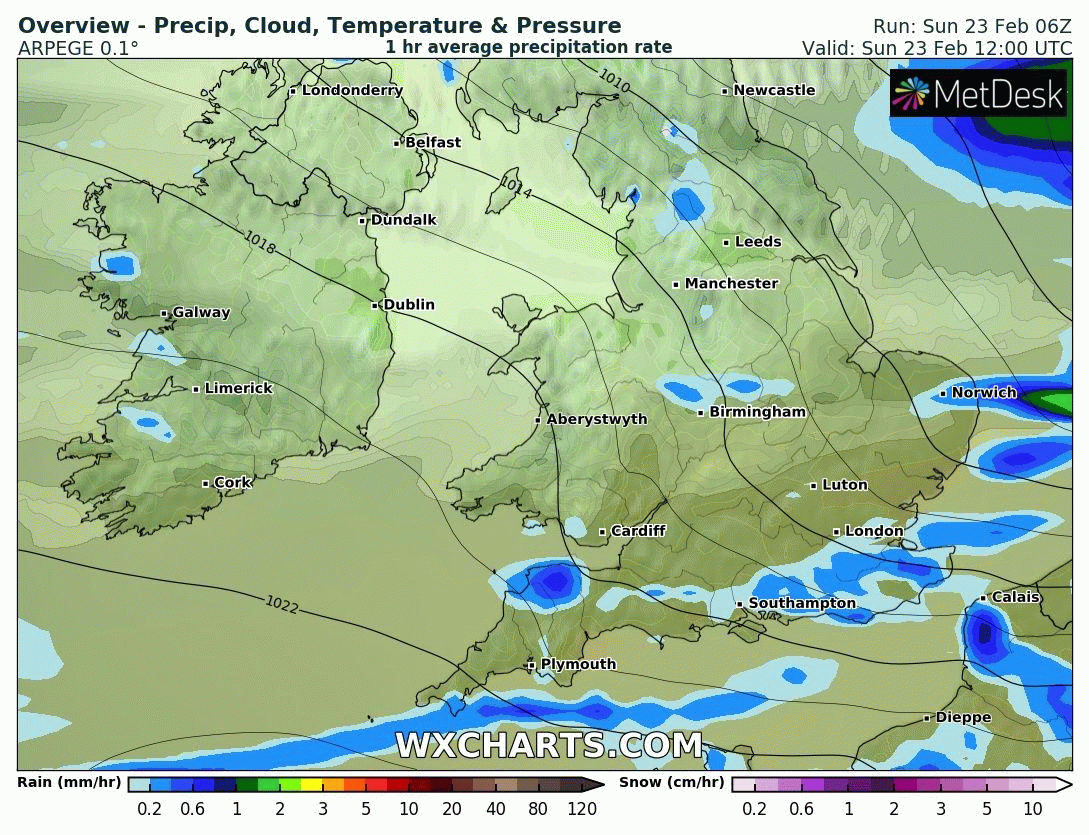
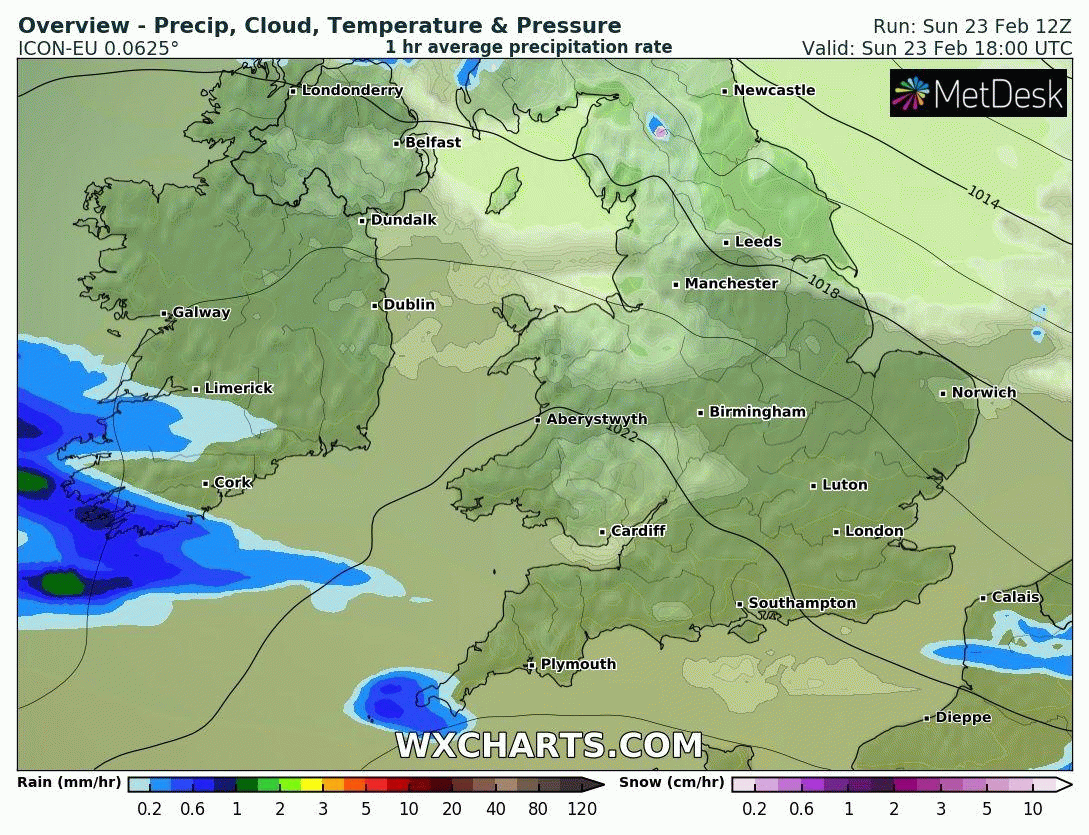
The latest ECMWF, GFS, ICON, HIRLAM & ARPEGE model shows a band of rain moving into the southwest of Ireland on Sunday evening associated with a area of low pressure of the west of Ireland. Overnight this rain spreads north eastwards across Ireland and looks set to turn wintry with heavy falls of sleet and snow across parts of the north Connacht, Ulster and north Leinster where there will be the risk of possible snow accumulations occurring as this band of precipitation spreads northwards on Sunday night and early Monday morning. The rain will turn to sleet and snow in some places for a time before turning back to rain later in the night again
Below you can see this on the 5 models mentioned above
Purple and pinks show areas where sleet and snowfall is likely


The precipitation then looks set to turn back to rain in parts of the west and north for a time on Monday morning there will be the ongoing risk of risk of spot and localised flooding . Elsewhere the precipitation will fall as rain with the the risk of spot and localised flooding.

Possible snow accumulations over the Connacht, Ulster and north Leinster tonight and early Monday morning.
Continues below
STATUS YELLOW - RAINFALL & SNOW/ICE WARNING

STATUS YELLOW - RAINFALL & SNOW/ICE WARNING FOR CONNACHT, CAVAN, MONAGHAN, DONEGAL, DUBLIN, KILDARE, LAOIS, LONGFORD, LOUTH, WICKLOW, OFFALY, WESTMEATH, MEATH, CLARE, LIMERICK, TIPPERARY
UPDATE:
A spell of rain tonight into Monday morning will lead to accumulations of between 20 to 25mm, with higher totals possible in upland areas.
The rain is likely to be preceded by a period of sleet and snow in parts of Connacht, Ulster and north Leinster, with hazardous driving conditions for a time, before turning to rain later.
As the ground is saturated at the moment and river levels are elevated the combined effect of rainfall and snow melt may lead to some localised surface and river flooding.
Valid: 20:00 Sunday 23/02/2020 to 08:00 Monday 24/02/2020
Issued: 13:57 Sunday 23/02/2020
Warning issued by Met Éireann
STATUS YELLOW - RAINFALL & SNOW/ICE WARNING FOR NORTHERN IRELAND
An area of rain moving into Northern Ireland during Sunday night turns to sleet and snow during the early hours of Monday before turning back to rain again from the south during the course of the morning. The bulk of accumulations will be above 100 to 200 metres with a chance that above 200 metres some places may see 5 to 10 cm snow. At lower levels, snow cover will be patchier with small temporary accumulations and slushy deposits. During the afternoon, strong winds may then lead to some drifting of lying snow over hills and mountains.
Valid: 00:00 Monday 24/02/2020 to 02:00 Monday 24/02/2020
Issued: 10:16 Sunday 23/02/2020
Warning issued by Met Office UK
Continues below
I will have further updates over the course of today and tonight for any changes that may occur in the forecast a snow and ice warning could be issued today by Met Eireann even with the risk highlighted under the current rainfall warning in place.
Kenneth from the Donegal Weather Channel


Click on the tabs below to view the new forecasts available under the forecast section.
2019 CALENDAR NOW ON SALE


2019 Calendar now on sale
You can now purchase the Donegal Weather Channel Calendar 2019. You can purchase the Calendar from the online store
All calendars will be posted out in the middle of November with only a limited amount available. Calendars can be purchased anywhere across the world.


The stunning Leitir Mhic An Bhaird (Lettermacaward) Donegal during May 2018

Vivid Rainbow from up on Breezy mountain South Donegal

I was in Albufeira Portugal I was waiting for the full moon to come up and it did not let me down.
The orange and red tints that the Moon sometimes take on rising and setting are caused by the particles in the Earth's atmosphere. When light (or more specifically, packets of light called photons) from an astronomical object passes through the Earth's atmosphere, it scatters off of particles in the latter.

What a unbelievable night and morning out storm chasing, These number of thunderstorms had to be the best in years as most of the lightning was CG bolts. I even manage to captures Two to three CG bolts in one shot.

One of the most beautiful views of Slieve league From sea and got some nice photos.
Photos from this angle I have not seen yet and it was wonderful to finally capture that moment.