
Turning cold later Easter Sunday with snow showers in places on Monday and Tuesday

Very cold Arctic air to arrive later Easter Sunday. Image shows very cold upper air temperature.
After some lovely spring sunshine there is set to be a bug change over the next 24 to 48 hours as it turns much colder with a Arctic Blast of air and snow showers from Easter Sunday especially over the later stages of Sunday where we will see the change.

The weather is set to take a dramatic change at the end of the weekend as much cold conditions push down from the Arctic region with winds turning northerly in direction and Temperatures dropping below freezing with wintry showers Sunday Night, Monday and Tuesday.
Sunday morning and the early afternoon overall will not be all that bad with dry conditions in many areas with the best of any sunshine to the south and southeast of Ireland. However the morning will start of cold with frost with lows of -2C in places with the risk of fog also forming especially across western and northern areas where it will reduce visibility in some places.

Later Sunday afternoon and evening is when that change to mild to colder air will occur as a cold front moves down from the north with cloud also increasing. Overnight will be mainly dry away from on northern areas on Sunday but there will be some light on the rain in drizzle across parts of Ulster. Before dawn Monday morning that colder Arctic air really starts to dig in with showers then turning wintry with hail, sleet and snow showers across Ulster and North Connacht with mainly dry conditions elsewhere but alot of dry weather also across northern areas where showers will occur.

Latest Ecmwf model chart showing possible snow accumulations in mainly northern areas on Monday and Tuesday.
Overnight Monday and Tuesday there will be further showers these turning a little heavier and falling as snow in some places possibly giving some small temporary accumulations showers most Frequent across Ulster and North Connacht with mainly drier condations further south. The plus side is that many areas will see good sunshine on both Monday and Tuesday even in places where some showers will occur. It will feel much colder on Monday and Tuesday with temperatures between 4C to 7C falling lower in any areas that see some showers. Overnight temperatures will range between -5C to 2C with some areas seen a hard frost.

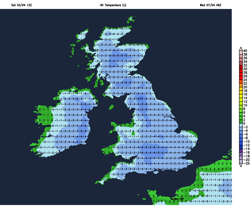
Temperature Forecast Monday Night Tuesday Morning
Temperature Forecast Tuesday Night and Wednesday morning
Gardeners and crop growers should be on alert as there will be damaging frosts.
Wednesday and Thursday will turn that bit mild with highs of 7C to 11C some rain and drizzle will effect mainly parts of the west and north with drier weather across the south and east where the best of any sunny breaks will be.
Next Friday and Weekend will see a mix of sunshine and showers with the slight risk of frost in some places.
You can find all the latest weather warnings and forecasts by downloading our app from the google play store by clicking below

LATEST NEWS


