
The northwest of Ireland looks set be one of the hardest hit areas by storm Ciara

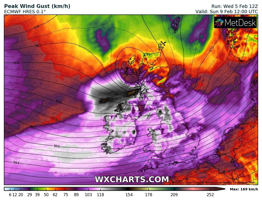
Latest ECMWF model shows the northwest been hit hard
The latest Ecmwf model this evening has Storm Ciara hitting Ireland on Sunday with this been a nationwide weather event.
The northwest of Ireland looks set to be hardest it as the center of the storm passes over northern Scotland which has a massive windfield on its southern flank.
Continues below


Winds nationwide on the latest ECMWF forecasting model show winds gusting between 90km/hr to 120km/hr nationwide with some strong to severe gusts.
The strongest winds look set to be across the southwest, west, northwest and north of Ireland where winds could gust between 110km/hr to 130km/hr and possibly stronger across Donegal, Sligo, Leitrim, Derry, Fermanagh, Tyrone and Antirm where gust of up to 140km/hr to 150km/hr could be possible particularly across exposed coastal areas in these counties.
Winds will increase on Sunday morning and peak around midday and over the early afternoon.
There will be a significant risk of coastal flooding across southwestern, western, northwestern and northern coastal areas on Sunday due to high sea, big waves, storm surge and high spring tides particularly across western, northwestern & northern coastal counties.
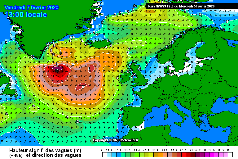
High seas and massive waves hitting all Atlantic coastal counties on Sunday
JET STREAM
Storm Ciara is forecast to be a vigorous Atlantic storm system with an expansive wind-field. Numerical Weather Prediction Models project the centre of the storm to track close to northern Scotland with a minimum central pressure of around 940hPa at lunchtime Sunday (see Figure Below).
The change will occur as very cold air sweeps out of Canada into the North Atlantic creating a sharp temperature contrast in the atmosphere over the ocean. This temperature contrast will result in the intensification of the jet stream over the North Atlantic, which will drive vigorous areas of low pressure towards Ireland.
The animation below shows the evolution of the jet stream over the coming days.
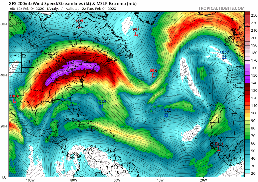
Intensification of the jet stream over the North Atlantic, which will drive vigorous areas of low pressure towards Ireland.
Flooding issues
The country will enter a period of Spring Tides this weekend. This will coincide with high seas, which are likely to affect coastal areas at first on Saturday but will continue into Sunday and the early days of next week. The combination of high Spring Tides and high seas as well as extremely windy or stormy conditions later in the weekend and early next week will result in an elevated risk of coastal flooding especially along northwestern, northern, western and southern coasts.
The unsettled weather is likely to produce significant rainfall totals over the weekend. This will result in an increase in river levels and may cause some localised flooding.
Donegal Weather Channel will continue to keep you updated over the rest of the week and weekend on the latest.


Click on the tabs below to view the new forecasts available under the forecast section.
2019 CALENDAR NOW ON SALE


2019 Calendar now on sale
You can now purchase the Donegal Weather Channel Calendar 2019. You can purchase the Calendar from the online store
All calendars will be posted out in the middle of November with only a limited amount available. Calendars can be purchased anywhere across the world.


The stunning Leitir Mhic An Bhaird (Lettermacaward) Donegal during May 2018

Vivid Rainbow from up on Breezy mountain South Donegal

I was in Albufeira Portugal I was waiting for the full moon to come up and it did not let me down.
The orange and red tints that the Moon sometimes take on rising and setting are caused by the particles in the Earth's atmosphere. When light (or more specifically, packets of light called photons) from an astronomical object passes through the Earth's atmosphere, it scatters off of particles in the latter.

What a unbelievable night and morning out storm chasing, These number of thunderstorms had to be the best in years as most of the lightning was CG bolts. I even manage to captures Two to three CG bolts in one shot.

One of the most beautiful views of Slieve league From sea and got some nice photos.
Photos from this angle I have not seen yet and it was wonderful to finally capture that moment.