
Temperatures falling to -5C in places tonight with snowfall for places on Saturday

Turning very cold over the weekend with snow showers
A very cold night ahead countrywide with temperatures falling to between -3C to +1C but possibly lower locally in some areas down to -4C to -5C with a sharp to severe ground frost. Farmers and gardeners should be alert for the risk of some damaging frost with young crops at greatest risk for being affected .
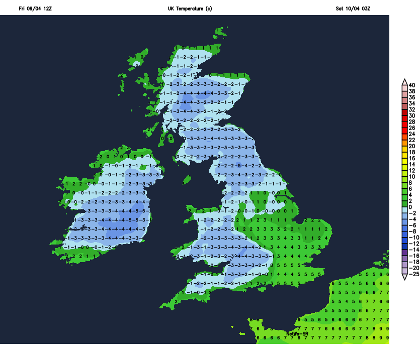
Temperatures forecast Friday night and Saturday morning

SATURDAY MORNING
Heavy showers will start to move into the northwest and north around dawn Saturday morning with falls of hail, sleet and snow for some places with some accumulations possible so don't be surprised if you wake up to a dusting of snow in parts of Ulster, there also will be the risk of thunderstorms on Saturday morning and afternoon.
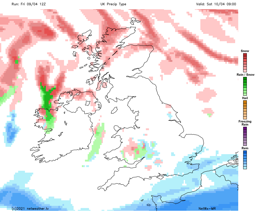
risk of snow showers in the west, northwest and north Saturday morning

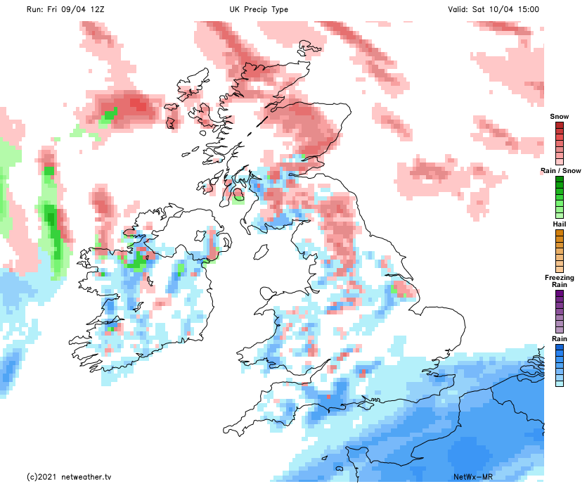
SATURDAY AFTERNOON AND EVENING
Showers will move southwards later in the morning and become widespread and heavy with isolated thunderstorms continuing again there will be the risk of hail, sleet and snow with the highest risk of snow accumulating been over the morning hours but some temporary accumulations of hail could also occur over the day in any part of the country leading to hazardous driving conditions so be prepared for sudden changes in road conditions if using the road network on Saturday . Between the showers there will be good sunny spells. Temperatures will range between 4C to 9C.
SATURDAY NIGHT / SUNDAY MORNING
Overnight Saturday into Sunday morning another sharp to severe frost will develop with lows of -5C to 0C. The Night will be clear and dry for much of the country but a few showers of sleet and snow may effect northwestern and northern coastal counties overnight Saturday into Sunday morning.
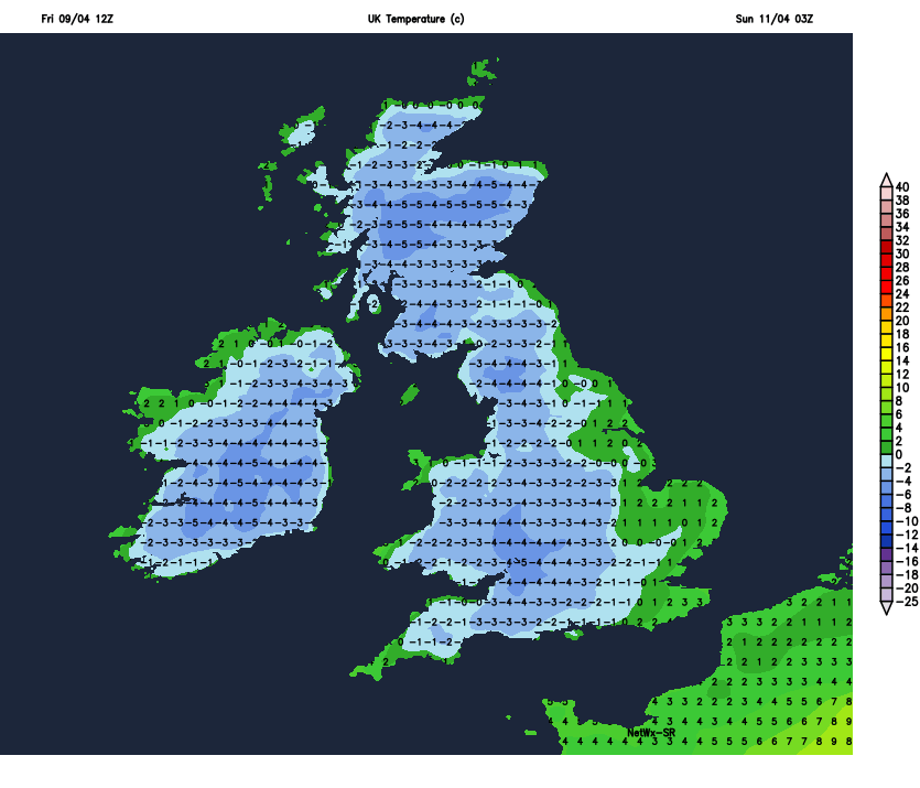
Temperature forecast Saturday night and Sunday morning

Some sleet and snow showers possible in the northwest Saturday night and Sunday morning
SUNDAY MORNING/ AFTERNOON
Sunday starting of dry and very cold with frost and ice. The morning will see good bright and sunny spells but later in the afternoon cloud will start to increase from the northwest with light rain and drizzle following from the northwest during the evening and night spreading to western and northern areas. Southern and Eastern areas will remain dry with a mix of cloud and clear spells.

Light rain and drizzle across western, northwestern and northern counites on Sunday night into Monday morning
Monday looks set to be a showery day everywhere but Tuesday will be a little drier with showers more isolated. It look set to become milder over the later stages of next week with a less risk of frost after Monday. The latest outlook for later next week is for good dry weather at times but some showers also with the best chance of any drier weather been across the northern half of Ireland later in the week. Some of the showers later in the week may be thundery in nature.
Kenneth from the Donegal Weather Channel
You can find all the latest weather warnings and forecasts by downloading our app from the google play store by clicking below

LATEST NEWS


