
RED WARNING STORM JORGE - Very severe winds , Heavy Rain, Snow and Flooding


Storm Jorge (named by AEMET, the Spanish meteorological service) is the latest in a series of Atlantic storms this month and is due to affect Ireland from early Saturday lasting into Sunday.
Storm Jorge is currently out of the west of Ireland this afternoon and will undergo rapid cyclogenesis
Cyclogenesis is the development or strengthening of cyclonic circulation in the atmosphere (a low-pressure area). Cyclogenesis is an umbrella term for at least three different processes, all of which result in the development of some sort of cyclone, and at any size from the microscale to the synoptic scale.
The process in which an extratropical cyclone undergoes a rapid drop in atmospheric pressure (24 millibars or more) in a 24-hour period is referred to as explosive cyclogenesis and in which this case Storm Jorge will undergo explosive cyclogenesis.


Storm Jorge (pronounced Hor-hay) is a storm centre which will undergo rapid cyclogenesis in the mid-Atlantic during Friday 28th February as it tracks northeastwards towards Ireland. It is then expected to fill slowly as it crosses over the north of the country during Saturday 29th February. The center of storm Jorge is then expected to pass close to the northwest and north of Ireland on Saturday afternoon, evening and night bring very severe and damaging winds with a Red wind warning issued for Clare and Galway with a nationwide orange warning.

Storm Jorge is forecast to bring very severe and damaging winds to western and northwestern coastal counties
(red wind warning) has been issued for Galway and Clare with gusts of 130 to 145km/h, with an elevated risk of coastal flooding,this warning will be in place for 3 hour between 1pm to 4pm Saturday
(orange wind warning) for Donegal, Sligo, Leitrim, Mayo, Galway, Clare and Kerry with gusts of 110 to 130km/h, possibly higher in very exposed areas with an elevated risk of coastal flooding. and less severe winds to the rest of the country. Valid: 06:00 Saturday 29/02/2020 to 03:00 Sunday 01/03/2020 and for Donegal, Sligo, Leitrim Valid: 12:00 Saturday 29/02/2020 to 03:00 Sunday 01/03/2020
(orange wind warning) Wind warning for Leinster, Cavan, Monaghan, Roscommon, Cork, Limerick, Tipperary and Waterford with gusts of 110 to 120km/h, possibly higher in very exposed areas. Valid: 13:00 Saturday 29/02/2020 to 19:00 Saturday 29/02/2020
A status red marine warning has been issued for all coastal waters for Saturday and this means any Islands of the west of Ireland or northwest is under a red wind warning. Southwest gale force 8 to strong gale force 9 will develop tonight on Irish Coastal Waters from Mizen Head to Slyne Head to Rossan Point. Winds will veer westerly Saturday morning and increase to Storm Force 10 and occasionally Violent Storm Force 11.
Spells of heavy rain associated with Storm Jorge will worsen the flooding situation across the country. A yellow level rainfall warning is currently in operation for Munster, Connacht and Donegal until place until Saturday night.
Continues below
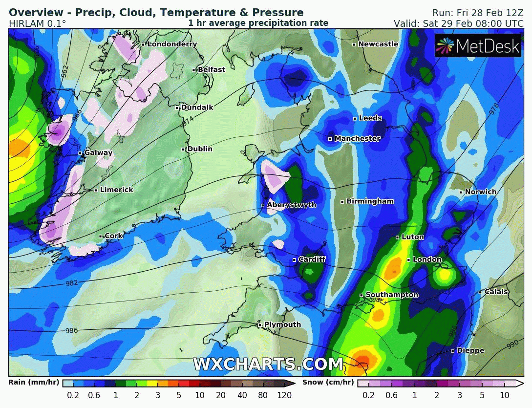
On Saturday morning a band of heavy rain associated with storm Jorge will move in from the west of the Atlantic and the current model data show that temperatures will be close to or at freezing level for many areas to start on Saturday morning with the risk of icy patches around dawn Saturday morning.
With Temperatures close to 0C in some places on Saturday morning even as low as -1C as this band of rain moves in of the Atlantic just after dawn Saturday morning there are indications that this will fall as heavy sleet and snow for a time across many parts of Ireland with very poor conditions and some accumulations of snow in places. The animation below shows this outcome taken from the HIRLAM high resolution model. Other models like the GFS, ECMWF and ICON show a similar outlook. This possible snow and sleet will then turn back to rain again later in the morning. Some places could see a hour or 2 of heavy snowfall followed by heavy rain again so any snow on the ground would soon melt.
Continues below
Flooding issues
A) Elevated river levels
Currently river levels are elevated across the country, particularly in the Midlands (Shannon catchment). Levels across the Northern half of the country are also high. Therefore, additional rainfall over the coming days will compound the flooding issues here.B) Coastal Flooding
We are in a period of transition between Spring (High) Tides and Neap (Low) Tides. This means there will not be a large variation between high and low tides. The combination of high seas and strong winds or stormy conditions associated with Storm Jorge may increase the possibility of coastal flooding, especially in flood-prone areas along the Atlantic coast on Saturday (particularly when coincident with high tides).


Click on the tabs below to view the new forecasts available under the forecast section.
2019 CALENDAR NOW ON SALE


2019 Calendar now on sale
You can now purchase the Donegal Weather Channel Calendar 2019. You can purchase the Calendar from the online store
All calendars will be posted out in the middle of November with only a limited amount available. Calendars can be purchased anywhere across the world.


The stunning Leitir Mhic An Bhaird (Lettermacaward) Donegal during May 2018

Vivid Rainbow from up on Breezy mountain South Donegal

I was in Albufeira Portugal I was waiting for the full moon to come up and it did not let me down.
The orange and red tints that the Moon sometimes take on rising and setting are caused by the particles in the Earth's atmosphere. When light (or more specifically, packets of light called photons) from an astronomical object passes through the Earth's atmosphere, it scatters off of particles in the latter.

What a unbelievable night and morning out storm chasing, These number of thunderstorms had to be the best in years as most of the lightning was CG bolts. I even manage to captures Two to three CG bolts in one shot.

One of the most beautiful views of Slieve league From sea and got some nice photos.
Photos from this angle I have not seen yet and it was wonderful to finally capture that moment.