
Risk of a severe wind storm Sunday night into Monday with severe and damaging gusts


A area of low pressure is set to develop of the eastern coast of the USA today and track across the Atlantic over the course of Friday, Saturday and Sunday. As the area of low pressure tracks across the Atlantic of the west coastal of Ireland on Sunday evening and night the area of low pressure starts to deeping rather quickly with the central pressure dropping fast.
Continues below


On Sunday evening the area of low pressure will be located of the west of Ireland and from Sunday evening into Sunday night the area of low pressure starts to rapidly develop undergoing rapid cyclogenesis as it tracks of the northwest and north of Ireland with a sharp and strong windfield forming as them isobars real tighten up.

The area of low pressure of the west coast of Ireland on Sunday evening and night

The area of low pressure of the northwest coast of Ireland on Monday morning around dawn with it undergoing rapid cyclogenesis
Continues below
On Monday morning around dawn the area of low pressure will be located of the northwest coasts of Ireland moving northeast wards but then near the northwest coast of Ireland it starts to move in a more westerly track after dawn and later Monday morning with the main core of them strong winds getting into northwestern and northern counties with gusts between 100km/hr to 130km/hr possible especially at this stage across Mayo, Sligo, Leitrim, Donegal, Derry Tyrone, Antrim and Down as it tracks of the north of Ireland in a westerly direction across Scotland on Monday afternoon and evening when them strong winds look set to effect northwestern and northern counties. Elsewhere across Ireland winds will gust between 50km/hr to 90km/hr with the least strongest winds across the southern half of Ireland.
Continues below
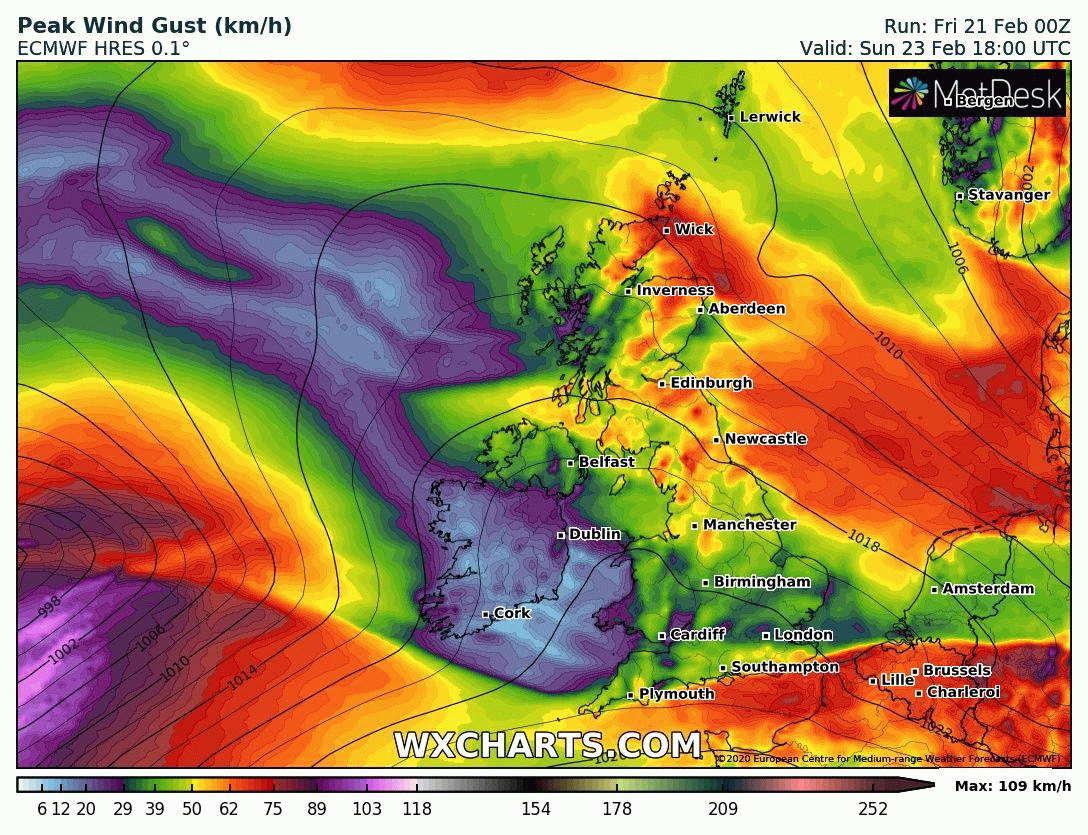
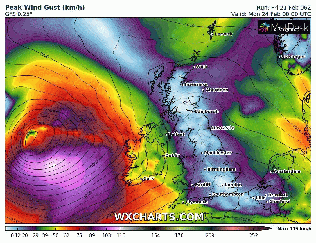
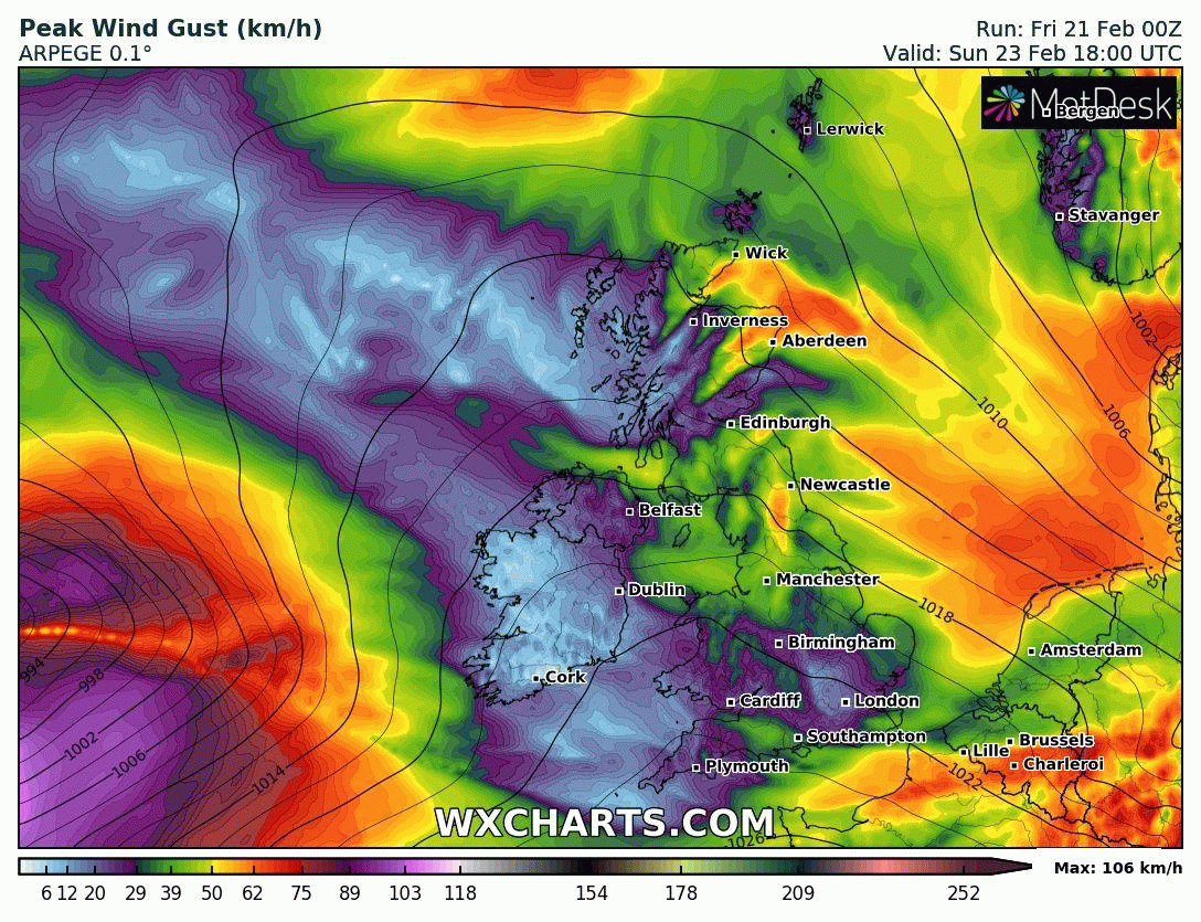
Below you will find the latest model runs attached showing a similar track and outcome on Sunday night and Monday
ECMWF MODEL - STORM TRACK
Area of low pressure of the west of Ireland midnight Sunday
GFS MODEL- STORM TRACK
ICON MODEL - STORM TRACK

Area of low pressure over the north of Scotland Monday evening and night with strong and severe damaging gusts
ARPEGE - STORM TRACK
Continues below
Today’s forecasting model runs all have the area of low pressure and main core of winds tracking further to the south over northwestern and northern counties which at this stage seem to be all on the same level.
This could trigger Met Eireann or the UK Met office naming the storm over the coming 24 hours along with warnings and advisories been issued. By this evening and Saturday morning the track of this are of low pressure will be better known and any more shifts to the south as it takes that westerly track of the north of Ireland and over Scotland would not be great and could give some extreme conditions across the northwest and north of Ireland.
Explosive cyclogenesis
Explosive cyclogenesis (also referred to as a weather bomb, meteorological bomb, explosive development,bomb cyclone or bombogenesis) is the rapid deepening of an extratropical cyclonic low-pressure area. The change in pressure needed to classify something as explosive cyclogenesis is latitude dependent. For example, at 60° latitude, explosive cyclogenesis occurs if the central pressure decreases by 24 mbar (hPa) or more in 24 hours.This is a predominantly maritime, winter event, but also occurs in continental settings, even in the summer.This process is the extratropical equivalent of the tropical rapid deepening. Although their cyclogenesis is totally different from that of tropical cyclones, bomb cyclones can produce winds of 74–95 mph, the same order as the first categories of the Saffir-Simpson scale and give heavy precipitation. Even though only a minority of the bombs become so strong, some have caused significant damage.
I will have another update this evening if there are any further changes or shifts to the system so stay tuned.
Kenneth from the Donegal Weather Channel


Click on the tabs below to view the new forecasts available under the forecast section.
2019 CALENDAR NOW ON SALE


2019 Calendar now on sale
You can now purchase the Donegal Weather Channel Calendar 2019. You can purchase the Calendar from the online store
All calendars will be posted out in the middle of November with only a limited amount available. Calendars can be purchased anywhere across the world.


The stunning Leitir Mhic An Bhaird (Lettermacaward) Donegal during May 2018

Vivid Rainbow from up on Breezy mountain South Donegal

I was in Albufeira Portugal I was waiting for the full moon to come up and it did not let me down.
The orange and red tints that the Moon sometimes take on rising and setting are caused by the particles in the Earth's atmosphere. When light (or more specifically, packets of light called photons) from an astronomical object passes through the Earth's atmosphere, it scatters off of particles in the latter.

What a unbelievable night and morning out storm chasing, These number of thunderstorms had to be the best in years as most of the lightning was CG bolts. I even manage to captures Two to three CG bolts in one shot.

One of the most beautiful views of Slieve league From sea and got some nice photos.
Photos from this angle I have not seen yet and it was wonderful to finally capture that moment.