
Powerful area of high pressure across Europe keeping the weather dry up until the new year


Powerful blocking high pressure sitting over Europe
The forecast across much of Europe heading into the new year looks dry including here at home in Ireland as a strong ridge of high pressure sits over much of Western and northern Europe.
This area of high pressure also known as a blocking high is the main reason for milder temperatures than normal across west Europe this weekend
continues below


What is a blocking high pressure system?
Meteorologists refer to a 'blocking' high when a large area of high pressure becomes stationary, resulting in the blocking or redirection of low pressure systems.
A blocking high in this case results in very slow progression of weather fronts across the Ireland, as the high pressure blocks their movement.
So your normal wet and windy weather coming in from the west or the Atlantic is diverted away with much more settled weather.
Below as you can see on the radar across much of Europe there is a lot of dry weather as the blocking high sits in places.
continues below


Western Europe including Ireland and the UK is one of the warmest places in Europe this weekend with temperatures between 10C to 14C this warmer airmass can be seen on the 850 hPa temperature Anomaly chart below.
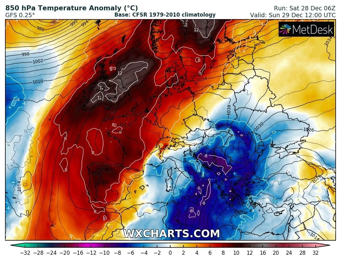
850 hPa temperature Anomaly
At present the forecast over the first week of 2020 shows no real adverse weather conditions. Some models even hint that high pressure could build again after a brief unsettled spell of weather but time will tell.


Click on the tabs below to view the new forecasts available under the forecast section.
2019 CALENDAR NOW ON SALE


2019 Calendar now on sale
You can now purchase the Donegal Weather Channel Calendar 2019. You can purchase the Calendar from the online store
All calendars will be posted out in the middle of November with only a limited amount available. Calendars can be purchased anywhere across the world.


The stunning Leitir Mhic An Bhaird (Lettermacaward) Donegal during May 2018

Vivid Rainbow from up on Breezy mountain South Donegal

I was in Albufeira Portugal I was waiting for the full moon to come up and it did not let me down.
The orange and red tints that the Moon sometimes take on rising and setting are caused by the particles in the Earth's atmosphere. When light (or more specifically, packets of light called photons) from an astronomical object passes through the Earth's atmosphere, it scatters off of particles in the latter.

What a unbelievable night and morning out storm chasing, These number of thunderstorms had to be the best in years as most of the lightning was CG bolts. I even manage to captures Two to three CG bolts in one shot.

One of the most beautiful views of Slieve league From sea and got some nice photos.
Photos from this angle I have not seen yet and it was wonderful to finally capture that moment.