
Latest update on the risk of snow for parts of Ireland on Thursday, Friday & Saturday

All ready some parts of the country has seen snowfall with snowfall also over northern parts of Donegal overnight and this morning from a train of sea steamer showers move east to west across the areas giving a few centimeters there.
At the end of this week an Atlantic frontal system will move in from the Atlantic and move northwards across the country but there is a high degree of uncertainty at the moment on how much snow will fall in places


As mentioned on Monday it is complex set up due to a Scandinavian high pressure system to the northeast of Ireland which could fight back and decay the frontal system as in moves northwards across Ireland
The ECMWF weather model shows the frontal system will move up across the southwest of Ireland Ireland on Thursday morning just before dawn and move northeastwards in direction but it will be rather slow which is not good news if you live across the north of Ireland and are looking for a fall of snow. The ECMWF model shows the frontal system only reaching south Connacht and south Leinster around midday.
It only shows the frontal system reaching other parts of Connacht and Leinster overnight before fizzling out and the High pressure to the northeast winning the battle and keeping much of Ulster and north Leinster dry.
Some areas across Munster and Connacht could see moderate to light snowfall over a period of around 9 hours with some areas receiving up to 10cm but other areas of around 5cm or under.
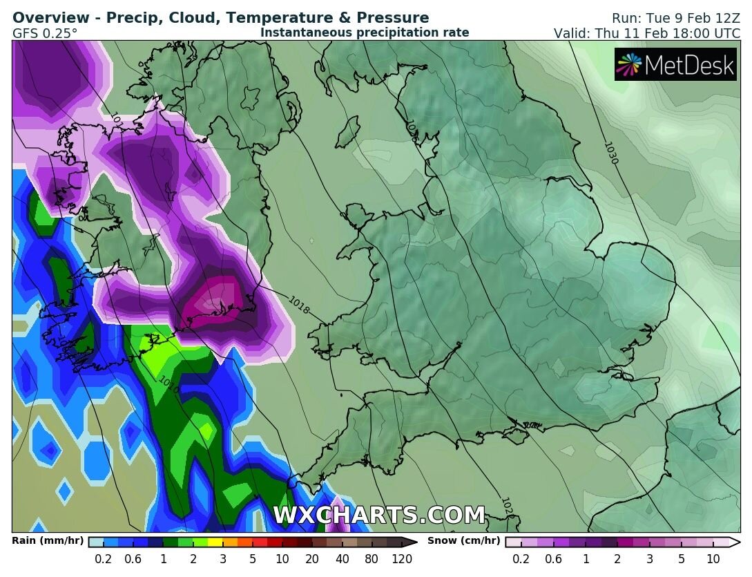
The charts below shows where the front stalls on Thursday night


The GFS model is sticking to its guns and showing the frontal system moving up across Ireland a little more quickly on Thursday with northern parts of Ireland also at risk of snowfall and this is why I say there is uncertainty.
The GFS has the front moving into the southwest on Thursday morning at around dawn and moving northeast extending over Connacht and south Leinster by the evening and west and south Ulster on Thursday night.
The GFS shows the snow turning back to rain later in the afternoon across the south Munster and west Munster. If the GFS outcome was to occur north Connacht, south Ulster and north Leinster would see the front stall giving 6hours to 12 hours of snow for some places later Thursday into Friday morning and with moderate to light falls at times. Accumulations of 10cm across north Connacht , south Ulster and north Leinster could occur.
Charts below show this outcome.


The warning issued by Met Eireann this morning covers all of Connacht, Leinster and Munster for Thursday under a status yellow snow/ice warning with Ulster not under any warning and this is what Met Eireann are basing there warning on the ECMWF model outlook but will most likely issue a updated warning on Wednesday when there own Harmonie model will be in a better range to pick up the frontals system on Thursday. When the early warning was issued this morning there model would not of been in this time range as it only runs to 54hours ahead.
It really could go anyway yet with changes possible even at this time period and sometimes these frontal systems can give a few surprises.
I think come tomorrow we will have a much better idea.
RISK OF FURTHER SNOW LATER FRIDAY
The GFS, ICON, ECMWF, GEM models then show another fall of snow on Friday night and Saturday morning for east Connacht, Ulster and north Leinster as another frontal system moves in from the west and hits the colder air hanging on over these areas.
At the moment due to Thursdays snowfall event it will be hard to tell until later Wednesday night or Thursday what the possible outcome will be from that risk overnight Friday into Saturday morning with some of the models projecting some large accumulations of to 5cm for some areas and 10cm to 30cm in others with the biggest amounts across higher ground areas.


Kenneth from the Donegal Weather Channel
You can find all the latest weather warnings and forecasts by downloading our app from the google play store by clicking below

LATEST NEWS


