
Ireland looks set to be hit with another strong windstorm this Saturday


At this stage with many areas of Ireland under water due to heavy rainfall over the month of February the question people are asking is there any improvements looking possible in the weather over the coming days or week and to put it simply to people the answer is no.
With already 2 storms this month Storm Ciara and Storm Dennis it now look like another storm will hit Ireland this weekend but really that’s nothing new at this stage as many of the storms seem to time it well when it comes to hitting the country on weekend days just like storm Ciara and Dennis did.
Continues below


In the last week we have seen all sorts of kind of conditions from strong winds, heavy rainfall, flooding, hail, sleet, snow, thunder & lightning but the only thing that we are missing is a little extra sun and warmer weather.
Back at the end of January in the Donegal Weather Channel outlook we did say that this month was looking very unsettled with stormy periods with some colder periods mixed in between and the main risk of snow coming from areas of low pressure or rain bumping into colder air just like we seen on Sunday night and Monday morning when the northwest and north woke up to large accumulations of snow with some areas seen between 10cm to 15cm.
Looking ahead as we head into the start of meteorological spring in Ireland the weather looks like it will stay on the cooler side with heavy pulses of rain moving in from the Atlantic. There will also be the risk of some wintry episode with some sleet and snow mainly across the northern half of Ireland.
Over the Month of March I would not expect to see as many as storms as we have seen in February.
Latest data also suggests some sort of pattern change around the middle of March with drier witg high pressure building but the weather still on the cooler side with easterly winds.
Continues below
Before we look at the weekend storm risk we will look at Friday as more heavy rainfall is expected. On early Friday morning a band of rain will spread in from the southwest of Ireland extending to all areas later Friday morning and as this spreads northeastwards there is a potential that it could turn to sleet and snow across the northwest of Ireland over the counties of Donegal, Derry, Tyrone, Fermanagh, Leitrim and Sligo. The most likely outcome will be rain and sleet to lower levels with sleet and snow over higher ground areas.

Some sleet and snow possible on Friday morning across the northwest of Ireland.
The rain will then clear through over Friday afternoon with showers following behind. Friday night another band of rain will spread into the southwest extending to all areas overnight and early Saturday morning with the risk of spot and localised flooding. Around 15mm to 35mm is expected with the highest amounts in the south of Ireland, A rainfall warning looks like it will be issued for southern coastal counties of Munster for Friday especially across Kerry, Cork and Waterford.
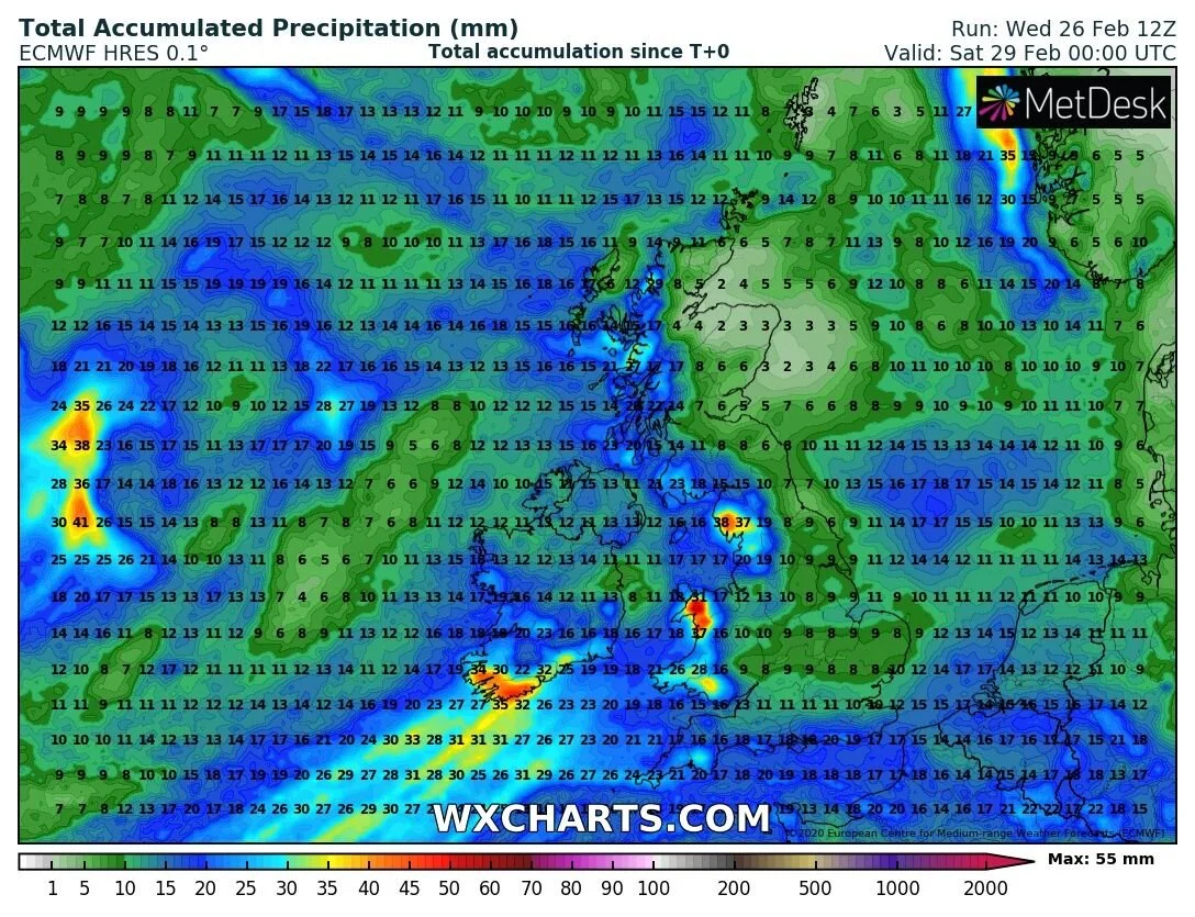
Rainfall accumulations in mm for Friday with heavy rain for many areas biggest amounts across the southern half of Ireland.
Continues below
A area of low pressure which at this stage looks as it will be named Storm Ellen in the next 24 hours by Met Eireann will then move close to the west and northwest of Ireland later Saturday morning and looks set to bring very strong winds on Saturday. This can be seen on the chart below

At present it looks very windy nationwide on Saturday with winds gusting between 90km/hr to 110km/hr.
Along southern, southwestern and western coastal counties winds look strong during the hours of later Saturday morning and afternoon with severe gusts between 100km/hr to 125km/hr with some isolated gusts of 130km/hr possible on exposed coastal areas of the west.
During the evening and night as the area of low pressure tracks of the north of Ireland and exits over scotland them strong and severe gusts will then transfer across coastal counties of the west, northwest and north with gusts between 100km/hr to 125km/hr possible.

There is a little uncertainty regarding the track yet but that should become more clear on Thursday or early Friday.
Continues below
Along with the risk of strong or severe winds there will also be the risk of poor conditions around all irish coasts especially along the western seaboard where some coastal flooding could be possible.
On Saturday there will also be the risk of very heavy falls of rain or heavy showers merging into longer spells of rain which is not good news with all the flooding across Ireland already and this is only going to increase the chances of further flooding and river levels rising . Some areas on Saturday could see well between 15mm to 40mm of rain accumulate over the day especially across the west, midlands, northwest and north of Ireland.
Some of the showers on Saturday could also fall as hail, sleet or snow but any snow will be over higher ground.
I will have another update on Thursday when the weather models should have a clearer picture on the possible track.
Kenneth from the Donegal Weather Channel


Click on the tabs below to view the new forecasts available under the forecast section.
2019 CALENDAR NOW ON SALE


2019 Calendar now on sale
You can now purchase the Donegal Weather Channel Calendar 2019. You can purchase the Calendar from the online store
All calendars will be posted out in the middle of November with only a limited amount available. Calendars can be purchased anywhere across the world.


The stunning Leitir Mhic An Bhaird (Lettermacaward) Donegal during May 2018

Vivid Rainbow from up on Breezy mountain South Donegal

I was in Albufeira Portugal I was waiting for the full moon to come up and it did not let me down.
The orange and red tints that the Moon sometimes take on rising and setting are caused by the particles in the Earth's atmosphere. When light (or more specifically, packets of light called photons) from an astronomical object passes through the Earth's atmosphere, it scatters off of particles in the latter.

What a unbelievable night and morning out storm chasing, These number of thunderstorms had to be the best in years as most of the lightning was CG bolts. I even manage to captures Two to three CG bolts in one shot.

One of the most beautiful views of Slieve league From sea and got some nice photos.
Photos from this angle I have not seen yet and it was wonderful to finally capture that moment.