
Further heavy falls of snow overnight for the north and northwest of Ireland with hazardous driving conditions

Snowfall in Ardbatt (Close to Breenagh), off the Letterkenny to Glenties Road, Donegal this afternoon Image by @PatrickA7071
Much colder air will be in places across Ireland over the course of this evening and this weekend which will increase the risk of snowfall.
The northwest and north of Ireland will see further heavy falls of snow overnight with heavy showers moving in from the northwest falling as hail, sleet and snow in places.

Heavy falls of rain, hail and sleet will turn increasingly to snow again overnight and on Saturday morning giving accumulations across the north and northwest of between 1cm to 5cm. Showers at times will merging into long spells of snow for places.
The biggest amounts of snow overnight and on Saturday morning are expected across west Ulster and north Connacht, Donegal, Sligo, Leitrim, North Mayo, North Roscommon, Tyrone, Derry and Fermanagh

The animation below shows showers continuing over the rest of today, tonight and on Saturday morning with roads conditions becoming even more hazardous from these evening as showers turn increasingly to snow and temperatures drop further across the rest of the northwest of Ireland with falls of snow expected across Mayo, Sligo, Leitrim , Roscommon as well as Donegal and the rest of Northern Ireland leading to accumulations before sunrise Saturday morning
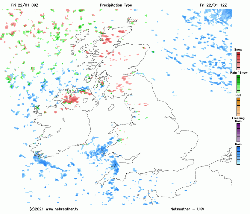
Snow showers effecting the northwest and north overnight and on Saturday morning with some accumulations by morning
The below animations shows snow accumulations across the northwest region by Saturday morning and more widespread accumulations by Sunday morning across the whole of Ireland,


It will also turn very cold overnight across the whole country with lows of -4C to -1C with a sharp to severe frost developing with very icy conditions. Across the North and Northwest where snowfalls and settles on the ground and becomes compact this will allow for very dangerous and hazardous driving conditions.
The animation below shows temperatures overnight and on Saturday morning across Ireland between 5pm Friday until 1pm Saturday

TWO WEATHER WARNINGS ISSUED FOR SNOW AND ICE
FRIDAY NIGHT & SATURDAY MORNING

STATUS YELLOW - SNOW/ICE WARNING FOR DONEGAL, DERRY, TYRONE, FERMANAGH, ANTRIM, ARMAGH, CAVAN, MONAGHAN, SLIGO, LEITRIM, ROSCOMMON & MAYO
Donegal Weather Channel Weather Warning
Heavy showers will effect much of Ulster and north Connacht from this afternoon right through until Saturday morning with showers turning increasingly to snow in places this evening and overnight giving accumulations of 1cm to 4cm on some low level areas. With up to 10cm accumulating across higher ground areas.
Treacherous and hazardous driving conditions will occur with icy conditions. Extra caution is advised on all routes overnight
Valid: 12:00 Friday 22/01/2021 to 12:00 Saturday 23/01/2021
Issued: 10:00 Friday 21/01/2021
SATURDAY MORNING & SUNDAY MORNING

STATUS YELLOW - SNOW/ICE WARNING FOR IRELAND
Met Éireann Weather Warning
Falls of sleet and snow on Saturday evening and night will give some snow accumulations across Northern Ireland leading to Icy and hazardous conditions. between 1cm to 5cm will accumulated across some lower level areas with up to 10cm across higher ground areas
Valid: 18:00 Saturday 23/01/2021 to 12:00 Sunday 24/01/2021
Issued: 12:00 Friday 22/01/2021
STATUS YELLOW - SNOW/ICE WARNING FOR DERRY, TYRONE, FERMANAGH, ANTRIM, DOWN & ARMAGH
Donegal Weather Channel Weather Warning
Falls of sleet and snow. Icy and hazardous conditions.
Valid: 10:00 Saturday 23/01/2021 to 12:00 Sunday 24/01/2021
Issued: 12:00 Friday 22/01/2021
VIDEO OF MOUNTAIN TOP, LETTEKENNY AT A STAND STILL DUE TO SNOW
Kenneth from the Donegal Weather Channel
You can find all the latest weather warnings and forecasts by downloading our app from the google play store by clicking below

LATEST NEWS


