
UPDATE - Turning much colder this weekend with the risk of snow over much of next week

This weekend will see the weather turn colder and very cold later Sunday into next week with very cold temperatures expected with some area dipping to -6C and possibly lower at times leading to severe frosts at night. There will also be the risk of snowfall for places during the week with a more widespread snowfall event later in the week across Ireland. Next weekends cold spell is now locked in.
The Met Office UK and Met Eireann have issued updates and are in agreement that Ireland will see a much colder period next week with the risk of snowfalls in places.

The source of the colder air this weekend and next week will come out of Scandinavia rather than Siberia which is where the very cold air came from at the end of February 2018 which is why that period of weather was dubbed the beast from the east.
Will next weeks very cold weather be a beast from the east?
To answer that quest no it will not be a beast from the east as the cold air source isn’t coming direct out of Siberia. Next week will see upper air temperatures across Ireland of -10C not as cold as the beast from the east in 2018 when colder upper air temperatures arrived over Ireland with lows of -14C to -15C around 1500 meters above the ground.
Will it be the coldest weather since 2010
No it wont be the coldest weather since 2010 as some pages and people are statin. It will be the coldest period of weather this winter and the coldest since the end of February 2018


ECMWF UPPER AIR TEMPERATURES AT 850hPa BETWEEN SATURDAY THE 6TH and SATURDAY THE 13TH OF FEBRUARY 2021
The above animation is from this evening 12z ECMWF model run showing them colder upper air temperatures moving in from the east from Saturday with that very cold air arriving on Sunday and remaining with us until later next week well at least until later Thursday across the northern half of Ireland
There still is some uncertainty on how long this colder spell will stick around but this evenings model runs show it been a 4 to 5 day very cold snap rather than a prolonged cold spell but at the moment this is uncertain and it may last into the weekend for some northern parts of Ireland.


SNOWFALL RISK
MONDAY TO WEDNESDAY
Leinster, east and north Ulster will be most at risk of snow showers coming in the form of sea streamers also known as lake effect snow which will form into organized bands of snow at times with the potential for some thunderstorm activity also. Highest accumulations are likely to occur across the eastern half of Leinster into east Ulster. Some snow showers that become organized will also work there way further inland due to the strong easterly wind behind them with some parts of east Connacht and mid Munster possibly seen a dusting but not all areas at risk.
Some of these showers from Monday to Wednesday could see accumulations build up and accumulating in excess of 10cm. The fine details are yet uncertain but come Saturday evening into Sunday much more detail will be known and places that will be at a higher risk in the advisory area will become more clear.
The problem with the weather forecasting models is the fail to pick up these sea streamers at this range until around 48 hours out and sometimes it can be a nowcast with the forecasting models failing to show these at all and this is where a human input is important in the forecast. You will also notice some of your weather apps show very little snow now but come next week a few hours before they could show none stop snow for parts.
The below image from the ECMWF show these in some way due to it been a very good model and runs at a higher resolution than most but even at that it is most likely under playing the strength of these convective showers. Monday evening and Tuesday there will be prime conditions for these streamers especially across Leinster and as I mentioned above with the strength of the east wind some inland areas as far as mid Munster, east Connacht and and possibly central parts of Ulster also seen some snow showers.

WEDNESDAY AFTERNOON AND LATER NEXT WEEK
The latest model outputs this evening shows an Atlantic low pressure system then moving near the southern half of Ireland on Wednesday evening with a band of precipitation moving up from the south overnight falling as snow as it hits that very cold air across Ireland and as it moves northwards overnight and on Thursday morning giving giving widespread snowfall across the whole country with significant accumulations.
Charts from the ECMWF this evening show this below
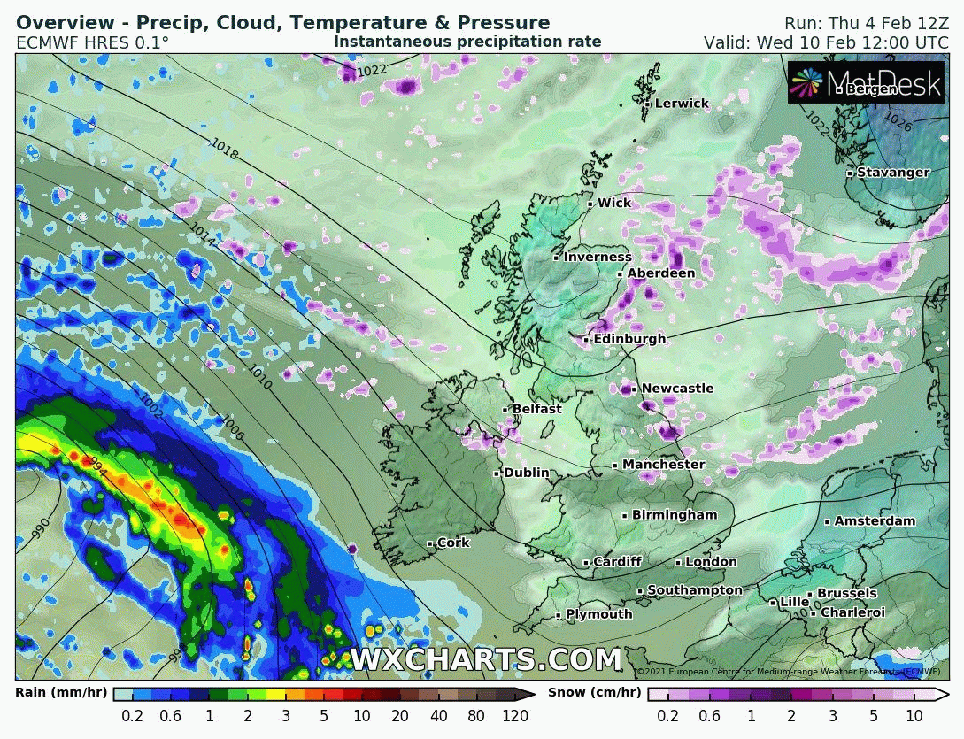
Snowfall accumulations by Wednesday morning 10/02/212
SURFACE LEVEL TEMPERATURES
Temperatures next week by day will range between -1C to 3C with some areas not rising above freezing and frost and icy conditions persisting in places by especially across areas that see snowfall.
Night time lows could fall down to -3C to -C with the coldest temperatures across the western half of Ireland. Severe frosts and icy conditions nationwide

Very cold next week
SEVERE WINDCHILL FACTOR - STRONG EASTERLY WINDS
A severe Windchill is also expected next week espically on Monday and Tuesday with a Windchill factor possibly as low as -9C to -12C by night and day.

Northeasterly to easterly winds will be Moderate to strong at times also over the week

LIVE STOCK DANGERS - FARMERS
I would also like to add one final thing for famers with livestock especially over higher ground areas to be alert and keep a eye on the forecast due to the significant risk of big snowfall accumulations next week over eastern and northern counites. Low temperatures and a added wind chill factor will create very harsh conditions putting animals in danger exposed to such conditions.
Donegal weather channel has issued early advisories ahead to next weeks very cold spell of weather. Click advisory maps below to view them


Kenneth from the Donegal Weather Channel
You can find all the latest weather warnings and forecasts by downloading our app from the google play store by clicking below

LATEST NEWS


