
Turning wet and windy at the end of the week but turning warmer on Sunday
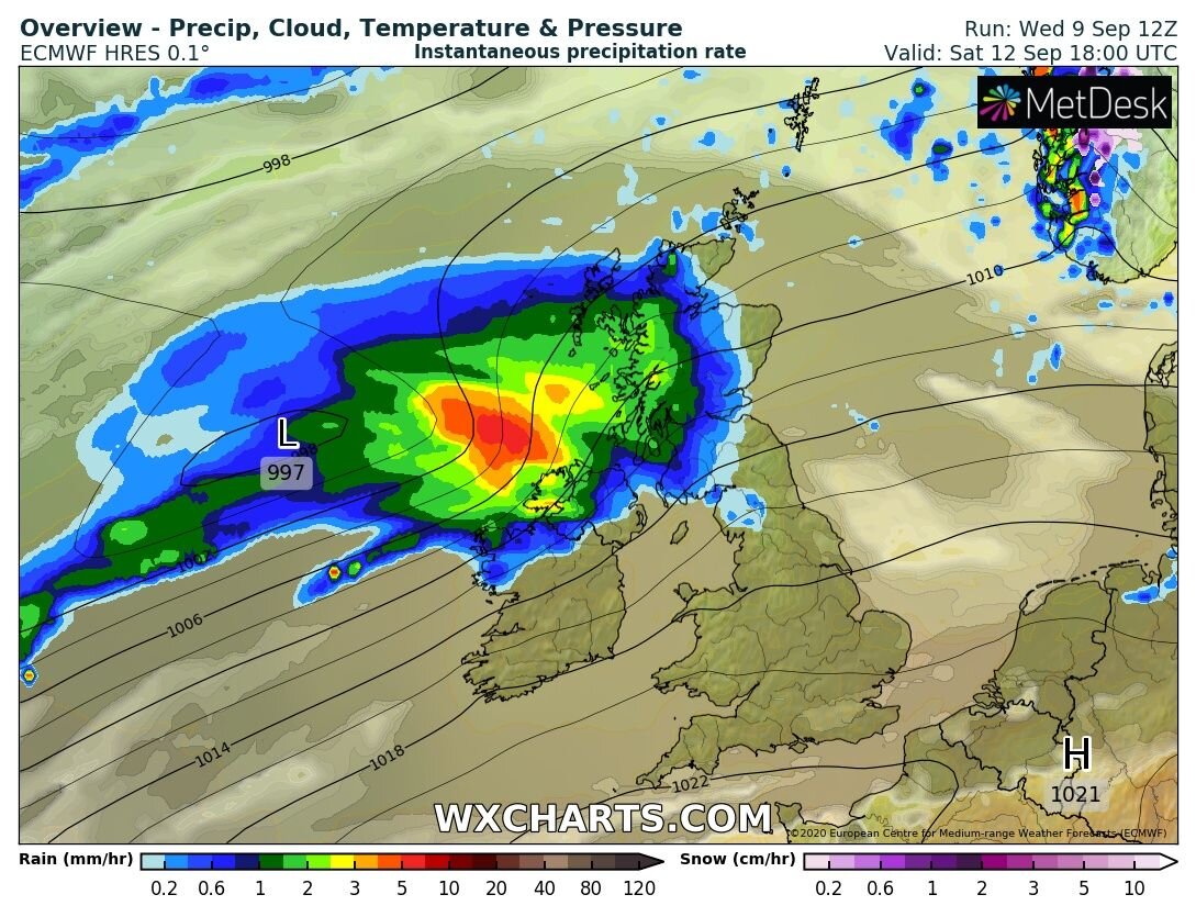
The end of this week and the start of this weekend will see some heavy rainfall in places and it will turn very windy especially on Thursday night and Friday and again on Saturday into Sunday morning. The driest weather will be across the south and east of Ireland but heavy rainfall will effect the west and north particularly the northwest Donegal, Derry, Sligo, Leitrim Fermanagh & Mayo on Friday morning and again Saturday afternoon, evening and for a time overnight.
Rainfall amounts between Friday morning until midnight Saturday across the northwest will range between 15mm to 20mm but higher amounts look possible across Donegal with up to 50mm possible across the counties especially over higher parts. There will be the risk of some flooding especially across Donegal.

The rest of the west and north will only see rainfall amounts of between 5mm to 10mm with up to 15mm across parts of (north & west Connacht) & (mid and west Ulster) elsewhere amounts of only 1mm to 2mm will be possible with some parts of the south and southeast missing out on any precipitation at all
Some warnings will be possible for Rainfall mainly across Donegal on Saturday and for wind across some western and northern areas on Saturday also.
The good news is that the forecast looks better for Sunday and it will be warm and humid with temperatures in the low 20s for some places.


For the latest forecast in detail read below
THURSDAY 10TH SEPTEMBER 2020
A mainly dry to start the morning with some bright or sunny spells. Later in the morning and over the afternoon cloud will increase from the west with the risk of some drizzle in parts of Atlantic coastal counties. Temperatures will range between 14C to 17C.
Overnight will start of dry but winds will increase overnight especially across the west, northwest and north with strong southwesterly winds. Rain will push into the northwest after midnight with heavy falls across the west, northwest and north but as rain moves southeastwards it will become less heavy
FRIDAY 11TH SEPTEMBER 2020
Friday morning will start of wet & windy with strong southwesterly winds. Rain will push into the northwest after early in the morning with heavy falls across the west, northwest and north but as rain moves southeastwards it will become less heavy. Rain will clear to the southeast on Friday morning with bright and sunny weather following from the northwest but some heavy shower also for a time before drier weather moves across Ireland over the evening. Temperatures will range between 14C to 17C. Winds will be strong and southwesterly at first but will become moderate later and westerly in position.
Mainly dry overnight for many with some clear spells but some showers effecting parts of the west and northwest overnight. Temperatures will range between 7C to 11C
SATURDAY 12TH SEPTEMBER 2020
Starting of dry on Saturday morning with some bright or sunny spells but cloud increasing later in the morning with rain effecting western, northwestern and northern counties over the afternoon and evening it will be drier but cloudy elsewhere. It will turn windy over the later afternoon and evening with strong southwest to westerly winds across the southwest, west and north. Temperatures will range between 14C to 17C.
Further rainfall overnight for parts the west, northwest and north with some heavy falls in places. Southwest to westerly winds will remain strong overnight across the west and north with gales along northwestern coastal areas. Temperatures will range between 10C to 14C.
SUNDAY 13TH SEPTEMBER 2020
Sunday will be warm and humid with bright and sunny spells over the day as a ridge of high pressure builds from the east allowing warm air to filter in with temperatures range between 18C to 24C.
MONDAY 14TH SEPTEMBER 2020
With warm and humid air sitting across Ireland high pressure will sit to the east and a area of low pressure to the south southwest this could allow heavy thundery rain to push northwards across Ireland leading to the risk of flooding in places. It will be warm and humid with sunny spells in places but that risk of heavy rain or shower will also linger in this kind of set up
OUTLOOK
Further heavy shower look possible on Tuesday but come the middle next week fresher weather looks set to move in from the Atlantic again.
* Only ANDROID users at moment.
* Features under development.
LATEST NEWS


