
TURNING WARMER NEXT WEEK WITH TEMPERATURES RISING TO AROUND 24C


Over the past month the weather overall has not been to bad with rainfall amounts rather small. Over the Easter weekend we were blessed with warm weather and sunshine with the highest temperatures of 2019 so far recorded. This was due to High pressure sitting over Ireland allowing a warm south east airflow bringing warmer conditions and drying the ground out enough with many gorse fires over and after the Bank holiday weekend with the most noticeable fires in west Donegal where members of the fire service in the county along with other emergency services and members of the public eventually getting the wild fires under control.
Following that glorious weekend of weather Ireland was then hit with a violent wind storm named Hannah with two different red warnings issued for Clare and Kerry where very strong winds hit the area and caused many power cuts and trees to come down across the south and southwest of Ireland. The rest of Ireland got of lucky with no major problems. The weather then stayed unsettled up to the end of the month.
The first weekend of May the weather again became much drier again with high pressure building across Ireland but the bank holiday weekend just gone was more noticeably colder due to a northerly airflow which brought much cooler conditions over the weekend and frost to some areas. On Sunday morning the 5th of May it started off very cold for the time of year with many areas recording temperatures below 0C with -2.5C recorded in Mullingar that morning.
CONTINUES BELOW

This week it was back to the rain after a dry start but the good news is that the rain is not going to do much harm and will only stick around for a few days
This weekend Saturday will see some bright and sunny spells across much of Ireland but over the afternoon for a time some light showers may develop over Ulster and push southwards over the early afternoon and evening but any showers will fizzle out by late evening and night. It will become drier and clear overnight with the risk of some frost again in areas. Temperatures over the day on Saturday will be slight improvement than temperatures this week highs of around 10C to 16C. Overnight will see some frost as it turns colder with temperatures ranging between 0C to 3C.
At present Sunday looks like it could be a mostly cloudy day for most with some hazy sunshine across the east. There is a risk of a little rain across the west and north over the afternoon as weather front tips Atlantic coastal areas of the west and northwest. Again overnight there will be the risk of frost and the reason we are seeing frost at night and cooler day time temperatures is due to that northerly airflow.
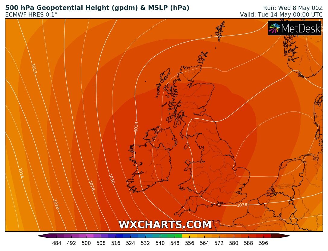
Early next week is looking much warmer with temperatures in the low 20s and just look at the area of high pressure (pictured above) and where it will be sitting right over Ireland the perfect place. This is the latest run from the ECMWF model. Current indications show temperatures over next week reaching as high as 24C maybe even 25C as the high pressure centres itself over Ireland with a warm south to southeast airflow.
In this set up the warmest temperatures will be across the west and northwest of Ireland but coolest across the east, southeast and south due to sea breezes keeping temperatures lower at coasts.
The GFS also shows the same outcome and trending for a mostly dry end to the month with below average rainfall.
CONTINUES BELOW


2019 CALENDAR NOW ON SALE


2019 Calendar now on sale
You can now purchase the Donegal Weather Channel Calendar 2019. You can purchase the Calendar from the online store
All calendars will be posted out in the middle of November with only a limited amount available. Calendars can be purchased anywhere across the world.


The stunning Leitir Mhic An Bhaird (Lettermacaward) Donegal during May 2018

Vivid Rainbow from up on Breezy mountain South Donegal


I was in Albufeira Portugal I was waiting for the full moon to come up and it did not let me down.
The orange and red tints that the Moon sometimes take on rising and setting are caused by the particles in the Earth's atmosphere. When light (or more specifically, packets of light called photons) from an astronomical object passes through the Earth's atmosphere, it scatters off of particles in the latter.

What a unbelievable night and morning out storm chasing, These number of thunderstorms had to be the best in years as most of the lightning was CG bolts. I even manage to captures Two to three CG bolts in one shot.

One of the most beautiful views of Slieve league From sea and got some nice photos.
Photos from this angle I have not seen yet and it was wonderful to finally capture that moment.


