
Storm Francis has been named this morning and will bring intense rainfall, flooding & strong winds

Storm Francis has been named by the UK Met Office & Met Eireann and will pass over Ireland overnight Monday into Tuesday bringing heavy intense downpours which will lead to flooding along with strong winds which mostly will be along the southern flank on the storm. Status Orange and yellow rainfall warnings have been issued along with a status yellow wind warning.

During Monday evening Storm Francis will move in from the Atlantic with a band of heavy intense rainfall moving into the southwest extending northwards to all areas on Monday night and on Tuesday morning with the risk of spot or localised flooding. There will also be the risk of River and streams bursting there banks.
Heavy rainfall spreading northwards across Ireland on Tuesday morning with the risk of flooding and very windy weather in places especially across the southwest, south and east with winds gusting between 90km/hr to 120km/hr with some damaging gusts, winds strongest along exposed coastal areas. The current outlook is for a area of low pressure to move in of the Atlantic and as it does so pressure will continue to fall and deepen as it make landfall. Rain looks set to linger in many areas over the afternoon but clearer and drier weather will move up from the south over the evening and overnight to most parts and it will become less windy. Temperatures will range between 15C to 20C
RAINFALL WARNINGS

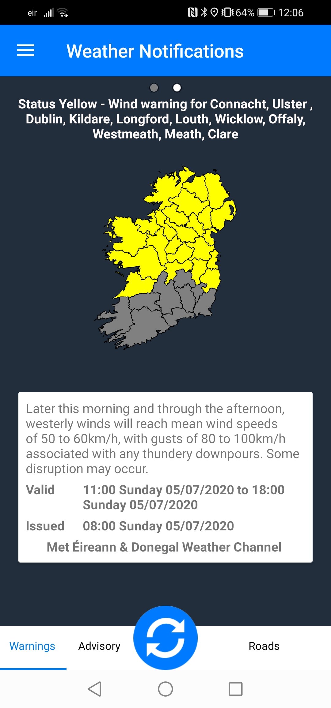
Status Orange - Rainfall warning for Connacht, Cavan, Monaghan, Donegal, Wexford, Cork, Kerry and Waterford
Met Éireann Weather Warning
Intense rainfall associated with Storm Francis is expected at times Monday night and Tuesday, leading to accumulations of 40 to 60mm (higher values in mountainous areas). The most intense rainfall is expected to ease off in southern counties during Tuesday morning. Some flash flooding likely.
This rainfall will further elevate river levels and may result in river flooding also.
Valid: 21:00 Monday 24/08/2020 to 17:00 Tuesday 25/08/2020
Issued: 11:00 Monday 24/08/2020

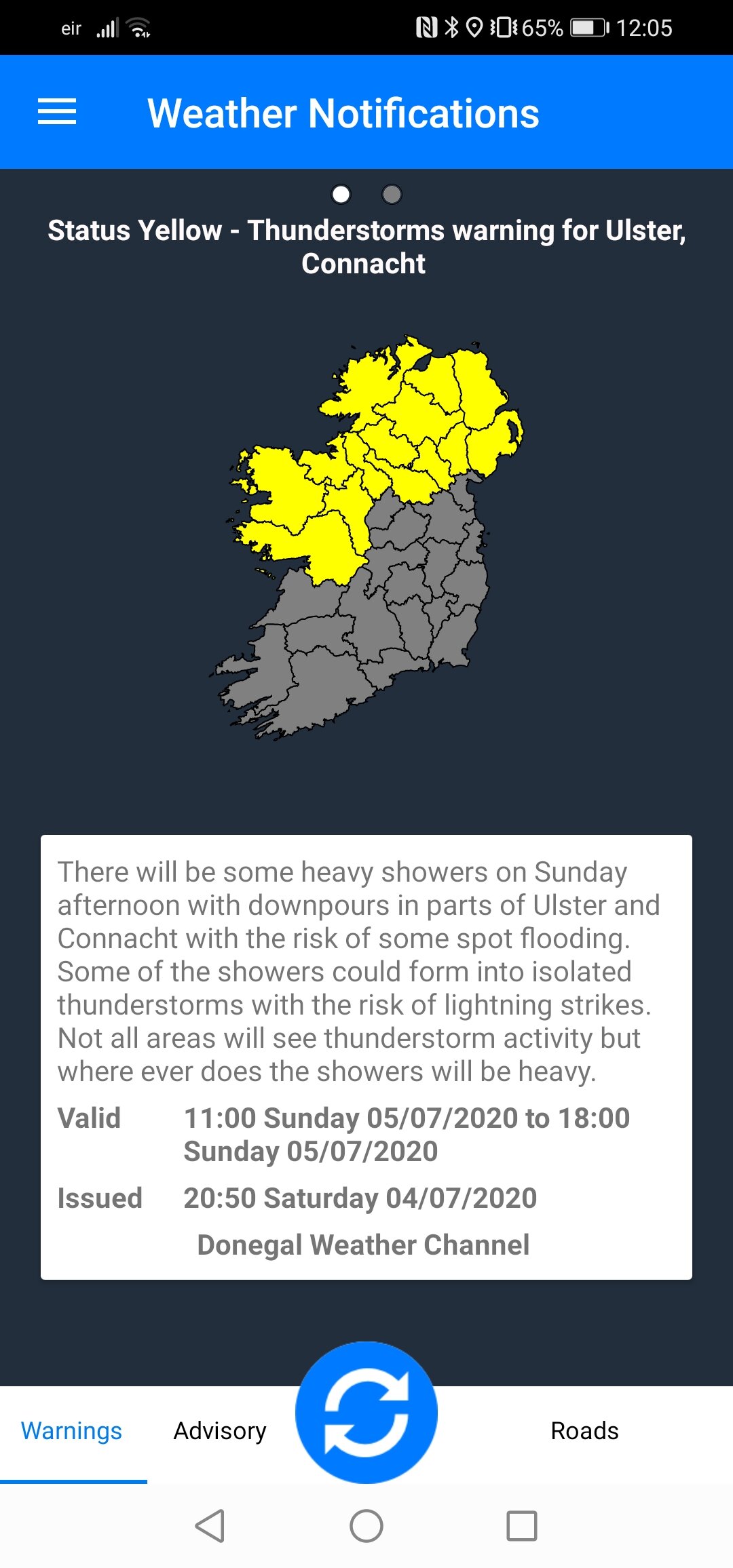
Status Yellow - Rainfall warning for Ireland
Met Éireann Weather Warning
Intense rainfall is expected at times Monday night and on Tuesday. Falls of 30 to 50 mm are expected with surface flooding.
This rainfall will further elevate river levels and may result in river flooding also.
Valid: 21:00 Monday 24/08/2020 to 21:00 Tuesday 25/08/2020
Issued: 06:41 Monday 24/08/2020
Northern Ireland Warnings
Yellow - Rain Warning for Antrim, Armagh, Down, Fermanagh, Tyrone, Derry
UK Met Office Weather Warning
Heavy rain is expected during Tuesday and early Wednesday and is expected to result in some flooding and disruption to travel.
Valid: 00:00 Tuesday 25/08/2020 to 06:00 Wednesday 26/08/2020
Issued: 10:28 Monday 24/08/2020
WIND WARNINGS

Status Yellow - Wind warning for Munster, Dublin, Wexford and Wicklow
Met Éireann Weather Warning
Very windy or stormy conditions are expected on Tuesday as Storm Francis crosses Ireland. Southwest winds veering westerly, reaching mean speeds of 55 to 65km/h, will bring widespread severe gusts of 90 to 110km/h (and possibly higher in exposed areas). Some disruption is likely and possibly structural damage.
Valid: 06:00 Tuesday 25/08/2020 to 19:00 Tuesday 25/08/2020
Issued: 10:55 Monday 24/08/2020


* Only ANDROID users at moment.
* Features under development.
LATEST NEWS


