
STORM ELLEN - Severe and destructive winds are expected with a red warning issued

Severe and destructive winds are expected along the south and west coasts during Storm Ellen, which is expected to reach Ireland tonight. A Status Red wind warning has been issued for Cork, while a Status Orange warning will come into effect for the rest of Munster, Galway and Mayo.
People living in mobile holiday homes or on campsites in parts of southwest Cork have been urged to seek shelter or find alternative accommodation as the Status Red warning comes into effect at 9pm and will last until midnight.
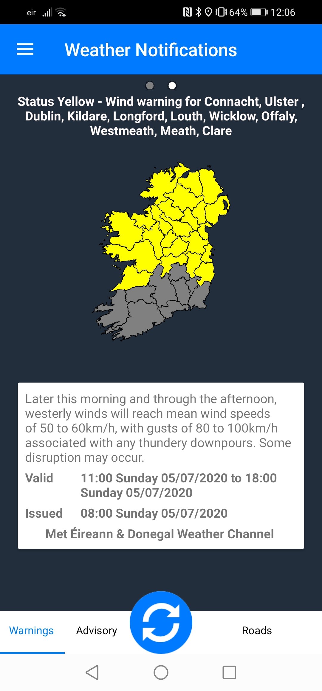
The Orange wind warning for Munster, Galway and Mayo are valid from 9pm tonight until 6am tomorrow. A Status Yellow wind warning for the rest of the country will be in effect from 9pm until midnight on Thursday.

there is particular concern for tourists who may be camping as a separate Orange weather alert remains in place for the other counties in Munster, as well as for Galway and Mayo.
Storm Ellen will hit Kerry and Cork tonight and move up along the country.
Head of Forecasting at Met Eireann Evelyn Cusack said it is a serious storm and these counties and Co Clare in particular are likely to experience coastal flooding as a result of very heavy rain.
She said all areas are at risk from the high impact storm and the country is in for a very unsettled spell of weather from tonight, and into tomorrow and Friday.
Ms Cusack said there was a possibility of some high impact wind and rain at times.
Storm Ellen is forming over the Atlantic fuelled by the remnants of Hurricane Kyle.
Ellen is forecast to move over the south of Ireland Wednesday evening, tracking northwards over the country during Wednesday night and daytime Thursday. Potentially gusts may exceed 130km/h in some exposed coastal and mountain locations and some lower locations due to funnelling effects.
She said while the storm will pass by late tonight, the further bad weather will increase the risk of flooding tomorrow along the east coast with a Status Red marine warning in place for coastal areas.
Ms Cusack said Storm Ellen is being fuelled by remnants of Hurricane Kyle and while it is not yet in Ireland's coastal waters, it is likely to make landfall off the Kerry/Cork coast at around 8pm or 9pm.
It is expected to travel up the west coast or the midlands, but there "is some degree of uncertainty about this".
She also said that while the timing and location of the Red warning is specific, there could be severe impacts for all parts of the country.
Ms Cusack said: "All parts of the country may experience severe impacts. Trees are in full leaf at the moment and are likely to be blown down, some roofs blown off and roads damaged.
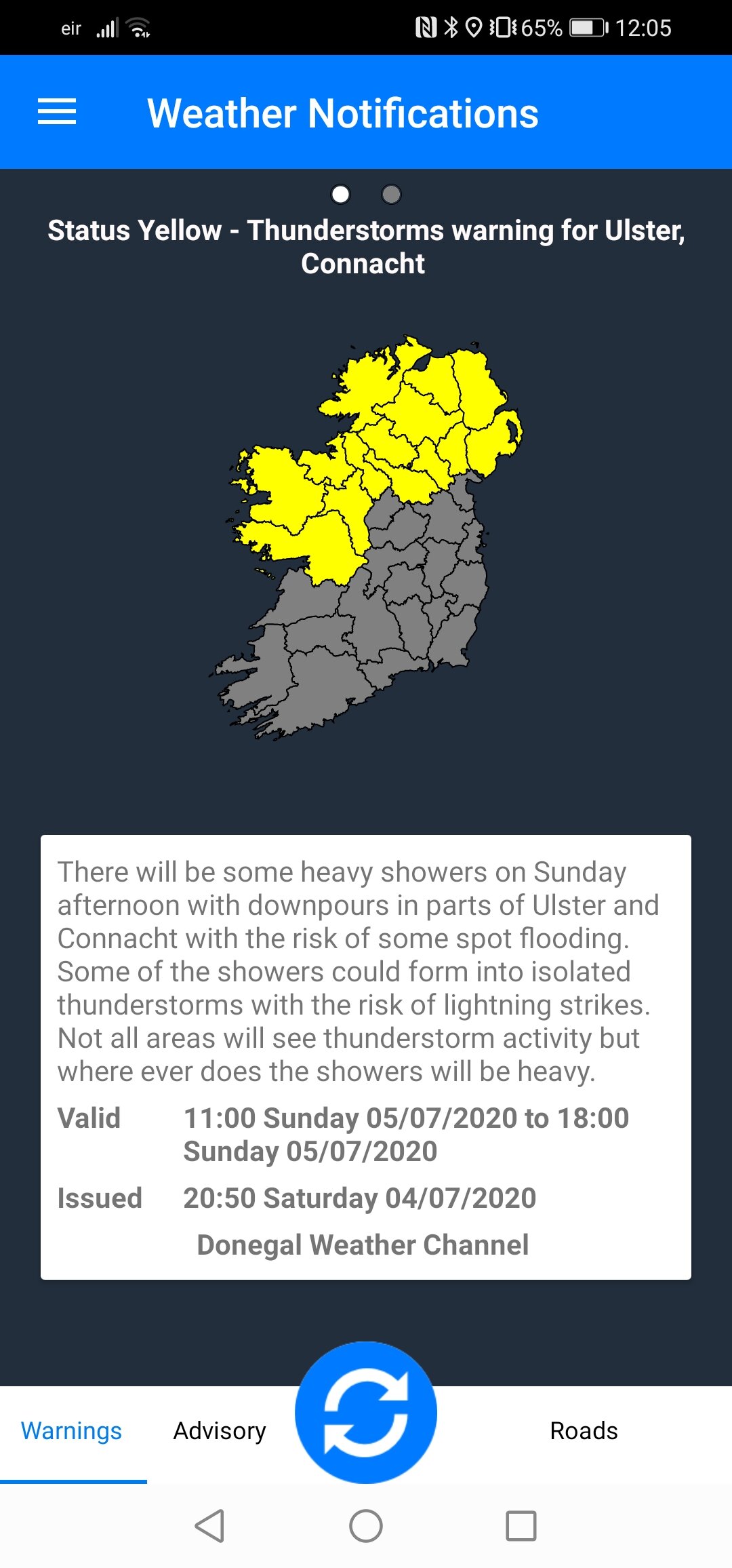
"There will be heavy and thundery downpours and some flooding. There will be coastal effects or storm surges and tides are high, and will vary depending on the location."
Ms Cusack said while this weather is unseasonal, August is one of the wettest months in Ireland because of warm humid conditions and thunderstorm activity.
Met Éireann has warned that due to the combination of storm surge, spring tides and onshore winds there is a potential risk of coastal flooding.
A Status Yellow wind warning for the rest of the country has also been issued. The warnings come into effect at 9pm.


* Only ANDROID users at moment.
* Features under development.
LATEST NEWS


