
Ireland's weather set to turn dry, sunny and warmer over the next 7 days

After a rather cool and overcast weekend the weather across Ireland will again improve over the next 24 hours with high pressure building again. On April 13th 6 days ago Donegal Weather Channel had spotted this spell of weather in our long term forecast with longer range data showing higher pressure than average across Ireland for much of the rest of the month into possibly early May.
Pollen levels will be high from Wednesday until next week with the main type of pollen been tree.
Birch tree pollen is now airborne with a high risk, especially during sunny weather. Ash and the milder willow pollen also airborne.
Grass pollen risk is low and will remain low until May
Weed pollen risk is low for now but the season will start again in late April/May

Turning drier across Ireland from Tuesday
TUESDAY 20TH APRIL 2021

A cloudy morning everywhere on Tuesday morning with outbreaks of rain early in the morning clearing after dawn. During Tuesday afternoon and evening brighter and sunnier weather will spread from the northwest with many areas away from northwestern and northern areas staying mostly cloud but dry. Temperatures will range between 9C to 13C.
Clear weather will move southwards on Tuesday night with nearly all areas seen clear sky’s around or just after midnight. There will be the small risk of a frost across north, west, midlands and east with temperatures between -1 to 5C warmest along southern coastal counites where some cloud may linger
Pollen
Pollen levels will be Moderate on Tuesday and the main pollen type will be Tree.
UV Forecast
UV Levels will be moderate on Tuesday under clear sky’s. There will be the risk of sunburn
WEDNESDAY 21ST APRIL 2021

Wednesday will be a dry day with bright and sunny spells for all areas .Temperatures will range between 10C to 16C and it will be warmest in the south and west coolest across northeastern and eastern areas due to a onshore east to northeast breeze.
Overnight will be dry with good clear spell with temperatures between 1C to 5C coldest in the north and west where there will be the slight risk of a grass frost. A few fog patches may also form in places.
Pollen
Pollen levels will be High on Wednesday and the main pollen type will be Tree.
UV Forecast
UV Levels will be moderate to high on Wednesday under clear sky’s. There will be the risk of sunburn

THURSDAY 22ND APRIL 2021
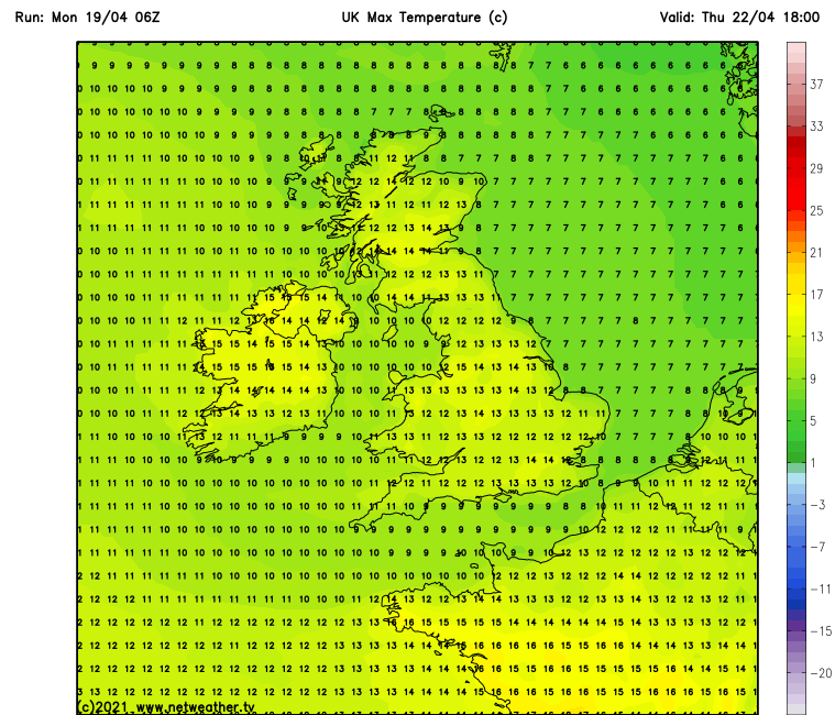
Thursday will be another bright and sunny day for Ireland as high pressure sits across Ireland and the UK. Temperatures will range between 12C to 16C.
Thursday night will be another dry night with clear spells across Ireland. Temperatures will range between 0C to 7C overnight with the slight risk of a grass frost over western and northern areas. It will be warmest across the south overnight and less cold. Some fog patches possible overnight.
Pollen
Pollen levels will be High on Thursday and the main pollen type will be Tree.
UV Forecast
UV Levels will be moderate to high on Thursday under clear sky’s. There will be the risk of sunburn
FRIDAY 23RD APRIL 2021
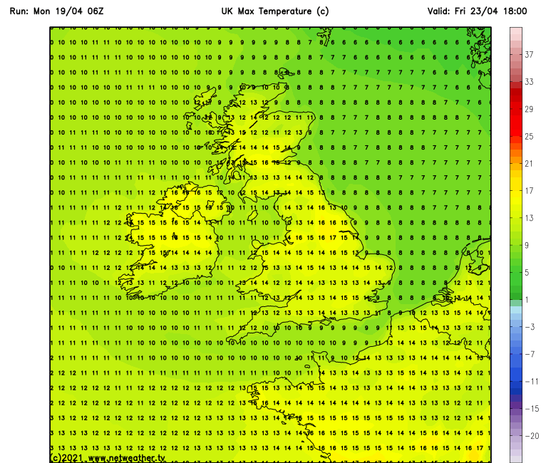
Friday will be another dry day across Ireland with good bright and sunny spells. Temperatures will range between 11C to 16C warmest in the west, northwest and midlands.
Friday night will be another dry night with good clear spell across Ireland. Temperatures will range between 0C to 9C coldest across Ulster where there will be the slight risk of some grass frost. It will be less cold across the southern half of Ireland where it will remain frost free.
Pollen
Pollen levels will be High on Friday and the main pollen type will be Tree.
UV Forecast
UV Levels will be moderate to high on Friday under clear sky’s. There will be the risk of sunburn
remaining dry this weekend with good sunny spells across Ireland
This weekend the weather will remain dry with good sunny spells as high pressure looks set to stay sitting over Ireland which is good news for you none rain lovers. The ridge of higher pressure can be seen in the below chart sitting across Ireland this weekend.

High pressure in place across Ireland this weekend
At present the latest weekend outlook has the high pressure system which will sit across Ireland from Tuesday to Friday strengthen over the weekend which will mean that it will be harder to shift and resulting in a longer period of dry weather which the Donegal Weather Channel longer term forecast hinting at last week.
SATURDAY 24TH APRIL 2021
High pressure stays in place on Saturday with the high pressure system strengthen which will give good bright and sunny spells across Ireland with temperatures between 13C to 17C warmest in the west, northwest and midlands.
Dry overnight with clear spells on Saturday. Temperatures will range between 4C to 7C.
Pollen
Pollen levels will be High on Saturday and the main pollen type will be Tree.
UV Forecast
UV Levels will be high on Saturday under clear sky’s. There will be the risk of sunburn
SUNDAY 25TH APRIL 2021
High pressure stays in place again on Sunday with good bright and sunny spells across Ireland with temperatures between 13C to 17C warmest in the west, northwest and midlands again.
Dry overnight with clear spells on Sunday. Temperatures will range between 4C to 7C.
Pollen
Pollen levels will be High on Sunday and the main pollen type will be Tree.
UV Forecast
UV Levels will be high on Sunday under clear sky’s. There will be the risk of sunburn
Long range forecast for the rest of April and early May
The long range forecast outlook look rather good on the ECMWF and GFS models showing a nice end to April with high pressure dominating the weather .
The chart below is taken from the ECMWF weather model long range outlook which shows the pressure over Ireland between Monday the 19th of April to Monday the 26th of April and shows high pressure than average. The below chart is the higher pressure which will sit across Ireland this weekend and weekend

Monday the 19th of April to Monday the 26th of April
PINK/PURPLE : Higher than average - GREEN/BLUE - Lower than average

Monday the 19th of April to Monday the 26th of April
PINK/PURPLE : Higher than average - GREEN/BLUE - Lower than average
Early May Outlook
The week between 26th of April and 3rd of May has high pressure to the north of Ireland and lower pressure to the south. The ECMWF long range forecast show still rather dry weather moving into the first few days of May the GFS forecast models also backs this idea up both model outlooks for the period around the May Bank Holiday can be seen below.
No real warm weather is expected over the rest of April into early may with temperatures around normally for the time of year in the mid teens possibly into the high teens later in the month.
The below charts are from the ECMWF Model which shows higher pressure than average across Ireland in to early may.

Monday the 26th of April to Monday the 3rd of May
PINK/PURPLE : Higher than average - GREEN/BLUE - Lower than average
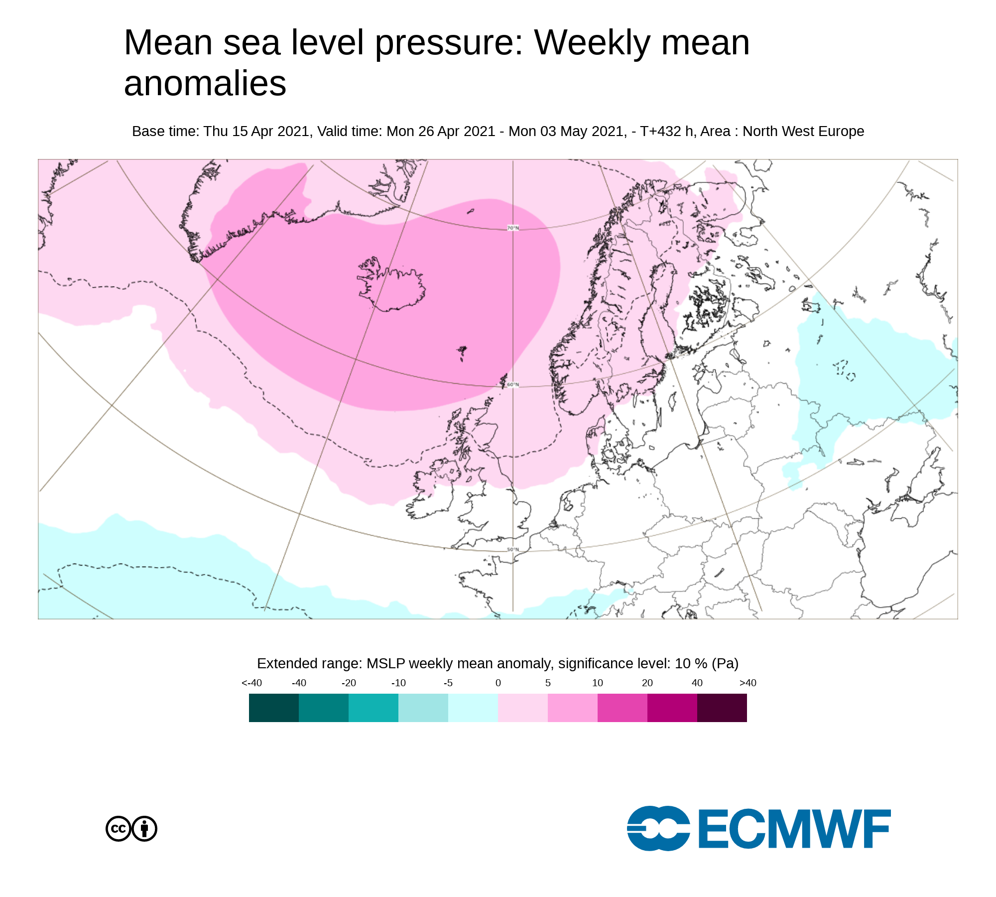
Monday the 26th of April to Monday the 3rd of May
PINK/PURPLE : Higher than average - GREEN/BLUE - Lower than average
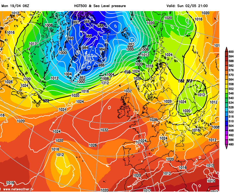
The below chart is taken from the GFS model which is the American model which shows high pressure into the end of April and early May period. The High pressure system is a fairly strong pressure system which would feed up warm southwesterly airflow with temperatures in the high teens.
FARMERS NOTE - VERY LITTLE RAINFALL AND A FIRE RISK LATER THIS WEEK

Rainfall amount between Tuesday 20th April and Monday 26th of April will be way lower than average. Today Monday will see the most rain with around 7mm in Atlantic coastal areas with lower than 4mm in the eastern half of Ireland. Drying conditions will be mostly poor over the next couple of days, but will improve to good from midweek.
FIRE RISK
With drier weather expected from the second half of Tuesday until early next week where rainfall amounts will be less than 1mm for much of Ireland this will mean good dry conditions which will increase the risk of gorse and forest fires later this weekend and over the weekend. The fire risk will be code orange high risk be prepared .
Based on recent fire activity, ignition risks appear to be mainly focussed on areas with public access, particularly peatland sites. The relaxation of some Covid-19 requirements mean that members of the public can now travel within their respective counties, and higher visitor activity levels at recreational sites can be expected. Members of the public intending to visit forests and other recreational sites are reminded to adhere to regulations introduced to limit the spread of Covid-19. Vehicles must not be parked at site entrances or impede emergency service access to forest roads. Visitors should not use barbeques or open fires at any stage.
BE PREPARED. BE VIGILANT. STAMP OUT FOREST FIRES
Advice to the General Public/Forest Visitors
Members of the public and visitors to recreational areas should cooperate with all requests regarding fire safety, obey all relevant bye-laws and be considerate in parking vehicles so as not to impede access by emergency vehicles.
Where fire outbreaks occur at or near recreational areas the following actions should be taken by visitors in the interests of safety.
1. Do not light fires in and around forests or open land.
2. Do not attempt to intervene or fight fires under any circumstances.
3. Gather all family/group members and move to a safe fuel-free location such as a car
park, upwind of the fire.
4. Telephone Fire and Rescue Services via 112 and report the fire and its location.
5. Evacuate if instructed to do so, and cooperate with all Emergency Service Instructions.
All forecast, research and data are put together by Donegal Weather Channel. If you find are forecast useful please share with your friends and give a like on our social media platform.
Kenneth from the Donegal Weather Channel
You can find all the latest weather warnings and forecasts by downloading our app from the google play store by clicking below

LATEST NEWS


