
Heavy rainfall and flooding to start the new week with colder weather and snow to finish

A very active week in weather is coming up with a number of different elements due to cause hazardous driving conditions. Monday and the first half of Tuesday will start of with the weather on the milder side with heavy rainfall and flooding for places.
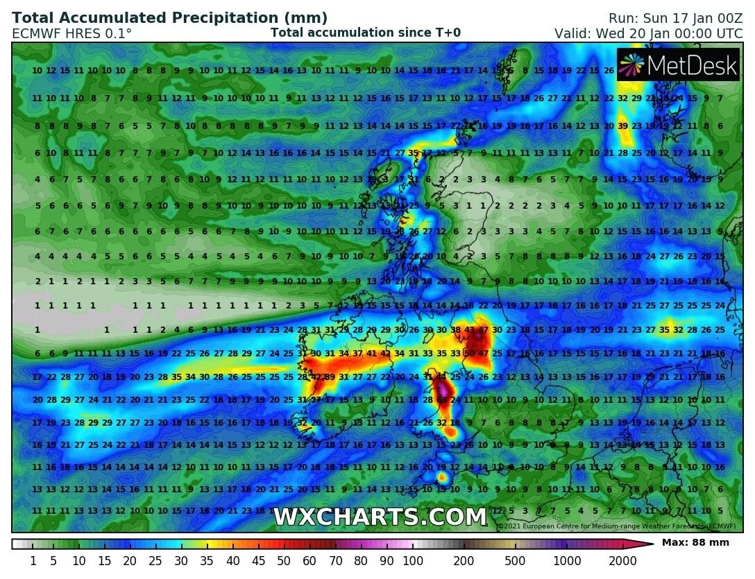
This is due to a developing low pressure system moving west to east across Ireland from Monday to Wednesday.

HEAVY RAINFALL AND FLOODING
On Monday night a band of heavy rain will move into the southwest and west and extend eastwards across Ireland throughout Tuesday giving localised and river flooding. With river levels and streams so high already at the moment some rivers may burst there banks in places.
The highest rainfall amounts will occur across Connacht, North Leinster and south Ulster with 30mm to 50mm possible there.

The band of rainfall will be over 2000km/hr wide on Tuesday
Across Munster, Mid to north Ulster and south Leinster there will be amounts of between 10mm to 25mm in fact with colder air so close to the north coast of Donegal and Derry it may keep the heaviest of the rain further south with around 10mm or less.


Met Eireann have issued a status yellow rainfall from 9pm Monday night until 9pm Tuesday night
Status Yellow - Rainfall warning for Connacht, Longford, Louth, Westmeath, Meath, Cavan and Monaghan
Met Éireann Weather Warning
Heavy rainfall will lead to accumulations of 30 to 50mm, with higher accumulations in mountainous areas. This will bring a risk of some river and localised flooding.
Valid: 21:00 Monday 18/01/2021 to 21:00 Tuesday 19/01/2021
Issued: 16:00 Sunday 17/01/2021
TURNING COLDER ON TUESDAY NIGHT FROM THE NORTH
On Tuesday night it will then turn colder with frost and ice returning to the forecast up until early next week.
icy roads
As the band of rain clears to the southeast on Tuesday night and Wednesday morning temperatures will fall very quickly across Connacht and Ulster just before dawn Wedneday morning with low of 0C to -3C with the risk of very icy roads developing and black ice be very mindful of than on Wednesday morning especially with all the heavy rain from Tuesday roads and footpaths will be very icy. across Munster and Leinster temperatures will range between 3C to 5C. Temperatures for Wednesday morning can be seen below

Frosty and icy conditions will persist into the weekend where lows of -4C to -5C will occur especially across the north and northwest later in the week and over the weekend and with further showers some wintry this will keep the risk of icy road conditions occuring
SNOWFALL
On Tuesday as the ban of rain move across Ireland and with colder air sitting over Ulster this may allow the rain to fall as a mix of rain and sleet and places with snow over the mountains.
On Wednesday colder air and northerly airflow will flood over Ireland as the developing low clears to the east allowing for a change in the direction of the wind and airflow. This can be seen below.

Wednesday to Sunday at least there will be then showers of rain, hail, sleet and snow especially over the north and west of Ireland with the Highest risk of wintry falls over the north and northwest. Some snow accumulations could occur at times in this period especially from Thursday until Sunday.
Some of forecast Models shows a periods of sleet and rain across the east and southeast on Wednesday with snow across higher ground areas so places like the Dublin Mountains and Sally gap could see a coating of snow by Thursday morning.
exact detail are not yet certain and closer to the time the models will give us a better Idea.
You can find all the latest weather warnings and forecasts by downloading our app from the google play store by clicking below

LATEST NEWS


