
COLD WEATHER UPDATE - What are sea streamers? how will they bring snow to some next week

You may notice over the past few days within our forecast updates we have mentioned the word sea streamers and probably think what are sea streamers and why do they come up in the forecast when colder weather with a easterly airflow arrives over Ireland.
You may have heard of the term Lake effect snow well its much the same as sea effect snow and they form in the same way only Lake effect snow is formed due to a large body of water from a lake and sea streamer are formed at sea which I am sure you have guessed already.

Over the early days of next week Ireland will see some of this sea effect snow moving in from the Irish sea with the same process taken place of the coasts along the north and south coast bring snowfall for some people but not all.
This type of snowfall can be very hard to forecast for exact locations but what we do know the right ingredients will be in place for sea effect snow to form in the way of sea streamer giving snowfall for some areas.
The process of sea or lake or ocean effect snow is relatively well understood. Despite this, the narrow snow bands associated with these events, ranging from a few to perhaps 50 km in width, present a difficult forecast challenge. Occasionally, one location might receive snowfall of 15cm to 30cm or more, while locations as close as 20 km away may receive only flurries or nothing at all like we seen back during the best from the east in 2018.

The forecast of onset, location, intensity, movement, and persistence of these relatively shallow convective bands is difficult given the limitations of our conventional observing systems. These bands are also sufficiently narrow that current operational forecast models are unable to properly resolve them in most instances and is the reason right now snow may not be showing up on any of your weather apps due to the forecast models not been able to pick these up until hours or minutes before the occur. Nevertheless, an understanding of the favorable synoptic setting and the basic ingredients and characteristics of sea or lake effect snow bands can lead to better forecasting of these mesoscale features.


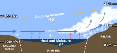
Sea/lake effect snow occurs when cold polar, arctic or Siberian air flows over a relatively warm water surface like the Irish sea, generating convective snow bands over and downwind of a body of water. These snow bands can be quite narrow and intense, with snowfall rates of up to 15 cm/hr. The sea/lake effect process has several key ingredients, as illustrated in the conceptual model below. Cold air is heated and moistened as it passes over the warmer sea, creating an unstable lapse rate. Convective snow bands develop and are enhanced by lifting due to frictional convergence and orography over and inland of the leeward shore. The vertical extent of the convection is limited by a stable capping inversion that is typically 1-4 km above the surface, making sea/lake effect convection much shallower than that normally associated with thunderstorms. Additional ingredients that are important to production of sea/lake effect snows include sufficient wind fetch, low directional wind shear, and favorable cloud and precipitation microphysics which we will have early next week especially later Monday
Even in the absence of convective processes, cold air flowing over warm water can result in a region of enhanced snowfall imbedded within a more general synoptic snowfall downwind of a body of water. This process is referred to as “Sea/lake-enhanced,” rather than Sea/lake effect snow.
SHADOW EFFECT

SHADOW EFFECT SNOW EXAMPLE
As mentioned above the snow amounts can be massively different from on place to another and the above image I have made up to help you understand a little more what the shadow is. When we look at the Irish sea we have The Isle of Man sitting between England and Ireland and in a easterly set up with easterly winds this can hamper the chances of sea effect snow forming for example in between the broken red lines due to there been less of a body of water meaning less of a risk of showers forming but still some showers would form but be less beefy due to the shorter time that had to form . Either side of these between the red and black broken lines there is a larger body of water for the easterly winds to move across allowing clouds to form and heavy snow showers to move in overland dumping large amounts of snow and sometimes these showers can just keep coming known as a train effect with sea streamers reaching all the way into the western half of Ireland something we may see next week.
A Shadow effect from Wales can also cause this to occur across parts of the southeast of Ireland with some areas see big amounts of snow and other areas just a few kilometers away receiving very little or no snow.
LATER NEXT WEEK
Later next week a frontal system is due to move in from the Atlantic and turning to snow for many areas away from the southern coastal areas in this case it is much easier to forecast the snow amounts in this case up to 2 to 3 days away.
Right now many people across the eastern half of Ireland in particular may see that its showing cloudy and very cold Monday, Tuesday and Wednesday next week on there weather apps with snow then possible later Wednesday, Thursday and Friday. This will be the same case for some other parts of Ulster, Connacht and Munster for the early days of next week where some sea streamers may reach further west. Early next week closer to the time maybe hours to a hour before your app may start showing all of a sudden that there is a risk of snow incoming in the next hour or for the next few hours something it had fail to show for days and hours before due to the sea effect snow forming. As for later next week models are able to handle a frontal system much easier and is why it may be showing snow for later in the week on your app. This is why a human output is more reliable especially in set ups like this
Kenneth from the Donegal Weather Channel
You can find all the latest weather warnings and forecasts by downloading our app from the google play store by clicking below

LATEST NEWS


