
STORM DIANA LIVE UPDATES & REVIEW

STORM DIANA LIVE UPDATES

REFRESH THIS PAGE EVERY FEW MINUTES FOR THE LATEST ON STORM DIANA - SCROLL DOWN FOR THE LATEST UPDATES AND WARNINGS


STATUS ORANGE - WIND WARNING FOR CORK, KERRY AND WATERFORD
Severe winds associated with Storm Diana on Wednesday: South to southwest winds of 65 to 80 km/h will gust 110 to 130 km/h. High Seas also, with a risk of coastal flooding.
Issued: Tuesday 27 November 2018 11:00
Updated: Tuesday 27 November 2018 11:00
Valid from Wednesday 28 November 2018 06:00 to Wednesday 28 November 2018 13:00
This weather warning has been issued by Met Eireann for Ireland
STATUS ORANGE - WIND WARNING FOR WEXFORD, GALWAY AND CLARE
Severe winds associated with Storm Diana on Wednesday: South to southwest winds of 65 to 80 km/h will gust 110 to 130 km/h. High Seas also, with a risk of coastal flooding.
Issued: Tuesday 27 November 2018 11:00
Updated: Tuesday 27 November 2018 11:00
Valid from Wednesday 28 November 2018 09:00 to Wednesday 28 November 2018 15:00
This weather warning has been issued by Met Eireann for Ireland
STATUS YELLOW - WIND WARNING FOR IRELAND
Gale force winds associated with Storm Diana on Wednesday: South to southwest winds of 55 to 65 km/h will gust 90 to 110 km/h.
Issued: Tuesday 27 November 2018 11:00
Updated: Tuesday 27 November 2018 11:00
Valid from Wednesday 28 November 2018 05:00 to Wednesday 28 November 2018 16:00
This weather warning has been issued by Met Eireann for Ireland
YELLOW WIND WARNING IN PLACE FOR : COUNTY ANTRIM, COUNTY ARMAGH,COUNTY DOWN, COUNTY FERMANAGH, COUNTY DERRY & COUNTY TYRONE
Further details
A very unsettled spell of weather is expected, with strong winds, combined with widespread and in places heavy rain. Winds are expected to increase from the far southwest early on Wednesday, spreading northeast, with areas adjacent to the Irish Sea most exposed to the south to southeasterly wind. Wind gusts of 60 mph are expected, with a few more exposed locations seeing 70 mph gusts. Winds will also turn west to southwesterly across Northern Ireland and western Scotland later, transferring the main focus for strong winds here, then finally to northern Scotland through the evening. The strong winds will also bring some rough seas and large waves, with some coastal impacts possible. Winds will moderate across the south of the warning area by evening and then across remaining parts overnight.
What to expect
Some delays to public transport are likely, and journey times could take longer.
Delays for high-sided vehicles on exposed routes and bridges likely
Some local short term loss of power and other services is possible.
It’s likely that some coastal routes, sea fronts and coastal communities will be affected by spray and/or large waves
Between Wed 09:00 and Wed 23:59
This weather warning has been issued by Met Office UK for Northern Ireland

#STORM DIANA
Continues below


LIVE UPDATES WILL APPEAR UNDER HERE OVER THE COMING HOURS
Refresh page to load the latest updates
REVIEW OF STORM DIANA

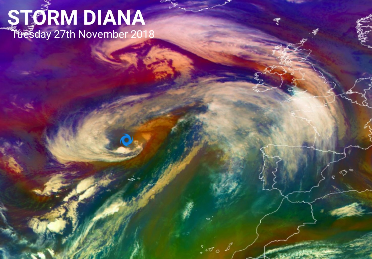
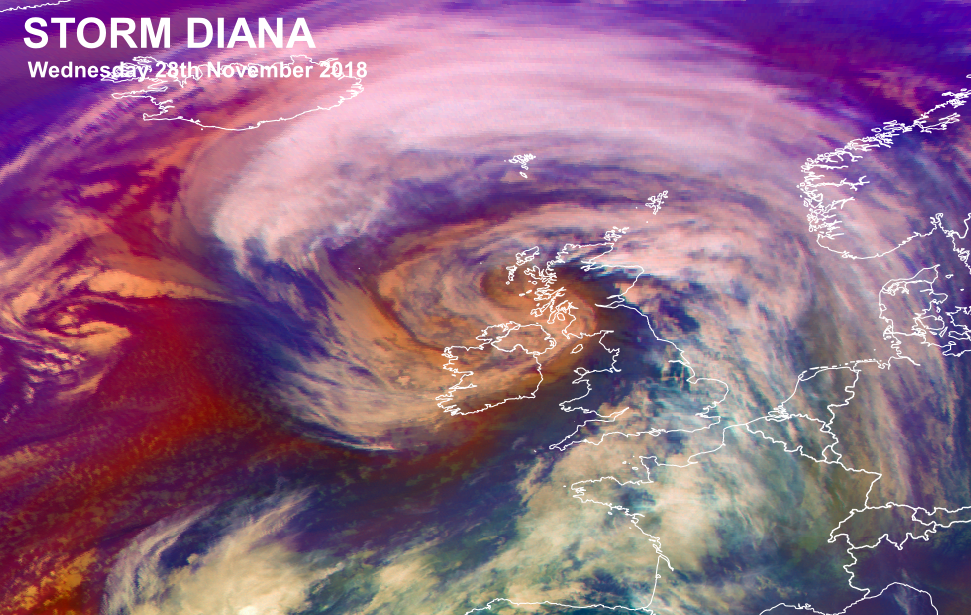
Storm Diana passed over Ireland today Wednesday the 28th of November and was named by the Portuguese Met Office IPMA due to the IMPA issuing a orange wind warning for the Azores Island yesterday and is the reason this storm was not named by Met Eireann or the UK Met Office. The strongest winds from this storm was recorded this morning across the southern Half of Ireland where the strong gust of 140km/hr was recorded of the Cork coast at fastnet light house which is a very exposed island with a light house on it the highest inland gust recorded from a official Met Eireann weather station was at Sherkin Island Co.Cork at 10:00am with a gust of 122km/hr. The highest mean wind speed recorded was at Roches Point Co.Cork at 83km/hr.
Below you will fine a graph showing the top 10 highest gust recorded today
STORM DIANA - TOP 10 MAX GUSTS
POWER OUTAGES
ESB Networks has said 19,000 homes and businesses are without power due to strong winds from Storm Diana.
Outages had peaked at 11am with 40,000 customers without power.
Figures released at midday stated that among those affected, over 8,000 customers were without power in Kilkenny city while nearly 3,000 are affected in Celbridge, Co Kildare.
Earlier, speaking ESB spokesperson Derek Hynes said it was not safe for crews, in the worst affected counties, to begin restoring power until winds have died down.
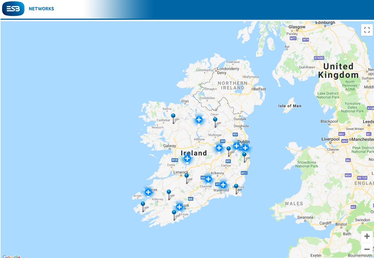
ESB Power check map shown areas worst hit by storm Diana
FLIGHTS CANCELLED
Fourteen flights had to be cancelled at Cork Airport, to and from Birmingham, Manchester, Edinburgh, Bristol, Amsterdam, Paris and London Heathrow Wednesday morning.

14 flights are cancelled Wednesday morning @CorkAirport - 7 out and 7 in to Birmingham, Manchester, Edinburgh, Bristol, Amsterdam, Paris and London Heathrow.
— Cork Airport (@CorkAirport) November 27, 2018
Passengers are advised to check the latest status of their flight on their airline’s website. #StormDiana pic.twitter.com/xs9b0iM0Xx
There was only a little coastal flooding due to rough seas and damage was kept to a minimum this morning as storm Diana passed the video below shows rough seas in the south of Ireland.
We strongly advise the public to stay away from exposed beaches, cliffs, piers and promenades along the coast today.
— Irish Coast Guard (@IrishCoastGuard) November 28, 2018
Remember to Stay Back, Stay High and Stay Dry!
If you see someone in difficulty in the sea or on the shore dial 999 or 112 and ask for the Coast Guard #StormDiana pic.twitter.com/jsllLNIPIz
The video below shows rough seas at the seaside town Tramore in County Waterford on the southeast coast of Ireland.
Tramore (credit Neilus Dennehy) pic.twitter.com/yOjXrH36JN
— Damien Tiernan (@damienrte) November 28, 2018
Over all storm Diana passed with minimal damage which is good to say. The worst effected areas was the south and south east of Ireland where the most homes and businesses lost power. Across the southwest, west and northwest there was up to 20mm of rainfall over the morning and afternoon which lead to spot flooding in some areas but no major flooding was reported.
LATEST NEWS


