
STRONG SIGNALS FROM WEATHER MODELS TONIGHT IRELAND MAY SEE A SPELL OF SNOW ON MONDAY INTO TUESDAY


Temperatures across Europe this morning
Early next week models continue to show a colder blast of polar maritime air to reach Ireland with a low pressure system to the north of Ireland centred over Iceland feeding in a band of precipitation falling as rain and sleet turning quickly to snow late Monday evening and overnight Monday.
Current models show heavy snow showers then moving in from the northwest Tuesday morning leading to accumulations of snow to both higher and low level areas.
The reason for this latest update is so people can prepare themselves over the weekend if they have to travel anywhere next Monday night and Tuesday. This is around 90 hours to 100 hours away which is a releasable time frame. This could be the first proper snowfall of 2019 for places.


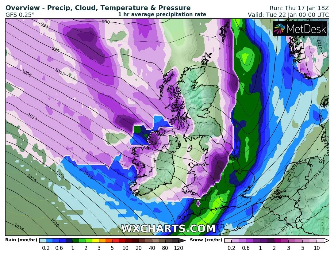
Above shows the Latest models the ECMWF, GFS, GEFS, ICON and the Met Eireann charts
Continues below


At present a area of low pressure coming out of Iceland and centres itself near Iceland feeding in a cold northwesterly (Polar maritime airmass) across the country early next week all the way from Greenland. A band of precipitation associated with the areas of low pressure system looks set to pass over Ireland falling as rain first briefly and then turning to sleet or snow as colder air is dragged in from behind , further heavy wintry showers look set to follow behind this system with snowfall possible across mainly west Munster, Connacht and Ulster with a few showers also possible across the midlands. The current outlook from the latest GFS and ECMWF model are much the same shown this risk.


Continues below


Current models runs show that there will be a covering of snow on Monday Night into Tuesday morning to some lower level areas along with higher ground areas snow showers could also continue on Tuesday night . At the moment it is to early to go into details as this areas of low pressure could yet shift further south or further northwards leading to a change in the forecast.
I know many will want to know more but its not possible yet a could be late Sunday before we get into any fine details.
once this system passes early next week there are sign that we will then see a east to northeast airflow leading to colder conditions by day and over night with a sharp frost and icy conditions. There will also be the risk of weather fronts moving in from the Atlantic bumping against the colder conditions turning precipitation to snowfall in some areas.
I will update on early next week again either late Saturday or Sunday when the outlook will be much clearer.
Kenneth Mc Donagh from the Donegal Weather Channel
2019 CALENDAR NOW ON SALE


2019 Calendar now on sale
You can now purchase the Donegal Weather Channel Calendar 2019. You can purchase the Calendar from the online store
All calendars will be posted out in the middle of November with only a limited amount available. Calendars can be purchased anywhere across the world.


The stunning Leitir Mhic An Bhaird (Lettermacaward) Donegal during May 2018

Vivid Rainbow from up on Breezy mountain South Donegal


I was in Albufeira Portugal I was waiting for the full moon to come up and it did not let me down.
The orange and red tints that the Moon sometimes take on rising and setting are caused by the particles in the Earth's atmosphere. When light (or more specifically, packets of light called photons) from an astronomical object passes through the Earth's atmosphere, it scatters off of particles in the latter.

What a unbelievable night and morning out storm chasing, These number of thunderstorms had to be the best in years as most of the lightning was CG bolts. I even manage to captures Two to three CG bolts in one shot.

One of the most beautiful views of Slieve league From sea and got some nice photos.
Photos from this angle I have not seen yet and it was wonderful to finally capture that moment.
Follow Donegal Weather Channel on other social media platforms by clicking the icons below


