
STAYING DRY OVER THE FIRST WEEK OF JANUARY BUT BECOMING A LITTLE COOLER


High pressure over Ireland next week
2017 will end on a dry note and mostly cloudy as high pressure remains in place over the period. Into 2019 high pressure will build across Ireland and the UK with perhaps a little more sunshine in the forecast but it will be a rather cloudy to at times. The weather over the next week and next weekend will be dry with only the odd risk of drizzle and mist at times. This spell of weather is likely to last into the 2nd week of January also with temperature near normal for the time of year and just above to for some places.

Ari Temperatures across Ireland and the UK mid week
Over the coarse of next week into the weekend there will be the risk of frost and fog at night with lows on some nights of around 0C to 2C across Ireland.

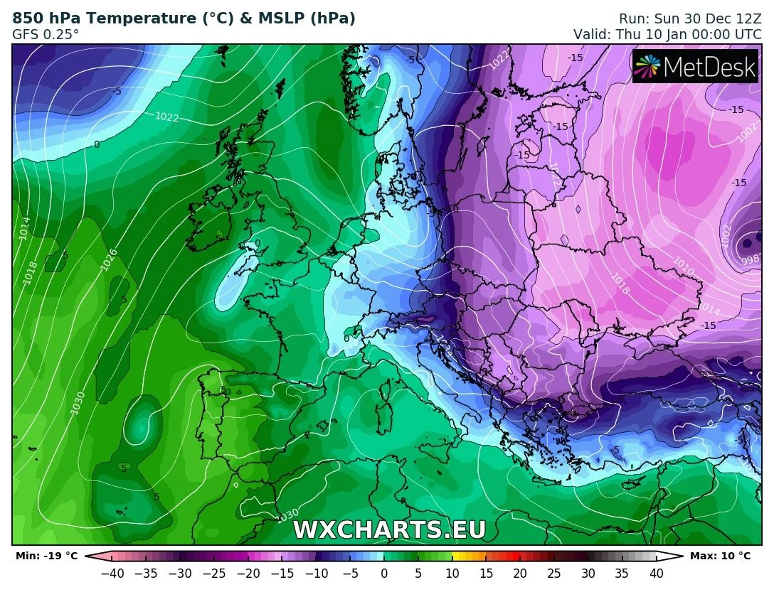
Over the week a very cold plunge of cold air will move southwards down over Scandinavia and onto mainland Europe with cold bitter conditions it just misses Ireland and side swipes eastern parts of the UK. Over later next week and the weekend it will become a little warmer again.
Continues below


Over the last week there has been a lot of talk of the beast from the east part two on the way and this is not true. There is sudden stratospheric warming ongoing at the moment with a possible secondary warming event likely to happen in early January again.
Anticipated changes in the upper atmosphere over the North Pole during late December stage is taken place and will likely impact the polar vortex due to a strong sudden stratospheric warming. When this happens it increases the chances of colder weather and zonal winds (reversal in the westerly winds) . As the polar vortex becomes distorted, the jet stream tends to buckle with large southward dips and northward bulges. Sudden stratospheric warming also occurred at the start if February in 2017 which lead to that much colder spell near the end of the month (the beast from the east).
It can some time take up to 10 days or more for the impacts of the (SSW) to effect us and will be one which will need to be watched rather closely but this does not always mean bitter cold weather and its to early to say if we will see such a event like the end of February.
It will be a watch and wait to see if the warming event in the stratosphere has any effect in the troposphere where the weather is take place and if it responses to it over the coming weeks. Just watch what you read in the media as the come out with big words stating this will happen and that will happen with no source or evidence to back it up. Due to the warming event even the weather models are finding it hard to keep up with the changes in the atmosphere.
Kenneth from the Donegal Weather Channel.
2019 CALENDAR NOW ON SALE


2019 Calendar now on sale
You can now purchase the Donegal Weather Channel Calendar 2019. You can purchase the Calendar from the online store
All calendars will be posted out in the middle of November with only a limited amount available. Calendars can be purchased anywhere across the world.


The stunning Leitir Mhic An Bhaird (Lettermacaward) Donegal during May 2018

Vivid Rainbow from up on Breezy mountain South Donegal


I was in Albufeira Portugal I was waiting for the full moon to come up and it did not let me down.
The orange and red tints that the Moon sometimes take on rising and setting are caused by the particles in the Earth's atmosphere. When light (or more specifically, packets of light called photons) from an astronomical object passes through the Earth's atmosphere, it scatters off of particles in the latter.

What a unbelievable night and morning out storm chasing, These number of thunderstorms had to be the best in years as most of the lightning was CG bolts. I even manage to captures Two to three CG bolts in one shot.

One of the most beautiful views of Slieve league From sea and got some nice photos.
Photos from this angle I have not seen yet and it was wonderful to finally capture that moment.
Follow Donegal Weather Channel on other social media platforms by clicking the icons below


