
SEVERE AND DAMAGING WIND GUSTS POSSIBLE ACROSS WESTERN, NORTHWESTERN AND NORTHERN PARTS OF IRELAND FRIDAY MORNING


On Thursday evening and night a area of low pressure looks likely to be located just of the west coast of Ireland and it will advance towards the west coast of Ireland on Thursday night and Friday morning with the center of the low staying out to sea just of the coast. On Friday morning the area of low pressure then pushes northeastwards up of the northwest and north coast of Ireland and looking to rapidly intensify as it does so. The strongest winds will depend on the track of the storm and how quickly the pressure drops from the center of the low. As pressure drops isobars tighten and the strong winds you get.
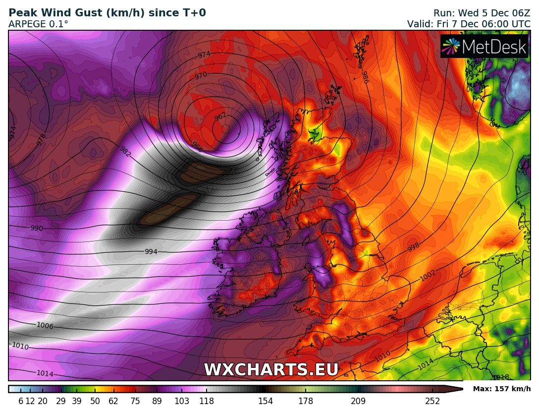
The image attached above is the last GFS weather model run not long in this morning and shows the risk of potentially severe and damaging gust across western, northwestern and northern parts of Ireland.
The UK met office already have a Yellow wind warning in place for strong and severe gusts for Friday morning and day for Northern Ireland, Scotland, Northern Wales and Northern England.
The UK Met Office also say there could be a risk of strong winds as there is a risk of the area of low pressure intensifying of the coast of Ireland or Scotland which may lead to a upgraded warning by them. You can see there latest forecast below
Mean while Met Eireann are warning that the strongest winds will be in the west of south of Ireland in there forecast but this forecast may change over the course of the day when further model runs come in.
Continues below


With the present track of this areas of low pressure there will be a high risk of coastal damage and flooding going on the model runs this morning across western, northwestern and northern parts of Ireland with the county’s of Galway, Mayo, Sligo, Leitrim, Donegal, Derry and Anrtrim worst effected. Strong winds, a large swell combined with a storm surge at high tide could lead to coastal flooding. One area of interest would be the Donegal bay area. Winds gusting between 100km/hr to 130km/hr could be possible on Friday morning depending if the strom intensify like some model suggest. Else where gusts of 80km/hr to 100km/hr would be possible elsewhere.
There is also the risk that a sting jet could form on this system on Friday morning
A sting jet is a meteorological phenomenon that forms as a part of some rapidly developing mid-latitude storms. The 'sting' part of the name refers to the scorpion's tail like shape that the clouds around a sting jet take on. The sting jet contains the most damaging winds, which can reach speeds of more than 100 mph.

Example of a STING JET

Example of a STING JET
Below you will find a chart from the GFS model run and the ARPEGE model run which are in good agreement. You will notice the gray and black areas over and of the west and northwest coast. If these show a track closer towards the coast then we could see even strong winds. As things are wind will still be severe and damaging looking at both models at present.

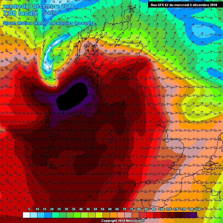
Latest GFS storm motion
A spell of rainfall also looks likely on Thursday night and Friday morning some showers will be thundery with the risk of hail along with the risk of strong gale force winds and potentially severe and damaging gusts.
I will further updates later this evening when a little more detail can be giving on this potential spell of really active weather and possible storm at the end of the week
KENNETH MC DONAGH FROM THE DONEGAL WEATHER CHANNEL

Make sure to give this article a like on Facebook
2019 CALENDAR NOW ON SALE


2019 Calendar now on sale
You can now purchase the Donegal Weather Channel Calendar 2019. You can purchase the Calendar from the online store
All calendars will be posted out in the middle of November with only a limited amount available. Calendars can be purchased anywhere across the world.


The stunning Leitir Mhic An Bhaird (Lettermacaward) Donegal during May 2018

Vivid Rainbow from up on Breezy mountain South Donegal


I was in Albufeira Portugal I was waiting for the full moon to come up and it did not let me down.
The orange and red tints that the Moon sometimes take on rising and setting are caused by the particles in the Earth's atmosphere. When light (or more specifically, packets of light called photons) from an astronomical object passes through the Earth's atmosphere, it scatters off of particles in the latter.

What a unbelievable night and morning out storm chasing, These number of thunderstorms had to be the best in years as most of the lightning was CG bolts. I even manage to captures Two to three CG bolts in one shot.

One of the most beautiful views of Slieve league From sea and got some nice photos.
Photos from this angle I have not seen yet and it was wonderful to finally capture that moment.
Follow Donegal Weather Channel on other social media platforms by clicking the icons below


