
SEVERE WIND STORM LOOKING LIKELY TO EFFECT IRELAND THURSDAY NIGHT INTO FRIDAY MORNING WITH DAMAGING GUSTS


wind
On Thursday night into Friday morning a deep area of low pressure looks set to track of the west and northwest coast of Ireland and could potentially give severe and damaging gusts. This storm system will have to be watched closely over the week as the path will determine how strong the winds will be. At present going by the latest model guidance this will be a named storm and a orange weather warning for strong winds look likely to be issued across Ireland.
Southwestern, western & northwestern parts may even need a red weather warning for wind on Friday morning especially coastal county’s as some models show the risk of gusts of 150km/hr or more over Friday AM.
The UK Met Office all ready have a early yellow weather warning in place for Northern Ireland and this most likely will also be upgrade to a amber warning closer to the time when a lot more detail is known about this Atlantic depression.
Looking at the ECMWF model run which I have attached below it shows severe and damaging gusts but is over cooking it a bit with some of the gust speeds. At present I would say gusts of up to 150km/hr would be possible along coastal parts of the west, southwest and northwest going by the latest runs but this will not be fully know until Wednesday night or Thursday morning . The GFS model also shows similar wind gusts.

Latest ECMWF model run shown severe and damaging gust on Friday morning with a red warning possible

Latest ECMWF model run shown severe and damaging gust on Friday morning with a red warning possible

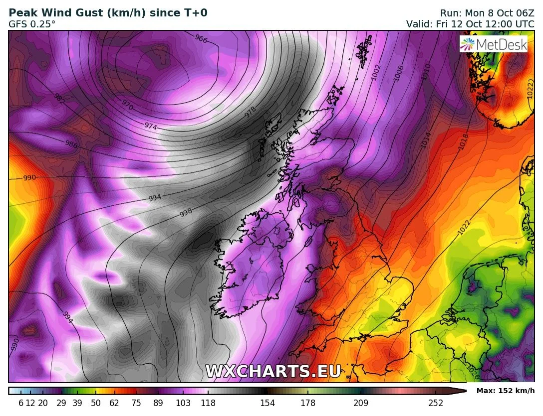
Latest GFS model run shown severe and damaging gust on Friday morning with a red warning possible

The latest Met Eireann high resolution model shown very strong gust on Friday morning

The latest Met Eireann high resolution model shown very strong gust on Friday morning
Continues below


Away from the southwest, west and northwest of Ireland gusts of between 110km/hr to 130km/hr may also be possible over the rest of Ireland as the storm tracks close to the west and northwest coast of Ireland. Winds will be south to southwesterly in direction.
rainfall and flooding
On Friday morning a spell of heavy rain will also accompany this Atlantic depression with flooding in parts of the country.
storm surge and coastal flooding

Along with the strong winds and rainfall this storm also shows the potential for coastal flooding in the southwestern, western and some northwestern coastal county’s with a large storm surge. Southwestern and western coastal county’s is at the risk of this in particular and should keep a eye on the forecast of the next 48hrs to 72hrs.
jet stream

The reason for this storm is due to a strong jet stream which acts like a conveyor belt rolling areas of low pressure in of the Atlantic. Shown in the chart above the jet stream will be very strong on Friday morning above Ireland.
Jet streams are fast flowing, narrow, meandering air currents in the atmospheres of some planets, including Earth. On Earth, the main jet streams are located near the altitude of the tropopause and are westerly winds (flowing west to east). Their paths typically have a meandering shape. Jet streams may start, stop, split into two or more parts, combine into one stream, or flow in various directions including opposite to the direction of the remainder of the jet. The jet stream wind speeds can exceed 320km/hr at its strongest.
Meteorologists use the location of some of the jet streams as an aid in weather forecasting.
Continues below
2019 CALENDAR NOW ON SALE


2019 Calendar now on sale
You can now purchase the Donegal Weather Channel Calendar 2019. You can purchase the Calendar from the online store
All calendars will be posted out in the middle of November with only a limited amount available. Calendars can be purchased anywhere across the world.
weekend
On this morning GFS model run it was also shown the risk of tropical storm Leslie passing of the west coast of Ireland on Saturday but this has since changed. Most model are keeping it of the western coast of Portugal with some bringing it inland over Portugal and Spain. but another scenario which could happen it makes a u turn and head back east across the Atlantic.
On Friday night and Saturday morning there also it the risk of another period of very heavy rain which could lead to flooding across Ireland.
It is important the public keep a eye on the latest forecast updates over the coming hours due to the spell of potentially disruptive weather over the end of the week and weekend. Any changes in the forecast and I will update.


The stunning Leitir Mhic An Bhaird (Lettermacaward) Donegal during May 2018

Vivid Rainbow from up on Breezy mountain South Donegal


I was in Albufeira Portugal I was waiting for the full moon to come up and it did not let me down.
The orange and red tints that the Moon sometimes take on rising and setting are caused by the particles in the Earth's atmosphere. When light (or more specifically, packets of light called photons) from an astronomical object passes through the Earth's atmosphere, it scatters off of particles in the latter.

What a unbelievable night and morning out storm chasing, These number of thunderstorms had to be the best in years as most of the lightning was CG bolts. I even manage to captures Two to three CG bolts in one shot.

One of the most beautiful views of Slieve league From sea and got some nice photos.
Photos from this angle I have not seen yet and it was wonderful to finally capture that moment.
Follow Donegal Weather Channel on other social media platforms by clicking the icons below


