
FIRST NAMED STORM OF THE SEASON - STORM ALI WITH STRONG WINDS LOOKS SET TO EFFECT IRELAND TUESDAY NIGHT INTO WEDNESDAY


With ex tropical storm Helene set to pass over Ireland on Monday bringing wet and windy weather to parts of Ireland it looks set to be followed by storm Ali. Ex tropical storm Helene wind speeds do not look like they will be severe as it was shown a number of days ago with the main wind field across the south, southeast and east of Ireland .
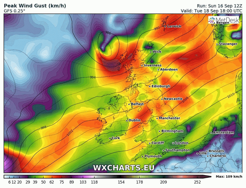
On Tuesday night and Wednesday morning a Atlantic low depression will move towards Ireland with the center of the depression passing of the west and northwest coast of Ireland with current projections shown the risk of stronger winds than Ex Tropical storm Helene was shown few days which was shown on models which I have mentioned on a few updates and nothing has changed. This wind storm at present looks set to be in the Orange weather warning criteria area with the strongest winds speeds and gusts across the west, northwest and north of Ireland with the potential for gust of between 110km/hr to 130km/hr in these areas. Strong winds also look likely across the rest of Ireland with gusts of around 80km.hr to 100km/hr.
If there is not much change in the next 24 hours on the model runs then this storm will be named Ali.
First named wind storm possible Tuesday night into Wednesday morning across Ireland and may be named Storm Ali
Anyone with any loss objects in there gardens or around your house like wheelie bins, trampolines or garden toys I would advise you secure them or take them inside as they could pose a danger and be easily picked up especially if you live in areas across Connacht, west & northUlster.
Some coastal flooding may also be possible along the west and northwest with a storm surge also possible from this system. This will depend on high tides in areas.
At the end of next week and over next weekend there could be further spells of windy weather that will effect Ireland and I will update on that once we get the next few hours over us.

Chart showing the Atlantic low passing Ireland on Tuesday into Wednesday

Chart showing the the Swell across the west of Ireland on Tuesday into Wednesday
Kenneth from the Donegal Weather Channel
CHECK OUT OUR ONLINE STORE


The stunning Leitir Mhic An Bhaird (Lettermacaward) Donegal during May 2018


This was a shot of a sunset i got back on May 2016 from Creevy Donegal Ireland while watching the sunset for over 2 hours.

I was in Albufeira Portugal I was waiting for the full moon to come up and it did not let me down.
The orange and red tints that the Moon sometimes take on rising and setting are caused by the particles in the Earth's atmosphere. When light (or more specifically, packets of light called photons) from an astronomical object passes through the Earth's atmosphere, it scatters off of particles in the latter.

What a unbelievable night and morning out storm chasing, These number of thunderstorms had to be the best in years as most of the lightning was CG bolts. I even manage to captures Two to three CG bolts in one shot.

One of the most beautiful views of Slieve league From sea and got some nice photos.
Photos from this angle I have not seen yet and it was wonderful to finally capture that moment.
Follow Donegal Weather Channel on other social media platforms by clicking the icons below


