
NO HURRICANE OR MASSIVE STORM SET TO HIT IRELAND IN THE NEXT 10 DAYS

I have been sent links to a article this morning and today by a number of people talking about a storm as strong as Ophelia to hit Ireland within two weeks.
Just to put out there that this is not the case and there are no signs of this happening.
There are signals for a Tropical storm to form in the the warmer waters of the Atlantic of the west of the African coast (Senegal) but it will not effect us.
And if the tropical storm moves northwards it will die off as it hits colder waters and gets caught in the jet stream..
The only storm at the minute is the the storm thats in the media about a phantom storm that is apparently going to pop out of nowhere.
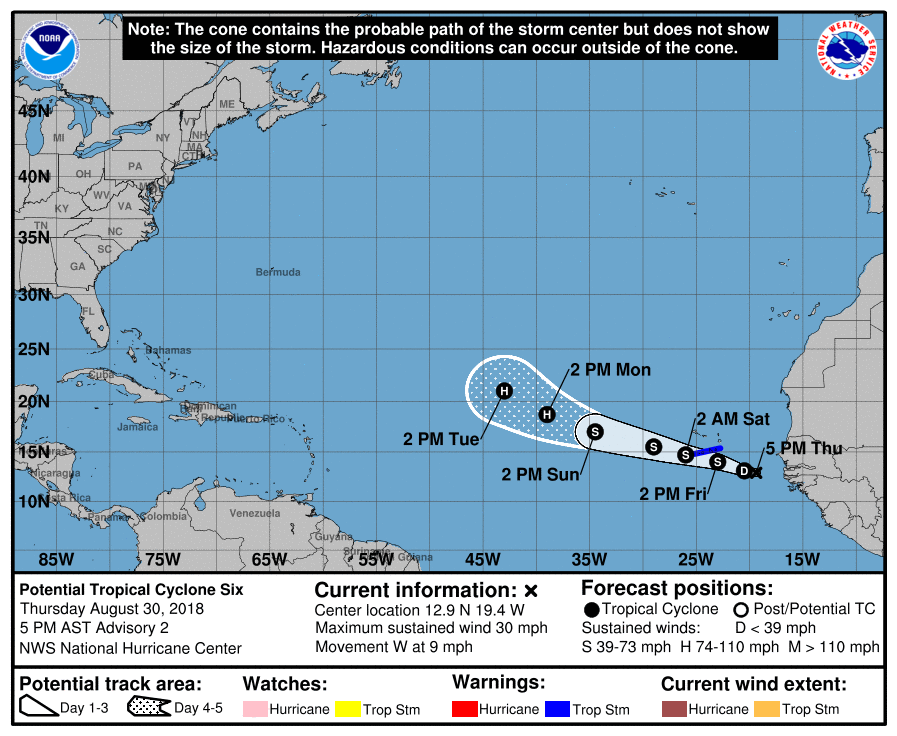
Update from the National Hurricane Center on this area of low pressure
Potential Tropical Cyclone Six Advisory Number 2
NWS National Hurricane Center Miami FL AL062018
500 PM AST Thu Aug 30 2018
...HEAVY RAINS AND GUSTY WINDS EXPECTED IN THE SOUTHERN CABO VERDE
ISLANDS ON FRIDAY...
SUMMARY OF 500 PM AST...2100 UTC...INFORMATION
----------------------------------------------
LOCATION...12.9N 19.4W
ABOUT 360 MI...580 KM ESE OF THE SOUTHERNMOST CABO VERDE ISLANDS
MAXIMUM SUSTAINED WINDS...30 MPH...45 KM/H
PRESENT MOVEMENT...W OR 280 DEGREES AT 9 MPH...15 KM/H
MINIMUM CENTRAL PRESSURE...1007 MB...29.74 INCHES
WATCHES AND WARNINGS
--------------------
CHANGES WITH THIS ADVISORY:
None.
SUMMARY OF WATCHES AND WARNINGS IN EFFECT:
A Tropical Storm Warning is in effect for...
* Santiago
* Fogo
* Brava
A Tropical Storm Warning means that tropical storm conditions are
expected somewhere within the warning area, in this case, within the
next 24 to 36 hours.
For storm information specific to your area, please monitor products
issued by your national meteorological service.
DISCUSSION AND OUTLOOK
----------------------
At 500 PM AST (2100 UTC), the disturbance was centered near latitude
12.9 North, longitude 19.4 West. The system is moving toward the
west near 9 mph (15 km/h), and a general west to west-northwest
track with an increase in forward speed is expected during the next
2 to 3 days. On the forecast track, the disturbance or the tropical
cyclone is expected to move near or over the southern Cabo Verde
Islands on Friday.
Maximum sustained winds remain near 30 mph (45 km/h) with higher
gusts. Some strengthening is forecast, and the disturbance is
expected to become a tropical storm during the next day or so.
Environmental conditions are favorable for the system to become a
tropical cyclone tonight or Friday.
* Formation chance through 48 hours...high...80 percent
* Formation chance through 5 days...high...90 percent
The estimated minimum central pressure is 1007 mb (29.74 inches).
HAZARDS AFFECTING LAND
----------------------
RAINFALL: The system could produce total rain accumulations of 4 to
8 inches across the southern Cabo Verde Islands. These rains could
produce life-threatening flash floods.
WINDS: Tropical storm conditions are expected in the southern Cabo
Verde Islands on Friday.
NEXT ADVISORY
-------------
Next intermediate advisory at 800 PM AST.
Next complete advisory at 1100 PM AST.
Kenneth Mc Donagh from the Donegal Weather Channel
Follow Donegal Weather Channel on other social media platforms by clicking the icons below


