
LAST FEW DAYS OF MAY LOOKING VERY WARM AND HUMID WITH TEMPERATURE AS HIGH AS 26C

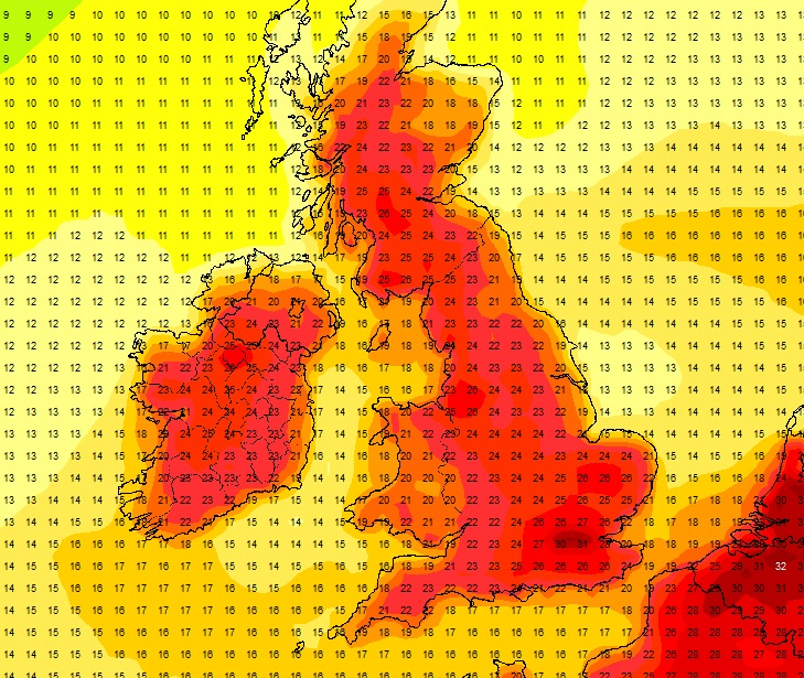
Latest GFS chart for the bank holiday showing showen temperature in the low 20s to mid 20s possible – image from the GFS net weather model
On this evenings GFS model run the early days of next week are looking very warm and humid across Ireland with temperatures in the low twenties and getting into the mid-twenties in places. Not only will temperatures be in the mid-twenties it will also be sunny across Ireland and the UK,
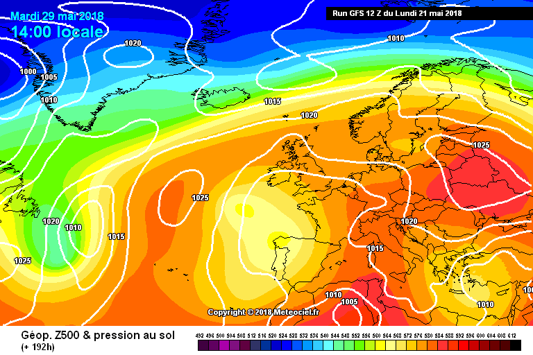
On the ECMWF 500mb anomaly chart which is attached below we can see high pressure in charge over the next 10 days over Western Europe (Ireland & the UK) red been high pressure and blue been low pressure. Over the rest of this month we will have above average heights over the country with the jet stream getting pushed way north above Iceland and north of Scandinavia.

ECMWF 500mb anomaly chart shown above average heights over the next 10 days
The GFS also shows nearly the same sort of set up again with see high pressure in charge over the next 10 days over Western Europe (Ireland & the UK) with above average heights over the country with the jet stream getting pushed way north above Iceland and north of Scandinavia.

GFS 500mb anomaly chart shown above average heights over the next 10 days
Over the next week to 10 days the temperatures will be above normal over Ireland and the UK.
Continues below


Rainfall will also be well below normal but with a area of low pressure of to the south this may well lead to very active thunderstorms over much of Ireland and the UK around the start of next week and mid-week next week.
The reason for this warmer air is due to high pressure to the northeast over Scandinavia with the source of the air coming from the continent in a south east to east flow feeding up very warm and humid conditions.
Another thing we need to watch for next week is high pressure beginning to weakling over France to our south and forming a low which could help trigger of some very active thundery weather over the county next week with strong lift and cape. If this happens then where looking at very active thunderstorms with intense lightning and very heavy showers especially over the afternoon hours if any heat does manage to build over the day hours.
At present over England and Wales on Monday there is the chance of very severe thunderstorms over the afternoon with very heavy showers which could lead to spot and flash flooding.
This week from Tuesday onwards will be mainly dry and turn warmer each day with temperatures up into the low 20s in parts by the end of the week and possibly into the mid-20s on Friday, Saturday and Sunday.
There will be very nice sunshine across the country over the next 7 to 10 days with the warmest temperatures this week and over the weekend been in the west and northwest of Ireland due to it been an easterly airflow. Across eastern parts it will be that bit cooler due to the off shore breeze but still presently warm with temperatures in the high teens and possibly hitting 20C on some days.
That’s it for this evenings update I will keep you up to date over the coming days on any further information and changes.
Kenneth from the Donegal Weather Channel
Pressure charts can be found below

High pressure over Ireland and the UK this weekend with a east to northeast flow
Warm humid air been directed towards Ireland and the UK early next week

High pressure in charge over the first week of June and stopping the Atlantic from moving in.

High pressure in charge over the first week of June and stopping the Atlantic from moving in.