


LEARN ABOUT
EARTHQUAKES & TSUNAMIS
EARTHQUAKES
WHAT IS AN EARTHQUAKE
An earthquake (also known as a quake, tremor or temblor) is the shaking of the surface of the Earth, resulting from the sudden release of energy in the Earth's lithosphere that creates seismic waves. Earthquakes can range in size from those that are so weak that they cannot be felt to those violent enough to toss people around and destroy whole cities. The seismicity or seismic activity of an area refers to the frequency, type and size of earthquakes experienced over a period of time. The word tremor is also used for non-earthquake seismic rumbling.
At the Earth's surface, earthquakes manifest themselves by shaking and sometimes displacement of the ground. When the epicentre of a large earthquake is located offshore, the seabed may be displaced sufficiently to cause a tsunami. Earthquakes can also trigger landslides, and occasionally volcanic activity.
In its most general sense, the word earthquake is used to describe any seismic event — whether natural or caused by humans — that generates seismic waves. Earthquakes are caused mostly by rupture of geological faults, but also by other events such as volcanic activity, landslides, mine blasts, and nuclear tests. An earthquake's point of initial rupture is called its focus or hypocenter. The epicentre is the point at ground level directly above the hypocenter.
TSUNAMI
WHAT IS A TSUNAMI
Tsunamis are giant waves caused by earthquakes or volcanic eruptions under the sea. Out in the depths of the ocean, tsunami waves do not dramatically increase in height. But as the waves travel inland, they build up to higher and higher heights as the depth of the ocean decreases. The speed of tsunami waves depends on ocean depth rather than the distance from the source of the wave. Tsunami waves may travel as fast as jet planes over deep waters, only slowing down when reaching shallow waters. While tsunamis are often referred to as tidal waves, this name is discouraged by oceanographers because tides have little to do with these giant waves.
HAS THERE EVER BEEN A TSUNAMI IN IRELAND OR THE UK
While we might not be within range of a strong earthquake, a tsunami resulting from seismic activity is real possibility and have hit Ireland in the past.
One extremely mild tsunami in 2011, more of a tidal surge, had a bizarre effect when a 40cm high wave was recorded in Devon, England,.
The incident caused fish to leap out of water, rivers to change direction, and there are several accounts of people’s hair standing on end due to static electricity.

However, there are several ways landslides or earthquakes that could result in a strong tsunami hitting Ireland
A future eruption of Cumbre Viejà volcano on La Palma, Canary Islands
Submarine landslides, in which a vast volume of material shifts underwater, could trigger on a tsumani. An extreme example of this is the 1998 tsunami in Papua New Guinea, which killed over 2,200 people.
The Azores-Gibraltar fault, which in 1755 and 1761 caused the two most recent tsunamis in Ireland, the former of which caused by an 8.6 magnitude earthquake in Lisbon and is thought to have caused waves up to 4 metres high. A 2 metre high wave hit Galway, damaging the city’s famous Spanish Arch.
A RECENT TSUNAMI – ST.STEPHENS DAY IN THE INIDIAN OCEAN
One of the most Recent Tsunami people will remember is the St. Stephens day Tsunami on December 26, 2004 in the Indian Ocean. The tsunami was caused by an earthquake that is thought to have had the energy of 23,000 Hiroshima-type atomic bombs. The epicenter of the 9.0 magnitude quake was located in the Indian Ocean near the west coast of Sumatra. The violent movement of the Earth’s tectonic plates displaced an enormous amount of water, sending powerful shock waves in every direction. The tectonic plates in this area had been pushing against each other and building pressure for thousands of years. They continue to do so and will likely cause underwater earthquakes and tsunamis in the future. The rupture was more than 600 miles long, displacing the seafloor by 10 yards horizontally and several yards vertically. As a result, trillions of tons of rock moved, causing the largest magnitude earthquake in 40 years. Within hours of the earthquake, killer waves radiating from the epicenter slammed into the coastlines of 11 countries, damaging countries from east Africa to Thailand. A tsunami is a series of waves - the first wave may not be the most dangerous. A tsunami “wave train” may come in surges five minutes to an hour apart. The cycle is marked by the repeated retreat and advance of the ocean. Despite a lag of up to several hours between the earthquake and the impact of the tsunami, nearly all of the victims were taken completely by surprise because there were no tsunami warning systems in place. The Indian Ocean tsunami travelled as far as 3,000 miles to Africa and still arrived with sufficient force to kill people and destroy property. Many people in Indonesia reported that they saw animals fleeing for high ground minutes before the tsunami arrived – very few animal bodies were found afterward. The tsunami resulted in at least 227,898 fatalities.
DO ALL EARTHQAUKES CAUSE TSUNAMIS?
Not all earthquakes cause tsunamis. There are four conditions necessary for an earthquake to cause a tsunami:
1. The earthquake must occur beneath the ocean or cause material to slide in the ocean.
2. The earthquake must be strong, at least magnitude 6.5.
3. The earthquake must rupture the Earth’s surface and it must occur at shallow depth – less than 70km below the surface of the Earth.
4. The earthquake must cause vertical movement of the sea floor (up to several metres).
Earthquakes
+ EARTHQAUKE’S IN IRELAND AND THE UK
Don’t be so shocked to see a earthquakes so close to Ireland. We have our own fault line in Donegal which is called the Leannan Fault line. Aligned northeast to southwest, the Great Glen Fault extends further southwest in a straight line through Loch Linnhe and the Firth of Lorne, and then on into north-western Ireland, directly through Lough Foyle, Donegal Bay and Clew Bay as the Leannan Fault. To the northeast the fault connects to the Walls Boundary Fault and the associated Melby Fault and Nesting’s Fault, before becoming obscured by the effects of Mesozoic rifting to the north of Shetland. The fault is mostly inactive today, but occasional moderate tremors have been recorded over the past 150 years. Ask the people living around the fault line from Donegal and they will tell you earthquakes in Ireland aren't a new thing to them but don't happen very often.
+ 2017 AND 1994 DONEGAL EARTHQUAKE
In fact the last earthquake in the county was back in 2017 on the 2nd of August when a magnitude 1.5 occurred in Donegal NE of Milford on the Fanad Peninsula. There are reports of this event having been felt in the area around Milford. Events of this nature are not uncommon in this region. The largest event recorded in this area was a magnitude 2.2 which occurred near Clonmany on 21st November 1994.
+ 2012 DONEGAL EARTHQUAKE
Previous to the 2017 Earthquake Donegal also experienced a larger magnitude 2.2 earthquake on Thursday the 26th of January 2012 People as far away as Letterkenny, Kilmacrennan and Ballybofey reported the rumblings, as well as more locally in Buncrana, Kerrykeel and Urris. People had reported this same quake to me on this night and described it as Thunder but after checking radar and data I could confirm there was nothing in the area and decided to ring the The British Geological Survey and Julian Bukits, assistant seismologist with the BGS where he confirmed to me soon after in fact it was a quake. If you look this up in the net you will see that many media sources report that too. The BGS has narrowed the epicentre of the quake down to a few hundred yards around the Knockalla Heights coast road, about five miles across Lough Swilly from Buncrana. Window frames shook and some people were woken up by this quake which happened in the early hours of the morning at 01:04 GMT.
+ EARTHQUAKE OF IRELANDS WEST COAST JUNE 2012
On the 6th of June 2012 another earthquake of a magnitude of 4.0 was also recorded of the west coast or Mayo which was also felt across parts of the west of Ireland on land. It happened 60 km off the County Mayo coast at 08:58 BST. According to the British Geological Survey (BGS), which monitors earthquake activity, it was strong enough to be felt in the county. The BGS said it had not recorded an earthquake of that magnitude in that area previously. The light tremor was measured at a depth of 15 km. Tom Blake from the Irish Seismic Network said the quake was the strongest since 1984 when an intermediate tremor of 5.4 was recorded in the Irish Sea. Similar sized earthquakes have been registered across the British Isles, normally every three to four years.
+ EARTHQUAKE IN CLARE 2010
The last similar-sized earthquake in Ireland was a 2.6 in north Clare in May 2010. Every year in Ireland and the UK there are 300 tremors recorded and a magnitude 4.0 earthquake happens in Ireland and the UK roughly every two years most of these earthquakes happen over England Wales and Scotland but in Ireland from time to time as well.
+ EARTHQAUKE IN DUBLIN ON 1984
In 1984, a 5.4 magnitude quake earthquake shook buildings in Dublin and caused damage near its epicentre in Wales, with some damage to buildings such as cracks and fallen chimneys.
+ EARTHQAUKE IN THE IRISH SEA ON 1951
One in 1951 with an epicentre in the Irish Sea was felt strongly along the east coast.
+ THE LARGEST EARTHQUAKE EVER RECORDED IN IRELAND AND THE UK
The worlds largest earthquake with an instrumentally documented magnitude occurred on May 22, 1960 near Valdivia, in southern Chile. It was assigned a magnitude of 9.5 by the United States Geological Survey. It is referred to as the "Great Chilean Earthquake" and the "1960 Valdivia earthquake.
+ LARGEST EVER DEAD TOLL FROM A EARTHQUAKE
1 - January 23, 1556 China, Shania a earthquake is reported to have killed 830,000 people 2 - July 27, 1976, China, Tangshan is reported to have killed 255,000 officially but a estimated 655,000 people lost their life. 3 - Dec. 26, 2004 the one many people will remember on St Stephen's day the Sumatra, Indonesia earthquake and Tsunami which took the life's of 227,898. So you may ask will there be further earthquakes in Ireland? Yes there will be. Will there be earth quakes in Donegal again? Yes there will be. So don't be leaving your tea cups made out of China lying around lose ladies.
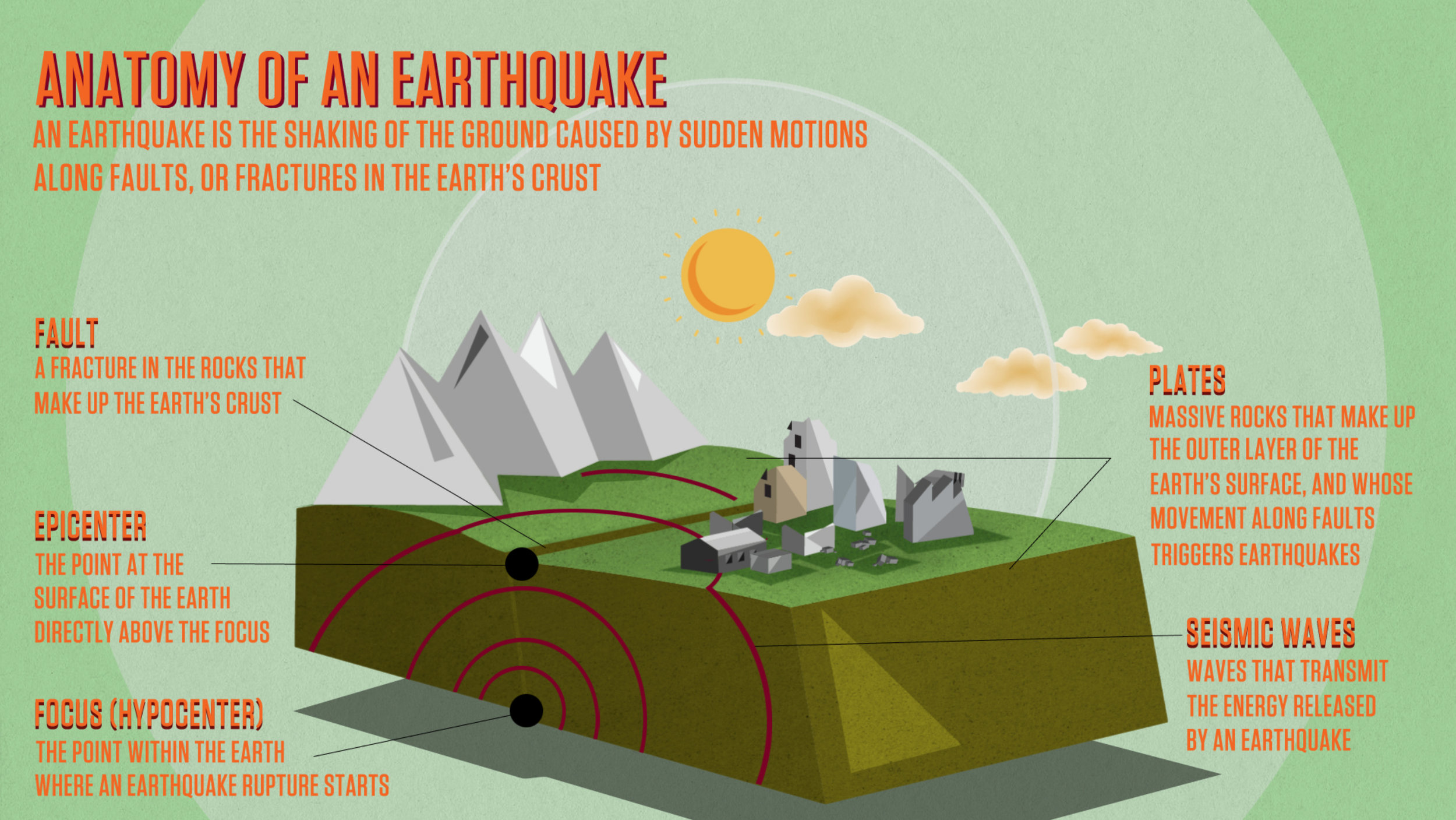
+ EARTHQAUKE - FAULT LINES
Earthquakes occur on faults. A fault is a thin zone of crushed rock separating blocks of the earth's crust. When an earthquake occurs on one of these faults, the rock on one side of the fault slips with respect to the other. The fault surface can be vertical, horizontal, or at some angle to the surface of the earth. An earthquake is caused by a sudden slip on a fault. Stresses in the earth's outer layer push the sides of the fault together. Stress builds up and the rocks slips suddenly, releasing energy in waves that travel through the earth's crust and cause the shaking that we feel during an earthquake.
+ EARTHQAUKE – PLATES
Plates move away from one another at divergent boundaries. This happens at mid-ocean ridges. Plates move towards one another at convergent boundaries; one plate is forced below another in a process called subduction. Earthquakes and composite volcanoes are common at this type of boundary.
+ EARTHQUAKE – EPICENTER & FOCUS
Epicenter -The point on the Earth's surface located directly above the focus of an earthquake. Focus-The location where the earthquake begins. The ground ruptures at this spot, then seismic waves radiate outward in all directions.
+ EARTHQUAKE – SEISMIC WAVE
A seismic wave is an elastic wave generated by an impulse such as an earthquake or an explosion. Seismic waves may travel either along or near the earth's surface
+ EARTHQUAKE – AFTER SHOCKS
An aftershock is a smaller earthquake that occurs after a previous large earthquake, in the same area of the main shock. If an aftershock is larger than the main shock, theaftershock is redesignated as the main shock and the original main shock is redesignated as a foreshock.
+ EARTHQUAKE – SUBDUCTION
Subduction is a geological process that takes place at convergent boundaries of tectonic plates where one plate moves under another and is forced or sinks due to gravity into the mantle. Regions where this process occurs are known as subduction zones.
+ EARTHQUAKE – SHALLOW AND DEEP EARTHQAUKES
Determining the Depth of an Earthquake. ... Shallow earthquakes are between 0 and 70 km deep; intermediate earthquakes, 70 - 300 km deep; and deep earthquakes, 300 - 700 km deep. In general, the term "deep-focus earthquakes" is applied to earthquakes deeper than 70 km. The most destructive tsunamis are generated from large, shallow earthquakes with an epicenter or fault line near or on the ocean floor. These usually occur in regions of the earth characterized by tectonic subduction along tectonic plate boundaries. ... It should be noted that not all earthquakes generate tsunamis.